Support the Arctic Sea Ice Forum and Blog

Author Topic: The 2015/2016 freezing season  (Read 431008 times)

plg

  • New ice
  • Posts: 76
    • View Profile
  • Liked: 1
  • Likes Given: 0
Re: The 2015/2016 freezing season
« Reply #250 on: January 18, 2016, 04:33:00 PM »
It seems fairly safe to assume 2016 will be among the lowest (3?) maxima, however perhaps of equal interest is the date of maximum.

By pure speculation based on the injection of warmth into the Arctic it appears likely to expect a maximum for extent/area in the second half of February, modulo sudden colder weather.

Too low now (due to recent warm winds) would suggest to me a late maximum like 2012. But depends a lot on weather near the minimum which we cannot predict.

Interesting that you come to the opposite conclusion, but I believe I understand the reasoning.

In any case, it all comes down to weather, as you pointed out.
If you are not paranoid you just do not have enough information yet.

Sleepy

  • Guest
Re: The 2015/2016 freezing season
« Reply #251 on: January 18, 2016, 04:43:54 PM »
<snippage>

MMh, that sound like El Nino is a big and a huge deal, almost like there's nothing else to follow, well, it is a big deal, but the reason (to me) why it's so hot this time around is AGW, so there (huh, saved the scientificallic point, at the last moment).

I agree, the greatest effects will be 18-24 months in our future as the heat fully distributes around the globe. 

Haven't followed this thread, but may I add that this AGW enhanced El Nino started in 2014. JMA declared El Nino conditions then, and when you look att the upper ocean heat anomalies in the pacific they were high already in 2014. In my mind it would be possible to see the effects sooner, or?

crandles

  • Young ice
  • Posts: 3379
    • View Profile
  • Liked: 239
  • Likes Given: 81
Re: The 2015/2016 freezing season
« Reply #252 on: January 18, 2016, 05:46:28 PM »
It seems fairly safe to assume 2016 will be among the lowest (3?) maxima, however perhaps of equal interest is the date of maximum.

By pure speculation based on the injection of warmth into the Arctic it appears likely to expect a maximum for extent/area in the second half of February, modulo sudden colder weather.

Too low now (due to recent warm winds) would suggest to me a late maximum like 2012. But depends a lot on weather near the minimum which we cannot predict.

Interesting that you come to the opposite conclusion, but I believe I understand the reasoning.

In any case, it all comes down to weather, as you pointed out.

A slightly different argument which I think I have made in previous years:

It could be argued that a low maximum causes a late maximum. Low maximum means ice edges are generally further north, so you have to wait until later in the season for the sun angle to get as high to get to the point where enough energy is provided to stop the ice edge spreading.

I think this is supported by a fairly weak trend towards later maximums in more recent years.

Whatever the reason for the trend (assuming such a trend is real and not from random chance), it seems highly likely to be a weak influence compared to weather.

(Sorry if I have forgotten details like how robust the trend is.)

jdallen

  • Young ice
  • Posts: 3412
    • View Profile
  • Liked: 651
  • Likes Given: 244
Re: The 2015/2016 freezing season
« Reply #253 on: January 18, 2016, 08:13:23 PM »
<snippage>

A slightly different argument which I think I have made in previous years:

It could be argued that a low maximum causes a late maximum. Low maximum means ice edges are generally further north, so you have to wait until later in the season for the sun angle to get as high to get to the point where enough energy is provided to stop the ice edge spreading.

I think this is supported by a fairly weak trend towards later maximums in more recent years.

Whatever the reason for the trend (assuming such a trend is real and not from random chance), it seems highly likely to be a weak influence compared to weather.

(Sorry if I have forgotten details like how robust the trend is.)
[/quote]

Initially seems counter intuitive until you begin considering the shifting dynamics of the forces playing in the region over time.  Later lower maxima make complete sense.

That said, even if we have a cold shift in the weather, and we end up 500,000 - 1,000,000 KM2 higher than the maxima last year, I think the damage has already been done to the ice.  The weather has kept a huge amount of energy pent up in the arctic.  Not enough time remains for it to get dumped before the sun returns.
This space for Rent.

crandles

  • Young ice
  • Posts: 3379
    • View Profile
  • Liked: 239
  • Likes Given: 81
Re: The 2015/2016 freezing season
« Reply #254 on: January 18, 2016, 08:33:42 PM »
'the damage' being low rate of rise of volume and I do expect that in early January. Maybe go from 4th lowest volume to 3rd lowest volume for the time of year?

However, I would suggest still plenty of winter to go before volume peaks yet.

or as NSIDC has said of New Year brief polar heat wave
Quote
While the event was remarkable and may account for the slow ice growth during the first few days of January 2016, it was short lived and is unlikely to have any long-term effects on the sea ice cover.
http://nsidc.org/arcticseaicenews/2016/01/

Jim Hunt

  • First-year ice
  • Posts: 6274
  • Don't Vote NatC or PopCon, Save Lives!
    • View Profile
    • The Arctic sea ice Great White Con
  • Liked: 895
  • Likes Given: 87
Re: The 2015/2016 freezing season
« Reply #255 on: January 18, 2016, 11:33:06 PM »
Yes, one week later and things are under control again. Now it's one more week of hard work and everything will be back to normal. Normal being me looking at Arctic sea ice.  ;D

I'm glad to hear that Neven.

I was also very happy to get wet in the swell provided by Hurricane Alex. Hopefully I'm at least vaguely on topic when I point out that temperatures in Southern Greenland yesterday were on a par with those in Soggy South West England. The winds were somewhat stronger up there though!

http://GreatWhiteCon.info/2016/01/is-the-son-of-storm-frank-heading-for-the-arctic/#comment-213202
"The most revolutionary thing one can do always is to proclaim loudly what is happening" - Rosa Luxemburg

jdallen

  • Young ice
  • Posts: 3412
    • View Profile
  • Liked: 651
  • Likes Given: 244
Re: The 2015/2016 freezing season
« Reply #256 on: January 19, 2016, 12:10:12 AM »
'the damage' being low rate of rise of volume and I do expect that in early January. Maybe go from 4th lowest volume to 3rd lowest volume for the time of year?

However, I would suggest still plenty of winter to go before volume peaks yet.

or as NSIDC has said of New Year brief polar heat wave
Quote
While the event was remarkable and may account for the slow ice growth during the first few days of January 2016, it was short lived and is unlikely to have any long-term effects on the sea ice cover.
http://nsidc.org/arcticseaicenews/2016/01/
I wish we had the 80N numbers from DMI.  From following Climate Reanalyzer on a daily basis, I'm not sure the last two weeks have been much better.
This space for Rent.

Tor Bejnar

  • Young ice
  • Posts: 4606
    • View Profile
  • Liked: 879
  • Likes Given: 826
Re: The 2015/2016 freezing season
« Reply #257 on: January 19, 2016, 01:00:03 AM »

... may I add that this AGW enhanced El Nino started in 2014. JMA declared El Nino conditions then, and when you look att the upper ocean heat anomalies in the pacific they were high already in 2014. In my mind it would be possible to see the effects sooner, or?

I've been thinking this same thing.  Could a long-lived El Nino cause two or three years of record global warmth, and not just one or two?
Arctic ice is healthy for children and other living things because "we cannot negotiate with the melting point of ice"

Pmt111500

  • Guest
Re: The 2015/2016 freezing season
« Reply #258 on: January 19, 2016, 03:26:37 AM »

... may I add that this AGW enhanced El Nino started in 2014. JMA declared El Nino conditions then, and when you look att the upper ocean heat anomalies in the pacific they were high already in 2014. In my mind it would be possible to see the effects sooner, or?

I've been thinking this same thing.  Could a long-lived El Nino cause two or three years of record global warmth, and not just one or two?

Oh, that's true in my mind too, the ocean currents though don't return to normal as long as El Nino is going on, so this year should see some warming because of atmospheric effects of the 2014 episode too. Everything is moving so it's hard to keep track...

Sleepy

  • Guest
Re: The 2015/2016 freezing season
« Reply #259 on: January 19, 2016, 03:43:59 AM »
Tor & Pmt, as things looks now and apart from 2014 and 2015, we can put a check on 2016 as a very warm year as well.

Following the temperatures in the Nino4 region which lingers on, if we should have a La Nina this year it will be late and not strong. Compared to 97/98 this event is more like a slow and heavy freight train. WWBs were harder in 97/98, maximium temperatures were higher as well. But this one is larger. And it's not tapering off as fast as models and forecasts have been indicating.

And how will that affect the melt later on this year in the Arctic? Shouldn't there be a drop already this season?

Edit; sloppy writing as usual, I meant maximum temperature anomalies were higher.
« Last Edit: January 19, 2016, 04:06:18 AM by Sleepy »

Pmt111500

  • Guest
Re: The 2015/2016 freezing season
« Reply #260 on: January 19, 2016, 05:08:32 AM »
Tor & Pmt, as things looks now and apart from 2014 and 2015, we can put a check on 2016 as a very warm year as well.

 for the tropospheric T's in low and partly middle latitudes, on high latitudes, not necessarily (weather).

Following the temperatures in the Nino4 region which lingers on, if we should have a La Nina this year it will be late and not strong. Compared to 97/98 this event is more like a slow and heavy freight train. WWBs were harder in 97/98, maximium temperatures were higher as well. But this one is larger. And it's not tapering off as fast as models and forecasts have been indicating.

And how will that affect the melt later on this year in the Arctic? Shouldn't there be a drop already this season?
Currently, I'd be most interested to know how the refreeze 2016 begins. In my mind the warmer currents reaching arctic are the worst for ice, so I'd wait for 2017 for the big melt... I don't remember seeing studies over what sort of high or low pressure areas there are dominant in the arctic during waning El Ninos, but entirely possible that there is quite a lot of ice loss already this year, be it from direct melting or from export. The difficulty here would be that the former is more of a matter of summer-time high pressures and the latter because of low pressures. Either extreme would be bad, I guess, but where's the limit of what's bad for ice? As have been stated by more experienced commentators, the energy for big melt is already extant (in the Ocean deep layers), it's only a matter of how it gets to the Arctic Ocean surface.

I think this El Nino most resembles the 1982-83 one, too bad the El Chichon volcano very much masked it's influence so we cannot take clues from it... then there's at least the wartime El Nino of 1940-1? , and everyone knows how reliable records are during wartime... I haven't looked up the weather stuff from early days of ENSO record.

Sleepy

  • Guest
Re: The 2015/2016 freezing season
« Reply #261 on: January 19, 2016, 05:40:17 AM »
Thanks for the input Pmt.
I know that Scandinavia normally gets colder weather after El Ninos, but we can't get much colder than we have had during the recent cold spell, after eyeballing temperatures over the Arctic. And yes, I've been looking at the 82-83 El Nino as well. A small animation for those years via NSIDC. 84-85 were lower/later during refreeze as well. Is there a more elaborate explanation for 84-85? Click to animate.

Pmt111500

  • Guest
Re: The 2015/2016 freezing season
« Reply #262 on: January 19, 2016, 05:57:44 AM »
Thanks for the input Pmt.
I know that Scandinavia normally gets colder weather after El Ninos, but we can't get much colder than we have had during the recent cold spell, after eyeballing temperatures over the Arctic.
Yes, at one point Lapland had the 8th lowest T's on anywhere in NH, the only colder places were the eastern Siberia highland valleys... Canada and Greenland (including the Summit station) were warm compared to Lapland then. Still it's cold, but now when the western winds touch the southernmost Finland the freezing Baltic throws snows over this area regularly...yesterday spent over an hour piling snow in the yard (manually). The upshot of this cold spell has (to some) been that the river has frozen thickly enough to skate on.

No comment on 1984-5.

Gotta go for now. Nice to talk.

S.Pansa

  • Frazil ice
  • Posts: 175
    • View Profile
  • Liked: 45
  • Likes Given: 5
Re: The 2015/2016 freezing season
« Reply #263 on: January 19, 2016, 07:02:15 AM »
'the damage' being low rate of rise of volume and I do expect that in early January. Maybe go from 4th lowest volume to 3rd lowest volume for the time of year?

However, I would suggest still plenty of winter to go before volume peaks yet.

or as NSIDC has said of New Year brief polar heat wave
Quote
While the event was remarkable and may account for the slow ice growth during the first few days of January 2016, it was short lived and is unlikely to have any long-term effects on the sea ice cover.
http://nsidc.org/arcticseaicenews/2016/01/
I wish we had the 80N numbers from DMI.  From following Climate Reanalyzer on a daily basis, I'm not sure the last two weeks have been much better.

You can find them on Andrew Slaters page here.
He has also the temps for the entire Arctic Ocean (925 hPA). 2016 looks to be quite warm so fare.

Neven

  • Administrator
  • First-year ice
  • Posts: 9518
    • View Profile
    • Arctic Sea Ice Blog
  • Liked: 1337
  • Likes Given: 618
Re: The 2015/2016 freezing season
« Reply #264 on: January 19, 2016, 08:59:15 AM »
You can find them on Andrew Slaters page here.
He has also the temps for the entire Arctic Ocean (925 hPA). 2016 looks to be quite warm so fare.

Thanks for this, Sancho. I've added that graph to the ASIG daily graphs page.
The enemy is within
Don't confuse me with him

E. Smith

jdallen

  • Young ice
  • Posts: 3412
    • View Profile
  • Liked: 651
  • Likes Given: 244
Re: The 2015/2016 freezing season
« Reply #265 on: January 19, 2016, 09:35:43 AM »
<snippage>
 2016 looks to be quite warm so fare.
Warm, Hell, we're 10C above the median.

Your capacity for understatement is considerable.
This space for Rent.

Jim Hunt

  • First-year ice
  • Posts: 6274
  • Don't Vote NatC or PopCon, Save Lives!
    • View Profile
    • The Arctic sea ice Great White Con
  • Liked: 895
  • Likes Given: 87
Re: The 2015/2016 freezing season
« Reply #266 on: January 19, 2016, 10:17:45 AM »
I wish we had the 80N numbers from DMI.

Reposting from the ASIB yesterday:

Quote
Just to set the record straight, I often call DMI, I've never heard any canned music, and they've always been very helpful.

On this occasion I am reliably informed that:

1) ocean.dmi.dk is not an "operational" site

2) They had a computer crash earlier in the year.

3) The guy whose "best efforts" maintain the temperature data has been out in "the field" for a couple of weeks. He was due back last Thursday, but what with one thing and another is not now expected until this evening

4) Expect normal service to be resumed RSN!
"The most revolutionary thing one can do always is to proclaim loudly what is happening" - Rosa Luxemburg

Gray-Wolf

  • Grease ice
  • Posts: 948
    • View Profile
  • Liked: 131
  • Likes Given: 461
Re: The 2015/2016 freezing season
« Reply #267 on: January 19, 2016, 10:54:04 AM »
Well the 'cold pool' ,south of Greenland, appears to want to keep lows sat over Iceland and pump warmth up into Fram (with a frequent plunge of cold down into Greenland as the process rolls out?)

I cannot see this alter much for the rest of our winter? This then leaves me looking at spring and wondering how a northerly migrating jet messes with this process?

I'm thinking we will see the 'nino warmth' make early inroads into the pack from the get go? The rest is down to how much sun the basin sees over the same period?

KOYAANISQATSI

ko.yaa.nis.katsi (from the Hopi language), n. 1. crazy life. 2. life in turmoil. 3. life disintegrating. 4. life out of balance. 5. a state of life that calls for another way of living.
 
VIRESCIT VULNERE VIRTUS

Jim Hunt

  • First-year ice
  • Posts: 6274
  • Don't Vote NatC or PopCon, Save Lives!
    • View Profile
    • The Arctic sea ice Great White Con
  • Liked: 895
  • Likes Given: 87
Re: The 2015/2016 freezing season
« Reply #268 on: January 19, 2016, 01:20:29 PM »
Here is the surf forecast for Greenland and Alaska, amongst other places:

Two Pairs of Hurricane Force Storms

Quote
The Ocean Prediction Center of the United States' National Weather Service highlighted this unusual situation on their Twitter feed yesterday - "Four hurricane force lows in the two ocean basins within the next 24 hours!"
"The most revolutionary thing one can do always is to proclaim loudly what is happening" - Rosa Luxemburg

crandles

  • Young ice
  • Posts: 3379
    • View Profile
  • Liked: 239
  • Likes Given: 81
Re: The 2015/2016 freezing season
« Reply #269 on: January 19, 2016, 01:33:24 PM »
now available

at
http://ocean.dmi.dk/arctic/plots/meanTarchive/meanT_2016.png
though I like the recently added chart better.  :)

plg

  • New ice
  • Posts: 76
    • View Profile
  • Liked: 1
  • Likes Given: 0
Re: The 2015/2016 freezing season
« Reply #270 on: January 19, 2016, 03:33:37 PM »
It seems fairly safe to assume 2016 will be among the lowest (3?) maxima, however perhaps of equal interest is the date of maximum.

By pure speculation based on the injection of warmth into the Arctic it appears likely to expect a maximum for extent/area in the second half of February, modulo sudden colder weather.

Too low now (due to recent warm winds) would suggest to me a late maximum like 2012. But depends a lot on weather near the minimum which we cannot predict.

Interesting that you come to the opposite conclusion, but I believe I understand the reasoning.

In any case, it all comes down to weather, as you pointed out.

A slightly different argument which I think I have made in previous years:

It could be argued that a low maximum causes a late maximum. Low maximum means ice edges are generally further north, so you have to wait until later in the season for the sun angle to get as high to get to the point where enough energy is provided to stop the ice edge spreading.

I think this is supported by a fairly weak trend towards later maximums in more recent years.

Whatever the reason for the trend (assuming such a trend is real and not from random chance), it seems highly likely to be a weak influence compared to weather.

(Sorry if I have forgotten details like how robust the trend is.)

No real obvious trend for Cryospere, IARC-JAXA (IJIS) and NSIDC, see below.

[EDIT: Note to self: do not include current year as it distorts the graph... Too late now.]
« Last Edit: January 19, 2016, 04:14:55 PM by plg »
If you are not paranoid you just do not have enough information yet.

crandles

  • Young ice
  • Posts: 3379
    • View Profile
  • Liked: 239
  • Likes Given: 81
Re: The 2015/2016 freezing season
« Reply #271 on: January 19, 2016, 05:43:25 PM »
No real obvious trend for Cryospere, IARC-JAXA (IJIS) and NSIDC, see below.

Thanks plg.

Struggling to remember details: I am wondering if I remember discussion or calculations of where peak of something like a 14 day average occurred. It might help hide noise of weather and show trend more clearly. I knew trend wasn't strong but those graphs make it look non existent. Scatter graph of day of peak of 14 day average versus amount of maximum might be something else to try; don't remember seeing such though.

werther

  • Grease ice
  • Posts: 747
    • View Profile
  • Liked: 31
  • Likes Given: 0
Re: The 2015/2016 freezing season
« Reply #272 on: January 19, 2016, 08:56:08 PM »
Hallmark of Arctic Amplification:


This NCEP/NCAR map shows what I call ‘winterpower’ since the start of last October. It looks like this winter has little time left for some real cold to stimulate ice growth.
In contrast to last season, the Barentsz sector is back on the usual large positive anomalies. A lot of open water and a come and go of warm Atlantic lows.

Somewhat unusual is the large swath of >6dC anomalies North of the Canadian Archipelago. It indicates that the Arctic winter is gradually ‘warming up’, most pronounced in years like this. It was suggested before, that stored heat in the oceans will come back to haunt us.
Since this is only the beginning of effects following strong heat release in the Pacific and Atlantic, it seems unlikely ‘winterpower’ will look better for the ice in March.

Buddy

  • Young ice
  • Posts: 3379
  • Go DUCKS!!
    • View Profile
  • Liked: 49
  • Likes Given: 34
Re: The 2015/2016 freezing season
« Reply #273 on: January 19, 2016, 09:06:45 PM »
Quote
Somewhat unusual is the large swath of >6dC anomalies North of the Canadian Archipelago.

Temperatures in the Canadian Archipelago and south of the arch.....have had significant warm anomalies over the past 6 weeks or more.  I have been keeping a close eye on it.

If that keeps up....going to be a nasty late spring melt....
FOX (RT) News....."The Trump Channel.....where truth and journalism are dead."

werther

  • Grease ice
  • Posts: 747
    • View Profile
  • Liked: 31
  • Likes Given: 0
Re: The 2015/2016 freezing season
« Reply #274 on: January 19, 2016, 09:11:25 PM »
Keep an eye on it Buddy. I'm looking forward to see the first MODIS tiles when the daylight returns.

Forecast by ECMWF:


Another gust of warmth deep into total darkness.

jdallen

  • Young ice
  • Posts: 3412
    • View Profile
  • Liked: 651
  • Likes Given: 244
Re: The 2015/2016 freezing season
« Reply #275 on: January 19, 2016, 10:31:58 PM »
Keep an eye on it Buddy. I'm looking forward to see the first MODIS tiles when the daylight returns.

<snippage>

Another gust of warmth deep into total darkness.

Yup, about 4 days out, 0C across almost half of 80N, possibly including the pole. Once in a season is an anomaly.  Twice I think constitutes climate change.

Also relevant - after the unseasonably warm fall and start to winter, a major Arctic outbreak is going to descend on the US Eastern seaboard, bringing what forecasters are calling a textbook Northeaster.

A persistent powerful high pressure system over Quebec is driving are out of the Arctic, helping it's evil twin - the remnants of Alex, still carrying hurricane force winds - to shove heat into the CAB.

Now *thinking* about that spring melt, what if we see a repeat of this storm... In April?

Yah, I'm worried.  Who needs June melt ponds if you can substitute open water and deep heat from Ekman pumping? Besides, we could end up with both. (oO)
This space for Rent.

Pmt111500

  • Guest
Re: The 2015/2016 freezing season
« Reply #276 on: January 20, 2016, 02:27:46 AM »
No real obvious trend for Cryospere, IARC-JAXA (IJIS) and NSIDC, see below.

Thanks plg.

Struggling to remember details: I am wondering if I remember discussion or calculations of where peak of something like a 14 day average occurred. It might help hide noise of weather and show trend more clearly. I knew trend wasn't strong but those graphs make it look non existent. Scatter graph of day of peak of 14 day average versus amount of maximum might be something else to try; don't remember seeing such though.

That was likely me who was annoyed of the wobbling nature of everyday weather on the fringes of the ice pack. I at least used longer 5-day  averages (and likely also 15-day averages on occasion to keep the possible lunar influence in) calculating these sorts of not too scientific things a couple of years back  (2013 or 2014).

Theta

  • Frazil ice
  • Posts: 174
  • Grips
    • View Profile
  • Liked: 0
  • Likes Given: 1
Re: The 2015/2016 freezing season
« Reply #277 on: January 20, 2016, 02:36:09 AM »
Keep an eye on it Buddy. I'm looking forward to see the first MODIS tiles when the daylight returns.

<snippage>

Another gust of warmth deep into total darkness.

Yup, about 4 days out, 0C across almost half of 80N, possibly including the pole. Once in a season is an anomaly.  Twice I think constitutes climate change.

Also relevant - after the unseasonably warm fall and start to winter, a major Arctic outbreak is going to descend on the US Eastern seaboard, bringing what forecasters are calling a textbook Northeaster.

A persistent powerful high pressure system over Quebec is driving are out of the Arctic, helping it's evil twin - the remnants of Alex, still carrying hurricane force winds - to shove heat into the CAB.

Now *thinking* about that spring melt, what if we see a repeat of this storm... In April?

Yah, I'm worried.  Who needs June melt ponds if you can substitute open water and deep heat from Ekman pumping? Besides, we could end up with both. (oO)

Things appear to be a lot scarier in the arctic than what we encountered in 2013, 2014 and even 2015. We seem to have entered a new phase for the arctic, the only question that remains now is, how bad will the melt season be as this year is lion my like "the" year where we lose all of the ice.
Can't think of a signature

jdallen

  • Young ice
  • Posts: 3412
    • View Profile
  • Liked: 651
  • Likes Given: 244
Re: The 2015/2016 freezing season
« Reply #278 on: January 20, 2016, 04:26:40 AM »

Things appear to be a lot scarier in the arctic than what we encountered in 2013, 2014 and even 2015. We seem to have entered a new phase for the arctic, the only question that remains now is, how bad will the melt season be as this year is lion my like "the" year where we lose all of the ice.
Still a very long way from that, though I think a possible sub-3 million KM2 minimum is very much in play.
This space for Rent.

Gray-Wolf

  • Grease ice
  • Posts: 948
    • View Profile
  • Liked: 131
  • Likes Given: 461
Re: The 2015/2016 freezing season
« Reply #279 on: January 20, 2016, 10:24:19 AM »
After the 2007 shock it was discovered the the 'perfect melt storm' rolled around on a cycle of between 10 and 20 years ( the the two prior to 07' having 10 yr spacing) so I will be even more attentive to this melt season as it may well impact the 2017 season which could see the return of the 'perfect melt storm' synoptic.

But then maybe 'weather' has now become so impacted that we will no longer have this cycle roll around? Maybe the imposition of the 'wavy jet' and stuck weather patterns have made it redundant.

The other thing that post 07' years showed us was just how much 'in-situ' melt could claim over a melt season ( and a rough guide to the 'thickness' we should expect to lose over an average melt season?). A bad winter means we enter melt season with a pack that closer matches the amount of ice it is possible to lose over an 'average' season?

And now we roll into 'crackopalypse' end of re-freeze. I wonder if this year will see any major fracturing in Beaufort/north of Greenland? Past years had me wondering just how much of that broken ice would flow out of Fram given the right weather system/s over the basin? Will this years volatile weather assaulting the basin I have to wonder if this year 'export' will make a significant impact over early melt season?

KOYAANISQATSI

ko.yaa.nis.katsi (from the Hopi language), n. 1. crazy life. 2. life in turmoil. 3. life disintegrating. 4. life out of balance. 5. a state of life that calls for another way of living.
 
VIRESCIT VULNERE VIRTUS

werther

  • Grease ice
  • Posts: 747
    • View Profile
  • Liked: 31
  • Likes Given: 0
Re: The 2015/2016 freezing season
« Reply #280 on: January 20, 2016, 12:19:12 PM »
Morning Gray-Wolf,
Your post reminded me of my work on ‘winterpower’. About two years ago I worked back through the NCEP/NCAR composites to see whether there’s a trend in winter warming. I couldn’t come up with much; most winters show warming last two decades but there was large interannual variance.
Nevertheless, when this winter up to now is compared to the past three seasons, it does look like circumstances won’t be good for the ice next summer:


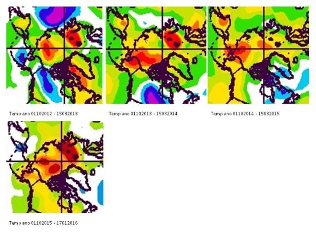
Although the positive anomaly during 14-15 looks smallest, summer 15 produced some bad melting. That fact puts the importance of winter cold in perspective. A bad summer  will probably trash the ice, whatever winter now precedes.

As heat released from the oceans is bound to influence this whole year and probably part of ’17, I still point to ’17 for the year that might produce another ‘black swan’- event. Like I wrote earlier last year, that event won’t immediately produce an icefree Arctic Ocean in September (<1Mkm2). It will result in a next melting plateau for some years.

I’d forecast around ’23 for the first ice-free September to occur. That stage will in my opinion trigger an irreversible course to a perennial-ice-free state of the Arctic some ten years later.

It seems hard to imagine when I consider the past trends. But as the climate system is by now in course of rapid transition, extrapolation from the past is not of much use anymore.

plg

  • New ice
  • Posts: 76
    • View Profile
  • Liked: 1
  • Likes Given: 0
Re: The 2015/2016 freezing season
« Reply #281 on: January 21, 2016, 08:05:09 AM »
No real obvious trend for Cryospere, IARC-JAXA (IJIS) and NSIDC, see below.

Thanks plg.

Struggling to remember details: I am wondering if I remember discussion or calculations of where peak of something like a 14 day average occurred. It might help hide noise of weather and show trend more clearly. I knew trend wasn't strong but those graphs make it look non existent. Scatter graph of day of peak of 14 day average versus amount of maximum might be something else to try; don't remember seeing such though.

That was likely me who was annoyed of the wobbling nature of everyday weather on the fringes of the ice pack. I at least used longer 5-day  averages (and likely also 15-day averages on occasion to keep the possible lunar influence in) calculating these sorts of not too scientific things a couple of years back  (2013 or 2014).

Sorry about the delay, I got distracted by my day job...

I have made corresponding graphs for day of maximum using a moving 15 day average. As you can see still no trend or even pattern.

The average day of maximum using the raw data vs the 15 day average is as follows:
raw data15 day avg
Cryosat67.667.2
IARC-JAXA (IJIS)69.267.5
NSIDC68.567.7
So the average day of maximum seems to be around day 68, or to remove anthropocentric bias, about 78 days after winter solstice. With some armchair speculation this makes a lot of sense: if we remove the weather noise, we are really left with two dominating mechanisms: insolation and heat retention due to greenhouse gases. Since the amount of greenhouse gases do not change by much over the course of a single year, the day of maximum should be governed by earth’s orbit, therefore a constant day of maximum.

Of course, massive changes of ocean currents or other long term phenomena may change the day of maximum, but probably a time scale of a few decades is not sufficient to detect that.

[EDIT: day 68 is March 8 for leap years, March 9 for other years.]
« Last Edit: January 21, 2016, 08:10:47 AM by plg »
If you are not paranoid you just do not have enough information yet.

crandles

  • Young ice
  • Posts: 3379
    • View Profile
  • Liked: 239
  • Likes Given: 81
Re: The 2015/2016 freezing season
« Reply #282 on: January 21, 2016, 09:49:22 AM »
Ok thanks. So no evidence to support that notion.

Maybe just wrong? Maybe other factors working other way which happens to approx even it out? Maybe weather just too dominant to see effects?

plg

  • New ice
  • Posts: 76
    • View Profile
  • Liked: 1
  • Likes Given: 0
Re: The 2015/2016 freezing season
« Reply #283 on: January 21, 2016, 10:01:55 AM »
Ok thanks. So no evidence to support that notion.

Maybe just wrong? Maybe other factors working other way which happens to approx even it out? Maybe weather just too dominant to see effects?

I believe the opposite is true, i.e. removing weather would show a constant day of maximum. Any trend would be too slow to see on the scale of decades.
If you are not paranoid you just do not have enough information yet.

Neven

  • Administrator
  • First-year ice
  • Posts: 9518
    • View Profile
    • Arctic Sea Ice Blog
  • Liked: 1337
  • Likes Given: 618
Re: The 2015/2016 freezing season
« Reply #284 on: January 21, 2016, 12:25:50 PM »
A low is forecast in the North Pacific, off the coast of Alaska. Ensuing strong northerlies (see map below) could cause area/extent to go up sharply in the Bering Sea. This might prevent a record low max, depending what happens after that and on the Atlantic side, of course.
The enemy is within
Don't confuse me with him

E. Smith

Jim Hunt

  • First-year ice
  • Posts: 6274
  • Don't Vote NatC or PopCon, Save Lives!
    • View Profile
    • The Arctic sea ice Great White Con
  • Liked: 895
  • Likes Given: 87
Re: The 2015/2016 freezing season
« Reply #285 on: January 21, 2016, 01:30:20 PM »
A low is forecast in the North Pacific, off the coast of Alaska.

You must be psychic Neven, since earlier today I posted my latest surf forecast for Alaska:

http://econnexus.org/two-pairs-of-hurricane-force-storms/#comment-493088

Note also the effect the storms spinning in the North Atlantic have been having on Greenland. It's rumoured that the US might also be affected  ;)

Quote
A potentially crippling winter storm is anticipated for portions of the mid-Atlantic Friday into early Saturday.
"The most revolutionary thing one can do always is to proclaim loudly what is happening" - Rosa Luxemburg

jdallen

  • Young ice
  • Posts: 3412
    • View Profile
  • Liked: 651
  • Likes Given: 244
Re: The 2015/2016 freezing season
« Reply #286 on: January 21, 2016, 06:39:02 PM »
A low is forecast in the North Pacific, off the coast of Alaska. Ensuing strong northerlies (see map below) could cause area/extent to go up sharply in the Bering Sea. This might prevent a record low max, depending what happens after that and on the Atlantic side, of course.
It may help. Frankly though, I'd trade every square CM of ice in the Bering and Okhotsk for better conditions in the basin proper.
This space for Rent.

Jim Pettit

  • Nilas ice
  • Posts: 1175
    • View Profile
  • Liked: 41
  • Likes Given: 11
Re: The 2015/2016 freezing season
« Reply #287 on: January 21, 2016, 06:41:40 PM »
A low is forecast in the North Pacific, off the coast of Alaska. Ensuing strong northerlies (see map below) could cause area/extent to go up sharply in the Bering Sea. This might prevent a record low max, depending what happens after that and on the Atlantic side, of course.

Meanwhile, the GFS is calling for yet another pulse of abnormal warmth to reach the North Pole in under a week's time, with temperature anomalies of greater than 20C at the top of the world expected. That could possibly offset some of the possibly rapid ice growth in the Bering:


Neven

  • Administrator
  • First-year ice
  • Posts: 9518
    • View Profile
    • Arctic Sea Ice Blog
  • Liked: 1337
  • Likes Given: 618
Re: The 2015/2016 freezing season
« Reply #288 on: January 21, 2016, 07:43:10 PM »
Yes, things stay warm all over the place, so maybe those winds won't make much of a difference.
The enemy is within
Don't confuse me with him

E. Smith

jdallen

  • Young ice
  • Posts: 3412
    • View Profile
  • Liked: 651
  • Likes Given: 244
Re: The 2015/2016 freezing season
« Reply #289 on: January 21, 2016, 07:51:34 PM »
A low is forecast in the North Pacific, off the coast of Alaska. Ensuing strong northerlies (see map below) could cause area/extent to go up sharply in the Bering Sea. This might prevent a record low max, depending what happens after that and on the Atlantic side, of course.

Meanwhile, the GFS is calling for yet another pulse of abnormal warmth to reach the North Pole in under a week's time, with temperature anomalies of greater than 20C at the top of the world expected. That could possibly offset some of the possibly rapid ice growth in the Bering:


... It's gotten worse since I last looked at it.  It's now predicting nearly ALL of the Arctic north of 80 will be hit by 20C + above normal temperatures, and will consistently be 5+ C above normal through the entire forecast.
This space for Rent.

JimD

  • Nilas ice
  • Posts: 2272
    • View Profile
  • Liked: 6
  • Likes Given: 0
Re: The 2015/2016 freezing season
« Reply #290 on: January 21, 2016, 08:07:23 PM »
I note what that forecast is indicating for Alaska.  Looks pretty dire.  To date for this winter most locations in Alaska are well below normal amounts of snow and snow cover depth.  Might be some large areas of bare ground when this is over.
We do not err because truth is difficult to see. It is visible at a glance. We err because this is more comfortable. Alexander Solzhenitsyn

How is it conceivable that all our technological progress - our very civilization - is like the axe in the hand of the pathological criminal? Albert Einstein

Jim Hunt

  • First-year ice
  • Posts: 6274
  • Don't Vote NatC or PopCon, Save Lives!
    • View Profile
    • The Arctic sea ice Great White Con
  • Liked: 895
  • Likes Given: 87
Re: The 2015/2016 freezing season
« Reply #291 on: January 23, 2016, 10:49:40 AM »
It's gotten worse since I last looked at it.

I've been following developments too:

"More Heat Heading for North Pole"

As over 150,000 people do without power in the Carolinas courtesy of Storm Jonas the recent sequence of hurricane force storms on both sides of the planet have conspired to warm up the Arctic once again. Here's the current forecast for Wednesday lunchtime:

"The most revolutionary thing one can do always is to proclaim loudly what is happening" - Rosa Luxemburg

Jim Hunt

  • First-year ice
  • Posts: 6274
  • Don't Vote NatC or PopCon, Save Lives!
    • View Profile
    • The Arctic sea ice Great White Con
  • Liked: 895
  • Likes Given: 87
Re: The 2015/2016 freezing season
« Reply #292 on: January 24, 2016, 12:50:37 PM »
Over on the Pacific side of the Arctic the NWS Ocean Prediction Center has this to say about the 956 hPa central pressure low currently heading for Alaska:

Quote
Pacific hurricane force low continues to intensify, altimeter passes detect significant wave heights > 30 ft

"The most revolutionary thing one can do always is to proclaim loudly what is happening" - Rosa Luxemburg

johnm33

  • Guest
Re: The 2015/2016 freezing season
« Reply #293 on: January 24, 2016, 08:42:06 PM »
This has been consistent for a month

http://earth.nullschool.net/#current/ocean/surface/currents/overlay=sea_surface_temp_anomaly/orthographic=-0.48,86.69,1024/loc=30.972,75.808
Looking across the ocean anomalous heat breaks through every crack, if there's no bottom melt there's almost certainly no bottom growth in ice volume. I'm thinking rapid evaporation and surface cooling/freezing are keeping extent nos. within norms, equally rapid condensation is keeping air temps anomalously high, and any volume growth restricted to snow or condensed vapour directly on the flows. It's not just Nullschool [where the anomalies are off the scale] but Noaa too

It looks to me that the arriving currents are running close beneath the surface and there's a distinct possibility that thicker ice protrudes into those layers, and are melting leading to uniformity of thickness, rapid refreezing, but more importantly to a distinct change in the dynamics of the ocean. Gonna be an interesting year.
« Last Edit: January 24, 2016, 08:49:01 PM by johnm33 »

Pmt111500

  • Guest
Re: The 2015/2016 freezing season
« Reply #294 on: January 25, 2016, 08:46:23 AM »
thanks john33 for the reminder of the current ocean current situation in North Atlantic.

plg

  • New ice
  • Posts: 76
    • View Profile
  • Liked: 1
  • Likes Given: 0
Re: The 2015/2016 freezing season
« Reply #295 on: January 25, 2016, 09:12:43 AM »
Is the red patch at 45E 80N for real? In January?
If you are not paranoid you just do not have enough information yet.

Neven

  • Administrator
  • First-year ice
  • Posts: 9518
    • View Profile
    • Arctic Sea Ice Blog
  • Liked: 1337
  • Likes Given: 618
Re: The 2015/2016 freezing season
« Reply #296 on: January 25, 2016, 10:24:44 AM »
Pmt, it'll be for real if it stays there for several days in a row. Right now it could be an artefact because of clouds or some other reason. I don't think it's a polynya due to (extreme) transport, because there isn't so much Fram transport right now, I believe.
The enemy is within
Don't confuse me with him

E. Smith

Sleepy

  • Guest
Re: The 2015/2016 freezing season
« Reply #297 on: January 25, 2016, 10:29:57 AM »
As i crashed this page after adding a 4,35MB image and causing some work for Neven (sorry), I'll settle with the reduced resolution from Polar Viev of that area.

plg

  • New ice
  • Posts: 76
    • View Profile
  • Liked: 1
  • Likes Given: 0
Re: The 2015/2016 freezing season
« Reply #298 on: January 25, 2016, 10:51:44 AM »
As i crashed this page after adding a 4,35MB image and causing some work for Neven (sorry), I'll settle with the reduced resolution from Polar Viev of that area.

Thanks for the image.

It looks like an open wound, but I am not skilled enough to differentiate between clouds and ice. But, if it is not an artefact, is this not very unusual in January?
If you are not paranoid you just do not have enough information yet.

Sleepy

  • Guest
Re: The 2015/2016 freezing season
« Reply #299 on: January 25, 2016, 11:04:24 AM »
plg, here's the cut out of the high res I tried to add earlier.
http://s27.postimg.org/4xgrvacqb/82_N45_E.jpg
http://www.polarview.aq/

I don't follow this as close as some of the others here, but that certainly looks like some open waters to me. I think there were something similar last year?