Somebody (last year IIRC) came on here and got grief for suggesting that late in the season what favours melt is cloud. They were right, as I said at the time.
This is supported by the plots provided by Andreas. By August insolation (SWDN) is only about 120W/m^2, while LW is still near its summer peak at around 320W/m^2. Andreas, are those figures for clear sky or mixed conditions? (I suspect mixed, cloudy and clear, given the size of the LW flux)
As Blaine has pointed out on page 51, LW emission of a black body at 0degC is 315W/m^2.
http://www.spectralcalc.com/blackbody_calculator/blackbody.phpThe IR albedo of wet ice is virtually zero, so it approximates a black body, ice belwo zero is also an effective absorber of IR (IR around the 10 micrometer (um) decade). The emission is around 10um for the surface, and not far off that for the boundary layer in summer. So the ice both wet and dry absorbs most of the IR that hits it.
That means that the CERES August average downwelling IR is largely offset by the emission from the ice. That still leaves non negligible visible light (SWDN). Under clear sky much of this is reflected due to the low angle of incidence, but under clouds scattering means a wider range of incident anges and greater net absorption.
However clouds would also increase downwelling LW, (for the lurkers and newbies; LW = longwave = infrared). In this sense the average given for CERES LWDN may not be very useful, this is why I asked Andreas what the conditions for those graphs are.
I can't off the top of my head say how much more clouds back radiate compared to clear sky, but as an example: I've just taken my IR thermometer and pointed it at a patch of clear sky (UK summer) it reads temperatures of about -35degC, then I aimed it at some low cloud and it read +5degC. As a aside, during very warm humid weather in June clear sky was +10degC, clouds +20degC IIRC. This isn't really giving temperature, but the IR thermometer reads infra red radiation and the forgoing does show what effective backradiators clouds are, and how leaving the Arctic aside, humid clear air can radiate massive amounts of IR. The 315W/m^2 for 0degC gives a rough context as to the levels of radiation involved.
So if we want to see continued very good losses of sea ice we need more cloud. If the high pressure persists with clear sky then radiation from the ice will become more dominant, until the sun sets and the whole region turns into a net emitter (into space).
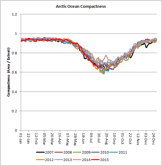
Underside melt is a big issue, but how much of an issue is it away from the ice edge once net emission exceeds net absorption? I don't think it is a coincidence that after early August compactness ceases to fall, and levels until the minimum, after which compactness rises again with the growth of new ice.
My interpretation of this is that, as Blaine noted (page 51) regards my plot of insolation and volume delta, after about the first week of August radiative melt largely ceases across the pack, and the melt continues from the edge inwards.


