6 Meter SLR, Risk Assessment for SanDiego, California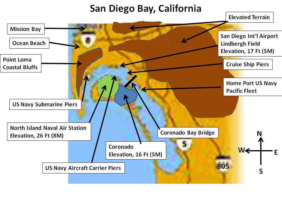
I picked San Diego for a risk assessment such as this for two reasons. The first being that unlike Miami, San Diego will not have to be entirely abandoned and with proper planning and preparations i can still remain a functioning seaport. The second reason is that I am intimately familiar with San Diego, having lived several different times, been there numerous times for both business and family reasons, in the past 50 years. I've also spent a great deal of time at all of the naval facilities.
I chose the above map because it was a free download and not cluttered with tourist attractions or too many streets and highways. My identifying markers for critical infrastructure are to the best of my recollection and I believe close enough for this discussion. The brown shaded areas are approximate and indicate areas that should not not be threatened by SLR in any scenario for an extended (centuries) period of time. I'll start by providing brief thoughts on the impact and possible courses of action for each identified risk area.
International AirportAt an elevation of only 17 feet (~5 meters), this airport will need to be relocated long before SLR reaches 6 meters. It is not at all feasible to move higher toward the more elevated terrain. It's already a difficult landing due to the surrounding mountainous terrain. Most likely place would be at Mira Mesa, about 15 miles NE of the above map. This location is currently a Marine Corps Air Station.
Coronado Bay BridgeWhen this bridge was built in 1969, the intention was to have it high enough above the water for most naval vessels to pass under. It was never intended for aircraft carriers to pass under it. At some point of SLR, naval warships might not be able to sail north under the bridge for the normal route around North Island. Then North exit/entrance to the bridge on the San Diego is elevated well above any anticipated increases in sea levels. However, as memory serve me, the southern exit/entrance on North Island arrive not far above current sea levels. Will require some re-engineering.
Headquarters US Navy Pacific FleetThe 32nd Street Naval Base is one of the largest in the world, surpassed only by Norfolk, VA in the number of personnel assigned there and the number of ships home-ported there. Many of the logistical support and training facilities can be moved nearby to higher ground. Obviously, the piers and quay walls need to be elevated. I believe I heard and Admiral say that in Norfolk they will be building double-decker piers to prepare for eventual SLR. Also, once the Coronado Bay Bridge become an obstacle to ship traffic, a shipping channel will need to be cut through that narrow spit of land going south from the village of Coronado. Also, if San Diego is going to remain a seaport, a breakwater needs to be constructed along the southern shore of North island all the way down to the southern perimeter of the bay.
North Island Naval Air StationAt 26 feet (~8 meters), much of North Island will be threatened as sea levels rise. It critical for the Navy to at least protect the berthing facilities for aircraft carriers and at least landing spaces for helicopters and short take-off and landing facilities for certain fixed wing aircraft. Is this possible? Yes. I have no idea what the costs of this are and how much acreage will eventually given back to the sea. Those are decisions far above my pay-grade.
CoronadoThis village of just over 25K population sits at an elevation of 16 feet (5 meters). In addition to some off-base housing for the Navy, there are some residential neighborhoods, some high-end restaurants, boutique hotels and the famed Hotel Del Coronado. Unfortunately, the high-end properties and tourist facilities are at the low end of the village. The powers that be must perform a cost/benefit analysis to determine how much of the village to save. Keep in mind that to protect the harbor, the western shore must have a sea wall.
Point LomaBefore I discuss the Navy's submarine facilities, I have to describe the topography of Point Loma. Someday, Point Loma may become and island although at a minimum there may be a narrow isthmus to the high elevation areas to the east. Western edge of Point Loma is a steep cliff reaching down to the ocean. Much less beach area than my drawing depicts. At the far western edge of Point Loma's peak is Cabrillo National Monument. Other than that, most of the highest elevation areas are consumed by US Naval facilities. The southern slopes toward the submarine base on the west and resort and commercial areas towards the east, while steep are sloped enough to have allowed development. Most of the residential properties on this slope will probably be safe from anticipated sea level rises. However, the commercial and much of the resort areas will be threatened by SLRs of far less than 6 meters.
US Navy Submarine PiersI've only spent 6 weeks living at this facility, however, I was going to school on the top of Point Loma. My only experience with the subsurface navy was teaching a class of technicians, that was held much farther away from the docking facilities. Since there is a relatively rapid rise fro this facility with a bedrock base, it is feasible to raise the docking facilities for the submarine fleet.
Ocean BeachThis residential/resort area is on the northwestern fringe of Point Loma going north to the canal which leads to Mission Bay. For California purposes, this has always been one of the lower rent residential areas near a beach. I can remember renting a cottage here in 1966/67 for only $95/month. I would estimate that at least 40% of this area will be lost to anticipated sea level rises. Fortunately for the richer folks, they seem to have built on the higher elevations.
Mission Bay Mission Bay is a low lying beach and resort area, that includes Sea World, that include many man-made peninsulas for either resorts or recreational activities. The northern portion of Mission Bay is heavily populated with commercial enterprises and condominiums. I would estimate that most of this area going eastward to Interstate 5 will have to be abandoned. There is no critical infrastructure here that would warrant protection from either the US Government, the State of California, the City of San Diego or influential mega-moguls. However, and this is a guess, I believe that Interstate-5 is still safe, with a much better view of the water.
Cruise PiersIf they are going to create a safe harbor for the US Navy, they might as well provide docking facilities for the cruise ships and the fishing fleet. Much of the tuna caught off of the coast of Ecuador is caught by shipping vessels home ported in San Diego.
Other Threatened AreasAdjacent to the International Airport are a number of Aerospace manufacturing companies, some of whom make the launch vehicles for NASA missions. Then there is the Convention Center which is very vulnerable to SLR, possibly well before 6 meter. Also, I have not mentioned the numerous high-rise hotels in low lying areas and the many docking facilities for luxury yachts and other pleasure craft.
Safe Facilities in the San Diego AreaScripps Institute
UC San Diego
San Diego State University
Balboa Park
San Diego Zoo
A Nostalgic Moment in San DiegoI mentioned earlier that at times I visited San Diego for family reasons, however failed to mention that my mom and dad retired in a very wonderful retirement village just east of San Diego in the mid-80s. Therefore, on those rare years that I wasn't there on business, I made frequent trips to visit my aging parents. My last trip was just 4 years ago, soon before my mom passed on. Since my mom's dimentia, at the age of 92, had reached the point where meaningful conversation was no longer possible, I decided to spend my last few hours before my flight, to give myself a farewell tour to my most memorable places in San Diego. Among them were, Seaport Village, Shelter Island, Harbor Island, Balboa Park, Old Town, Point Loma and Ocean Beach. It's not often this aging Marine sheds a tear, yet my eyes were moistened more than once that day.
When I think of that moment, I can't help but think of the 10s or 100s of thousands of San Diegans who have lived their entire lives there, building homes, building careers and raising families that will someday lose somethings that they will never be able to see or touch again.
And this is one of those fortunate cities that can be salvaged, what about the trauma and heartbreak for those who leave their cities that will never be inhabited again.


