Support the Arctic Sea Ice Forum and Blog

Author Topic: The 2016/2017 freezing season  (Read 1547147 times)

Tigertown

  • Nilas ice
  • Posts: 1678
    • View Profile
  • Liked: 24
  • Likes Given: 20
Re: The 2016/2017 freezing season
« Reply #2800 on: February 16, 2017, 04:48:20 AM »
Thick ice getting spread out and pulled toward the Fram.
"....and the appointed time came for God to bring to ruin those ruining the earth." Revelation 11:18.

Feeltheburn

  • Frazil ice
  • Posts: 214
    • View Profile
  • Liked: 14
  • Likes Given: 8
Re: The 2016/2017 freezing season
« Reply #2801 on: February 16, 2017, 05:23:46 AM »
Based on a review of NSIDC freezing trends there should be increased ice extent until about mid March, or about 4 more weeks. NSIDC reported ice extent of 14.160 km2 for Feb 14. If ice accumulation is as bad as in 2016, it should grow to about 14.5 km2. If typical, then it may grow to 14.7-14.8 km2 by mid March.
Feel The Burn!

Neven

  • Administrator
  • First-year ice
  • Posts: 9914
    • View Profile
    • Arctic Sea Ice Blog
  • Liked: 1406
  • Likes Given: 624
Re: The 2016/2017 freezing season
« Reply #2802 on: February 16, 2017, 10:33:51 AM »
I wonder what the forecast cold weather is going to do the trend line on the FDD charts.
The next great division of the world will be between people who wish to live as creatures
and people who wish to live as machines.

Wendell Berry, Life Is a Miracle

Jim Pettit

  • Nilas ice
  • Posts: 1175
    • View Profile
  • Liked: 41
  • Likes Given: 11
Re: The 2016/2017 freezing season
« Reply #2803 on: February 16, 2017, 12:44:41 PM »
Based on a review of NSIDC freezing trends there should be increased ice extent until about mid March, or about 4 more weeks. NSIDC reported ice extent of 14.160 km2 for Feb 14. If ice accumulation is as bad as in 2016, it should grow to about 14.5 km2. If typical, then it may grow to 14.7-14.8 km2 by mid March.
Depends on how one defines "typical". Based on the average behavior of the previous ten seasons, this year would max out at 14.46 km2 on 17 March. IOW, there's "typically" been an additional 300k of ice extent from this point forward--although 2012 gained an extra 644k from now until its 18 March apogee, an amount that would take 2017 to 14.8M km2. (Of course, we all remember what happened that year...)

subgeometer

  • Frazil ice
  • Posts: 362
    • View Profile
    • All in the Name of Liberty
  • Liked: 117
  • Likes Given: 71
Re: The 2016/2017 freezing season
« Reply #2804 on: February 16, 2017, 01:20:50 PM »
I wonder what the forecast cold weather is going to do the trend line on the FDD charts.
We can hope, but FDD anomaly is already greater than any other year, so it would have to get really cold for a while to even be in a better position than last year

And looking at the fragmented ice steaming through Bering St (from 14-16feb)doesn't fill me with confidence, and Chukchi doesn't look that great either - click to animate
« Last Edit: February 16, 2017, 01:26:37 PM by subgeometer »

Shared Humanity

  • Guest
Re: The 2016/2017 freezing season
« Reply #2805 on: February 16, 2017, 02:59:37 PM »
Based on the behavior of this freeze season, the single most salient characteristic of the approaching melt season will be mobility of the ice. We have seen this all winter and it will only get more obvious.

Tigertown

  • Nilas ice
  • Posts: 1678
    • View Profile
  • Liked: 24
  • Likes Given: 20
Re: The 2016/2017 freezing season
« Reply #2806 on: February 16, 2017, 03:47:52 PM »
Based on a review of NSIDC freezing trends there should be increased ice extent until about mid March, or about 4 more weeks. NSIDC reported ice extent of 14.160 km2 for Feb 14. If ice accumulation is as bad as in 2016, it should grow to about 14.5 km2. If typical, then it may grow to 14.7-14.8 km2 by mid March.

I can't see all that happening, when the forecast calls for the vortex going whacko again before the end of this month. Besides , it is not always a good thing for extent to go up, if it means the existing ice being torn to shreds.
"....and the appointed time came for God to bring to ruin those ruining the earth." Revelation 11:18.

Hyperion

  • Frazil ice
  • Posts: 375
  • Admiral Franklin of the McGillicuddy Highland Navy
    • View Profile
  • Liked: 127
  • Likes Given: 64
Re: The 2016/2017 freezing season
« Reply #2807 on: February 16, 2017, 03:55:29 PM »
It is kind of nice being on the other end for a change. I usually get accused of being the dramatic one. Others are always telling me, "it's not that bad." Well, maybe it just is.

That being the case, excellent point made by Hyperion.


Thanks Tigertown...I think  :-\ I personally like to try and step back, take a Long and philosophical viewpoint, rather than the slightly chrono-NIMBY perspective of change being "bad" because its not what we are used to. And when I see stuff about pseudo-foehns bringing down warm air from altitude to drop 19C Temps on Iceland. I immediately start to ponder whether these big global graphics like Nullschool, pretty as they might look are missing a lot of local weather effects from to small to notice on such scale turbulence effects. And how much snow interleaved with rain and super-cooled liquid water dropping thru near surface subzero  air onto that snow to form ice layers might have been going on in the early freeze season. There may have been some very warm and moist jets coming in at altitude in the cyclones even right through the freeze season that don't jump out and say "look at me!" in altitude integrated TPW. And these satellites probably only can distingush surface texture, Not whats under a few mm of shiny ice crust. ::)
Policy: The diversion of NZ aluminum production to build giant space-mirrors to melt the icecaps and destroy the foolish greed-worshiping cities of man. Thereby returning man to the sea, which he should never have left in the first place.
https://en.wikipedia.org/wiki/McGillicuddy_Serious_Party

Tigertown

  • Nilas ice
  • Posts: 1678
    • View Profile
  • Liked: 24
  • Likes Given: 20
Re: The 2016/2017 freezing season
« Reply #2808 on: February 16, 2017, 04:11:23 PM »
There is a little spitfire of a LP in the Barents today and it will move over the Kara tomorrow. It is at 975 hpa today and causing 9 meter waves.

Also,  Fram export will go supersonic around the 20th and 21st. If the broken up ice can bond together before then, it might stand a chance to resist. We'll see.
"....and the appointed time came for God to bring to ruin those ruining the earth." Revelation 11:18.

Hyperion

  • Frazil ice
  • Posts: 375
  • Admiral Franklin of the McGillicuddy Highland Navy
    • View Profile
  • Liked: 127
  • Likes Given: 64
Re: The 2016/2017 freezing season
« Reply #2809 on: February 16, 2017, 04:22:29 PM »
Based on the behavior of this freeze season, the single most salient characteristic of the approaching melt season will be mobility of the ice. We have seen this all winter and it will only get more obvious.

The Atmospheric weirdness globally is whats fascinating me most. Which is I guess the Cause and in no small part also the symptom. The record drift velocities and lack of cohesion must be drawing up lots of heat from the warm Salty layers. The thermal transfer across the sub mixed surface layer halopause must be far larger than normal. Relative motion and increased surface area from waving both have potential for big conduction enhancements without even looking at mixing.
The nullschool imaging like this:
https://earth.nullschool.net/#current/wind/isobaric/250hPa/overlay=mean_sea_level_pressure/atlantis=-36.90,182.05,130/loc=-129.803,-65.515
(not sure how to get that visible)
looks for all the world to me like a near collapse of polar and hadley cells in both hemispheres, with the Ferrel cells setting up as a single cell per hemisphere circulation. And the 250hpa cross equator flows feeding sthrn summer heat into the arctic winter over the pacific and africa, and the indian ocean returns dropping cold back into our single mid latitude jet whirlpool intrigue me. I've always thought that a single cell hadley was the only single cell dynamic possible. :-\  Though as long as there's much ice on Antarctica, I expect still it is in sthrn winter. Maybee hypertropie cyclones feeding big Antarctic low midwinter? :o

<a href="https://earth.nullschool.net/#current/wind/isobaric/250hPa/overlay=mean_sea_level_pressure/atlantis=-36.90,182.05,130/loc=-129.803,-65.515" target="_blank" rel="noopener noreferrer" class="bbc_link bbc_flash_disabled new_win">https://earth.nullschool.net/#current/wind/isobaric/250hPa/overlay=mean_sea_level_pressure/atlantis=-36.90,182.05,130/loc=-129.803,-65.515</a>
Policy: The diversion of NZ aluminum production to build giant space-mirrors to melt the icecaps and destroy the foolish greed-worshiping cities of man. Thereby returning man to the sea, which he should never have left in the first place.
https://en.wikipedia.org/wiki/McGillicuddy_Serious_Party

Thomas Barlow

  • Guest
Re: The 2016/2017 freezing season
« Reply #2810 on: February 16, 2017, 04:53:44 PM »
Is this unusual?
Nares Strait seems like a lot of open water?
« Last Edit: February 16, 2017, 05:36:17 PM by Thomas Barlow »

Pmt111500

  • Guest
Re: The 2016/2017 freezing season
« Reply #2811 on: February 16, 2017, 05:19:26 PM »
Quote
arth.nullschool.net/#current/wind/isobaric/250hPa/overlay=mean_sea_level_pressure/atlantis=-36.90,182.05,130/loc=-129.803,-65.515
(not sure how to get that visible)

Take a screenshot, save on drive by a name of your choice, upload... Current images change over time so not applicable here... I think in early days of the forum it was possible and caused regular confusion since the image wasn't anymore what it was supposed to be...

jdallen

  • Young ice
  • Posts: 3440
    • View Profile
  • Liked: 698
  • Likes Given: 256
Re: The 2016/2017 freezing season
« Reply #2812 on: February 16, 2017, 05:29:22 PM »
I wonder what the forecast cold weather is going to do the trend line on the FDD charts.
We can hope, but FDD anomaly is already greater than any other year, so it would have to get really cold for a while to even be in a better position than last year

And looking at the fragmented ice steaming through Bering St (from 14-16feb)doesn't fill me with confidence, and Chukchi doesn't look that great either - click to animate
Presuming we manage to return to "normal " temperatures, between now and day 100 (about where the DMI average starts up and passes this season's typical temps), the best we can hope for is 10-20 cm of thickening in existing ice, and about 50cm of ice where open water freezes over.  There simply isn't enough time to dump enough heat.

Keep in mind also the thermal balance is already tipping away from ice formation on the Pacific side of the basin, so past about day 60, most of that ice formation will be restricted to 80N and higher.  New extent on the Pacific side will either be from export, or remain very thin  and start disappearing very rapidly in 2-3 weeks. Another 2 weeks or so past that, and substantial sunlight returns to the Kara and Barentz where the already open water or thin dispersed ice will begin soaking up sunlight 6-8 weeks earlier than was normal.

This space for Rent.

Tigertown

  • Nilas ice
  • Posts: 1678
    • View Profile
  • Liked: 24
  • Likes Given: 20
Re: The 2016/2017 freezing season
« Reply #2813 on: February 16, 2017, 05:40:27 PM »
@jdallen
Add to that, as aslan mentioned, the vortex will only remain strong enough to keep the heat out of the Arctic for a brief time longer. A good chance the next SSW is the SFW for this "freezing" season.
"....and the appointed time came for God to bring to ruin those ruining the earth." Revelation 11:18.

ktonine

  • Frazil ice
  • Posts: 363
    • View Profile
  • Liked: 0
  • Likes Given: 0
Re: The 2016/2017 freezing season
« Reply #2814 on: February 16, 2017, 05:47:14 PM »


Jim Williams

  • Frazil ice
  • Posts: 398
    • View Profile
  • Liked: 1
  • Likes Given: 0
Re: The 2016/2017 freezing season
« Reply #2815 on: February 16, 2017, 05:51:02 PM »
I wonder what the forecast cold weather is going to do the trend line on the FDD charts.
We can hope, but FDD anomaly is already greater than any other year, so it would have to get really cold for a while to even be in a better position than last year

And looking at the fragmented ice steaming through Bering St (from 14-16feb)doesn't fill me with confidence, and Chukchi doesn't look that great either - click to animate
Presuming we manage to return to "normal " temperatures, between now and day 100 (about where the DMI average starts up and passes this season's typical temps), the best we can hope for is 10-20 cm of thickening in existing ice, and about 50cm of ice where open water freezes over.  There simply isn't enough time to dump enough heat.

Keep in mind also the thermal balance is already tipping away from ice formation on the Pacific side of the basin, so past about day 60, most of that ice formation will be restricted to 80N and higher.  New extent on the Pacific side will either be from export, or remain very thin  and start disappearing very rapidly in 2-3 weeks. Another 2 weeks or so past that, and substantial sunlight returns to the Kara and Barentz where the already open water or thin dispersed ice will begin soaking up sunlight 6-8 weeks earlier than was normal.
I'm tempted to start a counting the days thread, but I think you'd be much better at it than me.

Winter is running out of time.

Jim Williams

  • Frazil ice
  • Posts: 398
    • View Profile
  • Liked: 1
  • Likes Given: 0
Re: The 2016/2017 freezing season
« Reply #2816 on: February 16, 2017, 06:07:38 PM »
We can celebrate ten days of relative quietness in the Arctic Ocean. The impression is clear that  in this overheated environment, any kind of agitation represents net loss of ice. Quietness is the only thing that seems to cure the Arctic ice. A flat and persistent anticyclone. A cold and persistent storm. For reasons hard to describe, any dynamics is bad. And look, over a year now, this quietness seems to be more the exception than the norm.
Um....You telling the Arctic to practice Zen?  I doubt it will listen.

Of course, that same anticyclone in mid Summer is Ice Death.

romett1

  • Frazil ice
  • Posts: 286
    • View Profile
  • Liked: 48
  • Likes Given: 2
Re: The 2016/2017 freezing season
« Reply #2817 on: February 16, 2017, 06:11:32 PM »
There is a little spitfire of a LP in the Barents today and it will move over the Kara tomorrow. It is at 975 hpa today and causing 9 meter waves.

Also,  Fram export will go supersonic around the 20th and 21st. If the broken up ice can bond together before then, it might stand a chance to resist. We'll see.

Seems like Feb 20 - Feb 23 we have lot of wind supporting export (Climate Reanalyzer). And wind over this kind of mobile ice. http://ocean.dmi.dk/arctic/nord.uk.php

Lord M Vader

  • Nilas ice
  • Posts: 1413
    • View Profile
  • Liked: 67
  • Likes Given: 41
Re: The 2016/2017 freezing season
« Reply #2818 on: February 16, 2017, 08:03:45 PM »
Wrt temp +80N, we have at most 3 weeks until the average temp starts to ramp up. Yes, Arctic basin will see cold weather for the next 10 days but given all those bombcyclones that have rolled into the Arctic since fall we have to consider the isolation effect from the snow. Even a thin snow cover onto the ice isolates. Yes, we will see thickening but the question is how much until the temps are rising?

And is the thickening more valuable compared ti the eventually demise of the +4m thick ice north of Greenland?

Another thing of concern is whether we will see an early opening of the Beaufort Sea like last year given how weak that ice should be. ECMWF 12z op run foresees a posible 1040 hpa anticyclone by D10 in this area. And also a new surge of moist air from the Pacific by that time.. If the Arctic is fortune it will dodge that bullet.

Jim Williams

  • Frazil ice
  • Posts: 398
    • View Profile
  • Liked: 1
  • Likes Given: 0
Re: The 2016/2017 freezing season
« Reply #2819 on: February 16, 2017, 11:56:01 PM »
Wrt temp +80N, we have at most 3 weeks until the average temp starts to ramp up. Yes, Arctic basin will see cold weather for the next 10 days but given all those bombcyclones that have rolled into the Arctic since fall we have to consider the isolation effect from the snow. Even a thin snow cover onto the ice isolates. Yes, we will see thickening but the question is how much until the temps are rising?

And is the thickening more valuable compared ti the eventually demise of the +4m thick ice north of Greenland?

Another thing of concern is whether we will see an early opening of the Beaufort Sea like last year given how weak that ice should be. ECMWF 12z op run foresees a posible 1040 hpa anticyclone by D10 in this area. And also a new surge of moist air from the Pacific by that time.. If the Arctic is fortune it will dodge that bullet.
That "at most three weeks" is why I think we need a "counting the days" thread.  If ever there was a year where we were on the cusp and not ready to know which way it falls...this is the year.

peterlvmeng

  • Frazil ice
  • Posts: 146
    • View Profile
  • Liked: 36
  • Likes Given: 9
Re: The 2016/2017 freezing season
« Reply #2820 on: February 17, 2017, 04:01:53 AM »
SSW is coming and polar vortex is crashed. The sea ice recovery is disrupted after 7 days. No good. I wonder if accompanied with rapid shrinking of snow cover area in the mid-latitude.


oren

  • Moderator
  • Multi-year ice
  • Posts: 10084
    • View Profile
  • Liked: 3800
  • Likes Given: 4381
Re: The 2016/2017 freezing season
« Reply #2821 on: February 17, 2017, 07:45:06 AM »
Is this unusual?
Nares Strait seems like a lot of open water?
For more details take a look at the Nares Strait thread discussion from the end of January and forward.
http://forum.arctic-sea-ice.net/index.php/topic,176.900.html
An ice "arch" formed in the Lincoln Sea about two weeks ago (usual for this time of year) and stopped the drift of old thick ice down the strait. Nares is still filled with new ice due to the prevailing low temps, but the strong surface current through the strait sometimes causes open water to appear before freezing back. Note sometimes there is also another "arch" or "bridge" in the south in Kane Basin, but this year it hasn't formed (yet?).
For better resolution that shows the thin ice go to DMI and click on the Sentinel images.
http://ocean.dmi.dk/arctic/kane.uk.php
http://ocean.dmi.dk/arctic/lincoln.uk.php

meddoc

  • Frazil ice
  • Posts: 264
    • View Profile
  • Liked: 12
  • Likes Given: 0
Re: The 2016/2017 freezing season
« Reply #2822 on: February 17, 2017, 12:52:06 PM »
SSW is coming and polar vortex is crashed. The sea ice recovery is disrupted after 7 days. No good. I wonder if accompanied with rapid shrinking of snow cover area in the mid-latitude.

The Vortex is just a mere Shade of itself- even compared with the last two "bad" Years.
SSW subs are finishing it off. Menwhile the fog over C- Europe shows the temperature inversions which are caused by those cold, displaced normally high altitude airmasses.

Geopolitics is also in high gear- the dauered- hair Guy has been blackmailed not to improve Relations with Russia...

Thomas Barlow

  • Guest
Re: The 2016/2017 freezing season
« Reply #2823 on: February 17, 2017, 03:17:21 PM »
 
Quote
Oren: "For more details take a look at the Nares Strait thread discussion from the end of January and forward...


Thanks!

Tigertown

  • Nilas ice
  • Posts: 1678
    • View Profile
  • Liked: 24
  • Likes Given: 20
Re: The 2016/2017 freezing season
« Reply #2824 on: February 17, 2017, 03:35:27 PM »
The ten day forecast for the Polar Vortex.
"....and the appointed time came for God to bring to ruin those ruining the earth." Revelation 11:18.

DrTskoul

  • Nilas ice
  • Posts: 1455
    • View Profile
  • Liked: 210
  • Likes Given: 60
Re: The 2016/2017 freezing season
« Reply #2825 on: February 17, 2017, 03:45:11 PM »
Head on collision....

peterlvmeng

  • Frazil ice
  • Posts: 146
    • View Profile
  • Liked: 36
  • Likes Given: 9
Re: The 2016/2017 freezing season
« Reply #2826 on: February 17, 2017, 03:47:31 PM »
SSW is coming and polar vortex is crashed. The sea ice recovery is disrupted after 7 days. No good. I wonder if accompanied with rapid shrinking of snow cover area in the mid-latitude.

The Vortex is just a mere Shade of itself- even compared with the last two "bad" Years.
SSW subs are finishing it off. Menwhile the fog over C- Europe shows the temperature inversions which are caused by those cold, displaced normally high altitude airmasses.

Geopolitics is also in high gear- the dauered- hair Guy has been blackmailed not to improve Relations with Russia...

Thanks meddoc, I am quite interested to see the condition of sea ice this spring.

peterlvmeng

  • Frazil ice
  • Posts: 146
    • View Profile
  • Liked: 36
  • Likes Given: 9
Re: The 2016/2017 freezing season
« Reply #2827 on: February 17, 2017, 03:49:17 PM »
The ten day forecast for the Polar Vortex.


Thanks, Tigertown. I wonder how many days will this SSW propagate to the troposphere.

Gray-Wolf

  • Grease ice
  • Posts: 950
    • View Profile
  • Liked: 138
  • Likes Given: 463
Re: The 2016/2017 freezing season
« Reply #2828 on: February 17, 2017, 03:56:49 PM »
As far as snow loss is concerned will we see the 'early snow' that fell in west Siberia disappear at its normal time or will it linger and impact local temps downward this spring?
KOYAANISQATSI

ko.yaa.nis.katsi (from the Hopi language), n. 1. crazy life. 2. life in turmoil. 3. life disintegrating. 4. life out of balance. 5. a state of life that calls for another way of living.
 
VIRESCIT VULNERE VIRTUS

Tigertown

  • Nilas ice
  • Posts: 1678
    • View Profile
  • Liked: 24
  • Likes Given: 20
Re: The 2016/2017 freezing season
« Reply #2829 on: February 17, 2017, 04:32:13 PM »
The ten day forecast for the Polar Vortex.


Thanks, Tigertown. I wonder how many days will this SSW propagate to the troposphere.

aslan mentioned a few days back that the upcoming event appears according to the forecast to be the Stratospheric Final Warming for the NH this year. I am no expert on the matter, but feel that this is very significant and therefore watching intently. If the forecast plays out, this will be the earliest ever SFW. aslan had a link to this chart below.

"....and the appointed time came for God to bring to ruin those ruining the earth." Revelation 11:18.

Gray-Wolf

  • Grease ice
  • Posts: 950
    • View Profile
  • Liked: 138
  • Likes Given: 463
Re: The 2016/2017 freezing season
« Reply #2830 on: February 17, 2017, 05:18:04 PM »
Antarctica also saw an early final warming at the end of its winter season? I imagine the Strat is far less complex in its operations than the Trop below and ,as such, I think it can be viewed as a single unit unlike the trop which is broken down into hemisphere and cells?

Should we see an unusual impact hitting the strat then I tend toward thinking it would reverberate around the whole of the strat impacting both regions? Only in Autumn can we see both polar vortex and this year the collapse of the polar vortex was occurring as the final warming was occurring in the southern hemisphere . Coincidence or more evidence for the Strat behaving oddly over recent years?


KOYAANISQATSI

ko.yaa.nis.katsi (from the Hopi language), n. 1. crazy life. 2. life in turmoil. 3. life disintegrating. 4. life out of balance. 5. a state of life that calls for another way of living.
 
VIRESCIT VULNERE VIRTUS

aslan

  • Frazil ice
  • Posts: 226
    • View Profile
  • Liked: 175
  • Likes Given: 0
Re: The 2016/2017 freezing season
« Reply #2831 on: February 17, 2017, 05:25:15 PM »
It is from an ozone project at NASA :

https://ozonewatch.gsfc.nasa.gov/meteorology/NH.html

And for SH :

https://ozonewatch.gsfc.nasa.gov/meteorology/

Plot shows forecast up to 192h. The fat of the SFW is still a tad after, in a longer range. The important thing is to look for a wind reversal, ie. zonal wind becoming negatif. If easterlies take place in stratosphere, wave guide and wave propagation are heavily disrupted. So there is, in this peticular case, a kind of razor thin threshold (which is an uncommon thing usually in atmospheric science  :D ). This can promote the building of "warm" high pressure other Arctic, like GFS is showing (but only as an example, an illustration. GFS at 348h in troposphere is too wacky for trying to even pin down a broad region from where these highs can come from...) :


One other thing is the restless activity of waves in stratosphere. At this time of higher, Sun is not yet shining over the PV and PV should be able to reestablish, but GFS don't let him this possibility. Its best foe, IFS the european, goes only to 240h and so only show the incipient SSW and still not the downward propagation of its consequences in troposphere. But currently, given its outputs, it is quite likely it will follow the GFS idea.

On the opposite side, an early SFW could promote cold weather other continents, helping the snow which is already under assault:


But I am not really convinced. For the moment, I still don't have a clear idea of how the month of March could unfold, but at least I am not optimistic. Currently, given tropical convection and stratosphere activity, I tend to think that cold in troposphere wil be displaced to a pool circumscribe to Canada and Estern Siberia, but weather is weird. If we go for the earliest SFW recorded, by definition we have no precedent, leaving us to guess more than to forecast. It is difficult to find clues in these marshes.

aslan

  • Frazil ice
  • Posts: 226
    • View Profile
  • Liked: 175
  • Likes Given: 0
Re: The 2016/2017 freezing season
« Reply #2832 on: February 17, 2017, 05:40:25 PM »
Antarctica also saw an early final warming at the end of its winter season? I imagine the Strat is far less complex in its operations than the Trop below and ,as such, I think it can be viewed as a single unit unlike the trop which is broken down into hemisphere and cells?

Nein Pamina. Early SFWs, of a dynamic kind, are specific to NH due to the wave activity, caused by the mountains in the flow. In NH winter, Rossby waves (wavenumber up to 8 - 9) are an important factor. I will search to retrieve a resource about this subject, I will post when I find it on Internet :p

The Rockies and Tibetan plateau disrupt the flow, and to a lesser extent Apalachians and Ural. In NH, there is two kind of SFW. One, early (March - April), and dynamically forced. This kind of SFW often brings an AO- pattern to simplify during the Spring (but it is really to simplify with an axe). On the other hand, there is a radiatively forced SFW. When the Sun rises, the ozone-rich, polar, region sucks in energy until the PV disappears. This king of SFW is often associated with an AO+ pattern during Spring (still, to simplify with an axe :D ). In SH, there is no such thing as wave activity. Flow around 40Ā°S - 50Ā°S  is away from any landmasses and can flow regularly. There is one occurrence of a dynamical SFW in the SH, in 2002, but this extremely rare. Often, it is a radiative SFW occurring around November - December -so very very lately-.

http://journals.ametsoc.org/doi/pdf/10.1175/JAS3979.1

http://journals.ametsoc.org/doi/pdf/10.1175/JCLI3907.1

http://journals.ametsoc.org/doi/pdf/10.1175/JAS3981.1

ftp://acd-ext.gsfc.nasa.gov/pub/papers/newman/o3_sh_02/2002_o3_hole.pdf

http://www.cpc.ncep.noaa.gov/products/outreach/proceedings/cdw29_proceedings/black.ppt

You can search for this scientists, Baldwin, McDaniel, Black. There is other names, but this three are often involved.


Quote
Should we see an unusual impact hitting the strat then I tend toward thinking it would reverberate around the whole of the strat impacting both regions? Only in Autumn can we see both polar vortex and this year the collapse of the polar vortex was occurring as the final warming was occurring in the southern hemisphere . Coincidence or more evidence for the Strat behaving oddly over recent years?

I don't know. QBO was probably disrupted in part due to the unusual behavior of the polar vortex in NH last year, but here you are at the borders of the knowledge (and of the madness I want to say).
« Last Edit: February 17, 2017, 05:47:08 PM by aslan »

Gray-Wolf

  • Grease ice
  • Posts: 950
    • View Profile
  • Liked: 138
  • Likes Given: 463
Re: The 2016/2017 freezing season
« Reply #2833 on: February 17, 2017, 06:15:03 PM »
Thanks aslan!

So it is all down to WACCy Jet stream launching of available launch pads an up into the Strat?

With low Sea ice looking like it has broken the relationship between QBO and polar Jet ( no longer need QBO e to send the jet loopy?) we should expect a messier picture over the basin with rogue jet limbs pushing into the Strat and either displacing it or disrupting it completely ( so allowing warm air to flood the basin.

Does anybody see an end point to this or are we just winding up to some unforeseen crescendo ?
KOYAANISQATSI

ko.yaa.nis.katsi (from the Hopi language), n. 1. crazy life. 2. life in turmoil. 3. life disintegrating. 4. life out of balance. 5. a state of life that calls for another way of living.
 
VIRESCIT VULNERE VIRTUS

magnamentis

  • Guest
Re: The 2016/2017 freezing season
« Reply #2834 on: February 17, 2017, 06:42:04 PM »
Thanks aslan!

So it is all down to WACCy Jet stream launching of available launch pads an up into the Strat?

With low Sea ice looking like it has broken the relationship between QBO and polar Jet ( no longer need QBO e to send the jet loopy?) we should expect a messier picture over the basin with rogue jet limbs pushing into the Strat and either displacing it or disrupting it completely ( so allowing warm air to flood the basin.

Does anybody see an end point to this or are we just winding up to some unforeseen crescendo ?

as to all down to i'd oppose that statement that it's all down to one single factor while there indeed is a lot to that correlation desribed by Aslan IMO. it's just not that simple IMHO.

as to the other question, i think nobody really knows, last but not least due to the number of factory again. the only think one can (and should) do is watch out for new patterns that can be used for new models, fearing that once we understand what's going on now (in detail) the new understanding will have become obsolete because the process won't stop here.

enjoy a nice weekend @all and thanks for the daily pleasure to read through all your contributions :-) :D

aslan

  • Frazil ice
  • Posts: 226
    • View Profile
  • Liked: 175
  • Likes Given: 0
Re: The 2016/2017 freezing season
« Reply #2835 on: February 17, 2017, 07:13:54 PM »
Yeah, there is a study going with you :

http://www.nature.com/articles/ncomms5646

The figure I was searching (sorry, it is a bad scan, I was not able to find a fun version on Internet) from Peixoto  & Oort, 1992 (thanks D. for helping me with the reference...) : https://www.amazon.fr/Physics-Climate-Jose-P-Peixoto/dp/0883187124 (I think it is quite good also to stun people, in a literal and metaphorical way of meaning  :D )


Meridional transport of heat (sensible heat, in degree) from a/ total transport b/ transitory circulation (baroclinic lows in plain english) c/ stationary circulation (planetary waves so) and d/axisymetric circulation (Hadley cells, symmetric around an axis). Red is annual, blue is summer, yellow is winter. Axis scale change from one diagramm to the other.

And the same for water vapor (showing indirectly latent heat from water vapor condensing / evaporating) :


There is quite a bit spike in NH associated with the planetary waves (non symmetric stationary circulation). This is from the 90s but planetary waves have always been a factor in NH climatology. This waves are the reasons for the frequent SSW in winter (about one every two winters) and dynamical, early SFWs. With climate change and jets going wacko, stratosphere could be more often disrupted. There is also another factor, highlighted by Judah Cohen. Increased snow cover in Autumn (especially October and November) associated with the increase in moisture, can also disrupted the polar vortex. Increased snow reinforce the Siberian High, with the effect to enhance the planetary wave 1. And strong wave 1 generally leads to a broken VP during the winter. There is a review from Cohen of this subject (but I must confess I don't have read it wholly ^^" ):

http://web.mit.edu/jlcohen/www/papers/Cohenetal_NGeo14.pdf

This is an interresting area of research, but it is also a nightmare to find some dry ground in theses marshes.

After that, there is also of course others factors. The review has also a word or two about the tropics, without going through it in details (it is not a full lecture about the climate :D ). But yet, the tropical convection is also a factor for the stratosphere. QBO is primarily driven by propagation of waves from tropics, and currently there is no consensus about the evolution of the QBO under the hypothesis of a global warming. Some are saying that QBO will oscillate more rapidly, some more slowly, some are saying no change, or etc... And in the same time we have the QBO making some crazy stuffs. So, for this subject, it is anyone guess.

And last but not least, ozone depletion is also a factor.

Gray-Wolf

  • Grease ice
  • Posts: 950
    • View Profile
  • Liked: 138
  • Likes Given: 463
Re: The 2016/2017 freezing season
« Reply #2836 on: February 17, 2017, 07:24:19 PM »
This years uptick in sightings of folk of polar Stratospheric clouds also has me wondering. you need a really cold strat for them to form but you also need moisture up in the strat?

PSC's are also important in the destruction of Ozone and so , just as the hole over Antarctica appears to be mending?

The ozone hole over the UK , this time last year, is an example of what increased moisture/cooler upper strat will mean to the hemisphere?

To me it appears that the extra energy that increases in GHG's have placed into the climate system is impacting all layers of the atmosphere?
KOYAANISQATSI

ko.yaa.nis.katsi (from the Hopi language), n. 1. crazy life. 2. life in turmoil. 3. life disintegrating. 4. life out of balance. 5. a state of life that calls for another way of living.
 
VIRESCIT VULNERE VIRTUS

bairgon

  • Frazil ice
  • Posts: 133
    • View Profile
  • Liked: 15
  • Likes Given: 0
Re: The 2016/2017 freezing season
« Reply #2837 on: February 17, 2017, 07:27:10 PM »
The bug in EOSDIS squashed palette links has been fixed (quite quickly after I reported it), allowing easy sharing of URLs like https://worldview.earthdata.nasa.gov/?p=arctic&l=Land_Mask,MODIS_Aqua_Brightness_Temp_Band31_Night(palette=rainbow_1,min=230.6,max=280.6,squash)&t=2017-02-16&z=3&v=-346200.80363929644,-1288049.579851776,1619879.1963607036,-279409.5798517759&ab=off&as=2016-12-15&ae=2016-12-22&av=3&al=true . Previously the max limit for the palette was not loaded from the URL.

Image is below - from 16th Feb, palette squashed to 230 to 280K.

aslan

  • Frazil ice
  • Posts: 226
    • View Profile
  • Liked: 175
  • Likes Given: 0
Re: The 2016/2017 freezing season
« Reply #2838 on: February 17, 2017, 08:19:26 PM »
This years uptick in sightings of folk of polar Stratospheric clouds also has me wondering. you need a really cold strat for them to form but you also need moisture up in the strat?

PSC's are also important in the destruction of Ozone and so , just as the hole over Antarctica appears to be mending?

The ozone hole over the UK , this time last year, is an example of what increased moisture/cooler upper strat will mean to the hemisphere?

To me it appears that the extra energy that increases in GHG's have placed into the climate system is impacting all layers of the atmosphere?

I am pretty confident we are totally off-topic xD but here we go.

There is a circulation of ozone in stratosphere, called the Brewer-Dobson circulation (Dobson like the Dobson Unit, a DU, it is the same guy). I don't know everything about this subject so I will try to stick with what I am sure. Ozone is mainly produced in tropical stratosphere, due to UVs radiations. It is also UVs radiations which destroy naturally the ozone. The Brewer-Dobson circulation mixes this ozone. In the tropics, in the stratosphere, there is upwelling. And near the poles, especially in winter hemisphere, there is downwelling. Ozone concentration is thus lowered in tropics, and raised in extratropics. This is the reason for the annual cycle of ozone in the stratosphere of the Northern Hemisphere :

https://ozonewatch.gsfc.nasa.gov/meteorology/figures/merra/ozone/toms_capn_2016_omi+merra.pdf

Brewer-Dobson circulation transport ozone from tropics to poles, but especially in winter, and the ozone being not destroyed due to the low sun, ozone accumulates.

But in the same time, the polar vortex isolated cold air of the stratosphere, away from the sun rays.

This is even more true for the Southern Hemisphere, where there is no planetary waves to disrupt the PV. So the polar stratosphere is isolated and cool down a lot. Molecules like CFC etc... responsible of the ozone depletion accumulate in the vortex, destroying the ozone. The very cool stratosphere in SH, with stratospheric polar clouds, explain why ozone depletion is mainly occuring in SH. We can thus this a broken seasonal cycle, with a first minimum in boreal summer (Feb.) then the start of a rise, and after a big crash when PV builb up:

https://ozonewatch.gsfc.nasa.gov/meteorology/figures/merra/ozone/toms_mins_2016_omi+merra.pdf

There is a feedback loop in this. Stratosphere is warm by the Sun energy sucked up by the ozone. So if there is less ozone, the PV is colder during the Spring, so the PV is stronger and last longer (some SFW in Southern Hemisphere lately occurred even in boreal summer...), so the ozone depletion is reinforced, etc...

Ozone depletion is also observed in NH when the polar vortex is strong. The biggest hole was reached during the winter 2011 I think:

https://ozonewatch.gsfc.nasa.gov/Scripts/big_image.php?date=2011-03-15&hem=N
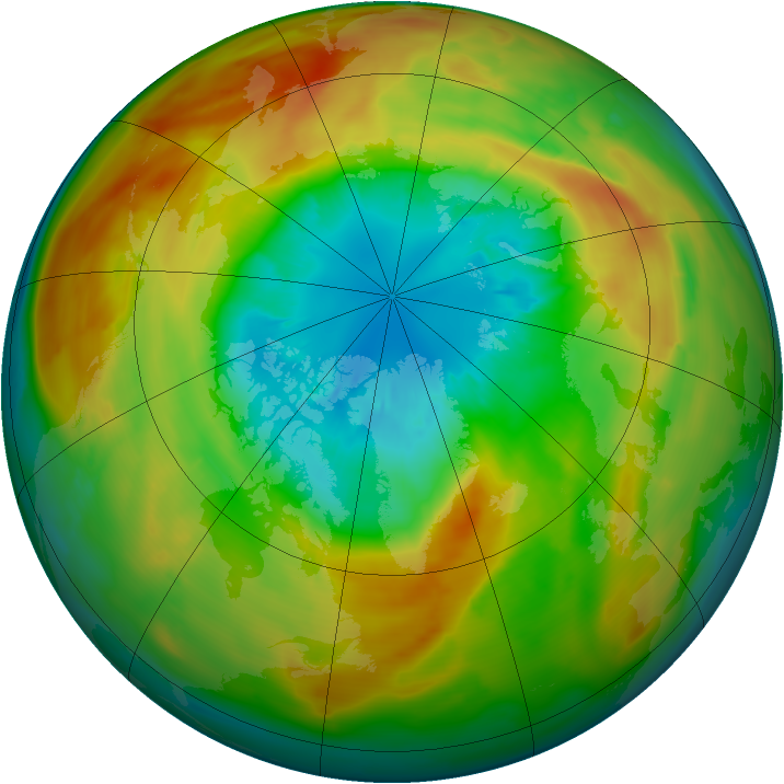


But polar vortex being weaker and warmer in Northern Hemisphere, ozone depletion is weaker and is not producing a big hole like in SH.
There is at least one positive point with the polar vortex being shaken, it avoid us to be irradiated and burnt  :D

With global warming in troposphere, stratosphere is cooling -and it is a big fingerprint of greenhouses being at work-. This year, despite the disturbed PV, it was cold in stratosphere, and sometimes even record cold:


http://www.cpc.ncep.noaa.gov/products/stratosphere/temperature/

In theory, stratosphere should moistens a bit also, with a greater input from the tropical convection (Cbs overshoot reaching the lower stratosphre). But here is uncertainity regarding what is really going on with the stratospheric water vapor :

http://onlinelibrary.wiley.com/doi/10.1002/2014JD021712/full

http://onlinelibrary.wiley.com/doi/10.1002/2014JD021712/full

http://www.pnas.org/content/110/45/18087.full

www.sciencemag.org/cgi/content/abstract/science.1182488

It exists some theories about a feedback from polar clouds, in equable climates especially, but also in a not so distance future. For example :

http://www.nature.com/nature/journal/v357/n6376/abs/357320a0.html

http://onlinelibrary.wiley.com/doi/10.1029/98GL02492/pdf

http://climate.fas.harvard.edu/files/climate/files/huber_cpd-7-241-2011-print.pdf (there is a list of papers about PSCs at the beginning)

Stratospheric clouds are perhaps set to become more frequent, but observations are really not conclusive for now.

Quote
To me it appears that the extra energy that increases in GHG's have placed into the climate system is impacting all layers of the atmosphere?

Yeah, no doubt, we are totally messing with the whole atmosphere and not only troposphere.

P.S: If you are british, in the end of March 2011 it was even worst actually...
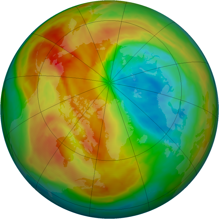
« Last Edit: February 17, 2017, 08:26:48 PM by aslan »

Neven

  • Administrator
  • First-year ice
  • Posts: 9914
    • View Profile
    • Arctic Sea Ice Blog
  • Liked: 1406
  • Likes Given: 624
Re: The 2016/2017 freezing season
« Reply #2839 on: February 17, 2017, 09:39:58 PM »
That's all very interesting off-topic (more or less), but let's not overdo it. And again, it's a shame that all the energy spent to write down this information, gets lost. I'm sure there's a good SSW thread out there.
The next great division of the world will be between people who wish to live as creatures
and people who wish to live as machines.

Wendell Berry, Life Is a Miracle

Gray-Wolf

  • Grease ice
  • Posts: 950
    • View Profile
  • Liked: 138
  • Likes Given: 463
Re: The 2016/2017 freezing season
« Reply #2840 on: February 17, 2017, 10:36:35 PM »
We were already on it Neven and its all cleaned up now! We're learning..... honest! :)
KOYAANISQATSI

ko.yaa.nis.katsi (from the Hopi language), n. 1. crazy life. 2. life in turmoil. 3. life disintegrating. 4. life out of balance. 5. a state of life that calls for another way of living.
 
VIRESCIT VULNERE VIRTUS

be cause

  • Young ice
  • Posts: 2606
    • View Profile
  • Liked: 1102
  • Likes Given: 1166
Re: The 2016/2017 freezing season
« Reply #2841 on: February 18, 2017, 01:17:48 AM »
The Dmi's DMT 80N+ have fallen to their lowest for over a year ! . Still nearly 5'C above 'normal' . I had forecast that they would stay above normal this winter . I will stick with my prediction :)
We live in a Quantum universe . Do you live like you do ?

Tigertown

  • Nilas ice
  • Posts: 1678
    • View Profile
  • Liked: 24
  • Likes Given: 20
Re: The 2016/2017 freezing season
« Reply #2842 on: February 18, 2017, 07:13:07 AM »
Concentration and volume have been on the upswing for a couple of days now.
"....and the appointed time came for God to bring to ruin those ruining the earth." Revelation 11:18.

epiphyte

  • Frazil ice
  • Posts: 387
    • View Profile
  • Liked: 22
  • Likes Given: 21
Re: The 2016/2017 freezing season
« Reply #2843 on: February 18, 2017, 07:55:04 AM »
Vaguely on topic, I hope... 62H, 41L degrees F here in Minneapolis today, beat the previous record by 8 degrees. Normal is 30/14. Snow cover is gone - a month early.

(other than in my front yard, of course, which is on a north facing slope on top of a 6x200 foot  geothermal heat-exchanger, which has been chilling it down all winter. What can I say? I don't like mowing the lawn.)

Lord M Vader

  • Nilas ice
  • Posts: 1413
    • View Profile
  • Liked: 67
  • Likes Given: 41
Re: The 2016/2017 freezing season
« Reply #2844 on: February 18, 2017, 10:32:06 AM »
According to DMIs volume graph, there have been a significant uptick in volume during the last few days.

But I must admit that future refreezing seasons will be just as interesting as the melting seasons. The quick warming wintertime will unevitably lead to a much lower volume growth and easier melting seasons. What we are seeing now is just a glimpse of the future when winters are going to be even warmer. Next big El NiƱo might be devastating to the sea ice.


JayW

  • Grease ice
  • Posts: 607
    • View Profile
  • Liked: 230
  • Likes Given: 295
Re: The 2016/2017 freezing season
« Reply #2845 on: February 18, 2017, 12:34:08 PM »
Feb 13-18,  115 hour loop

Pretty good flow south through the Bering Strait.

Imagery courtesy of the University of Alaska at Fairbanks
 I05 band. Alaska at bottom center

"To defy the laws of tradition, is a crusade only of the brave" - Les Claypool

gerontocrat

  • Multi-year ice
  • Posts: 22821
    • View Profile
  • Liked: 5671
  • Likes Given: 71
Re: The 2016/2017 freezing season
« Reply #2846 on: February 18, 2017, 12:53:58 PM »
Weather-forecast.com wind graphics has strongish northerlies down the Fram 21-24 Feb. Then starting 26 Feb southerlies developing into a wopper up to N Pole by end Feb 28th.
"I wasn't expecting that quite so soon" kiwichick16
"Para a Causa do Povo a Luta Continua!"
"And that's all I'm going to say about that". Forrest Gump
"Damn, I wanted to see what happened next" (Epitaph)

seaicesailor

  • Guest
Re: The 2016/2017 freezing season
« Reply #2847 on: February 18, 2017, 01:27:39 PM »
Another view of the debris left behind by the powerful storm that passed over Fram Strait a few days ago (worldview Terra Brightness). https://goo.gl/G0TMbz
First frame is Jan 31 before the storm, then clouds do not allow clear images until Feb 13. Last five frames show transport of the MYI blocks from Feb 13 to Feb 17.
I agree this ice will be moved quite easily, the announced winds will push all this ice to the Atlantic Ocean.

A question to the experts, the fast ice that gets loose from the North Greenland coast (producing the darkest blocks close to the coast) is sea ice or product of glacier discharge?
« Last Edit: February 18, 2017, 01:52:51 PM by seaicesailor »

seaicesailor

  • Guest
Re: The 2016/2017 freezing season
« Reply #2848 on: February 18, 2017, 02:20:30 PM »
Feb 13-18,  115 hour loop
Pretty good flow south through the Bering Strait.
Imagery courtesy of the University of Alaska at Fairbanks
 I05 band. Alaska at bottom center
There is an interesting feature in this animation, sort of a Lake Ness monster showing the head in Beaufort sea. There is like a river of water/ice just flowing near the Barrow coasts. Says a lot about how the ice state is in this part of Chukchi/Beaufort seas, recently formed and thin, that an underlying current of warmer water may by breaking through and showing up... at least temporarily.

iceman

  • Frazil ice
  • Posts: 285
    • View Profile
  • Liked: 7
  • Likes Given: 19
Re: The 2016/2017 freezing season
« Reply #2849 on: February 18, 2017, 03:19:04 PM »
   .... Those 4 big white blocks north of Greenland are also interesting to watch - they broke off last week, probably 4-6 m thick and therefore adding to potential volume loss.
   ....
   .... Last five frames show transport of the MYI blocks from Feb 13 to Feb 17.
I agree this ice will be moved quite easily, the announced winds will push all this ice to the Atlantic Ocean.
   ....

Those blocks might regain the coast (temporarily) with northerly winds on the 21st-23rd.
    One of the mini-dramas to follow as we segue into the melt season.