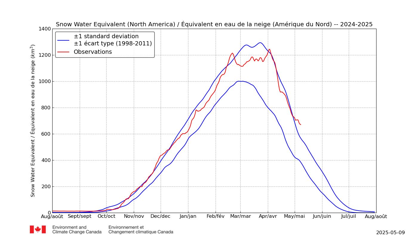
I think this is the earliest in the season we have broken the SWE scale (OK, probably tomorrow).
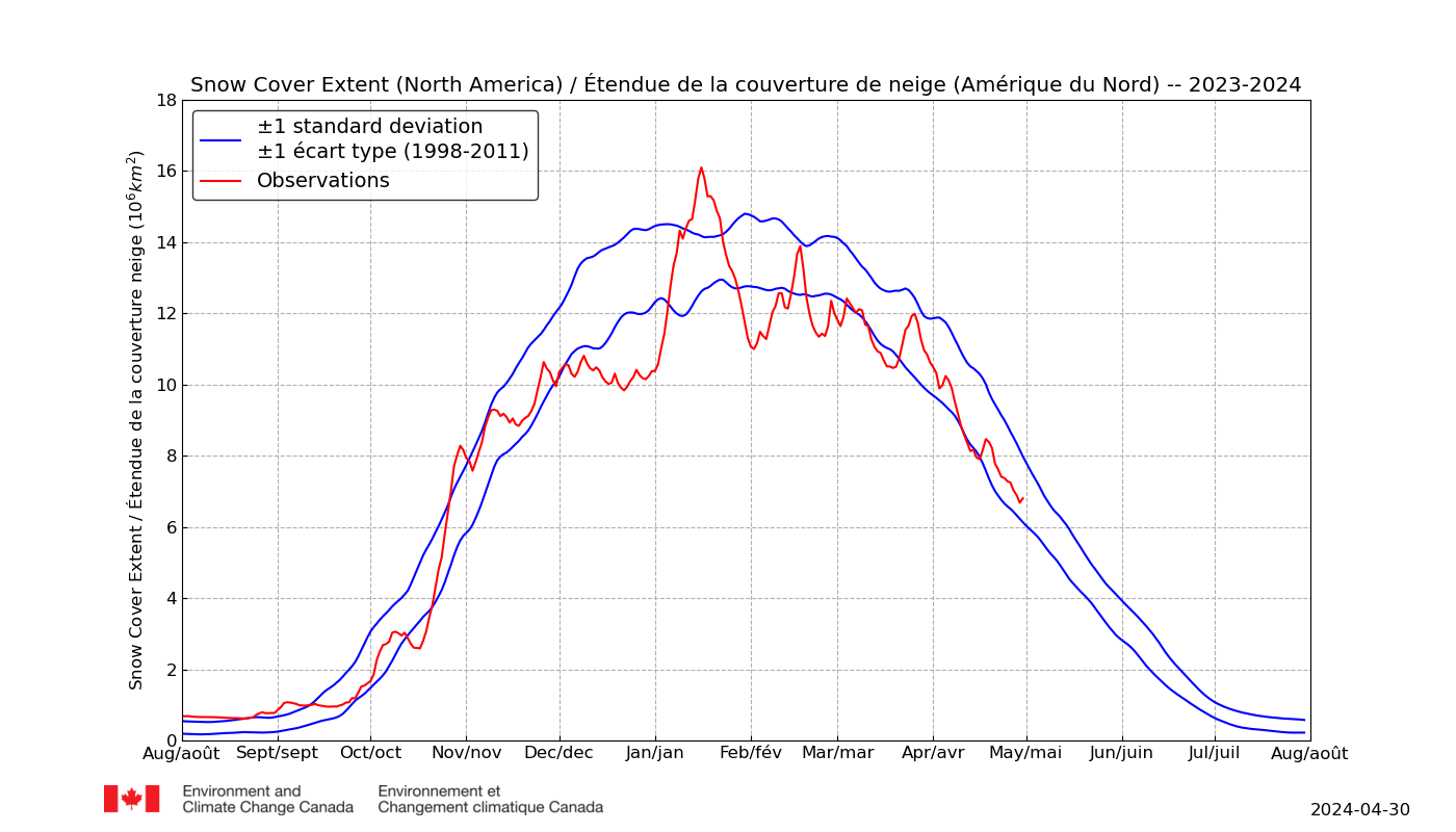
And extent is the highest I can recall seeing, ever, in North America.
PS: I know my predictions of a looming +SWE spiral are met with skepticism especially when it comes to scenarios of rapid glaciation but I think the situation in Texas illustrates how rapidly things can fail in the face of unexpected change.
It is interesting to note that the resilience in the face of increasingly warm summertime temperatures actually appears greater vs. wintertime cold. Heatwaves have progressed gradually in most regions, and also generally do not come with problems for power grids beyond actual capacity being an issue.
When Arctic blasts occur, supply is hindered and capacity is also stretched.
I think what we have just witnessed across the US is a prelude to worse events in the next 5-10 years. Oklahoma City recorded its lowest temperature since 1899, records were smashed everywhere, and it isn't the heart of winter -- it is almost late February, insolation is almost two months past minimum.
What happens when we see an Arctic blast with a magnitude worse than this persist for a week, or two weeks? And the roads are clogged, and it is snowing or icing, and the power is out? This does not necessitate glaciation btw, this could just be a two week period of weather similar to what we just saw, which is hardly unfeasible given the new records we are now setting across parts of the US.
It must also be noted that one of the regions which this airmass passed over /originated has been cold since last summer, and that is the NW Rockies in Canada, where summertime temps were 2-3C below 1980-2010 normals. Similar to the Himalayas, or the mountains of NE Eurasia, a 2-3C drop in summertime temperatures here allows snowpack to survive or accrete for most of the summer, in fact these temperatures were not that far above the threshold for re-glaciation as they are co-located with very high elevations.
With so much thick ice now extant in the Beaufort, I suspect that this region could play host to anomalies that are even worse this summer, although I have been very wrong in the past re: Quebec et al. However, Quebec is isolated from multi-year sea ice (Baffin and Hudson do not retain it / although MYI flows do drift into Baffin and smatterings may survive one year to the next in the channels of the CAA, but that is kind of further north).
The NW Rockies are directly downwind of the huge mass of ice now pushing onto Alaska and the Yukon's northern shore. This ice mass may be pushed off at some point in spring or summer, or it may not be, but in either case, I would think that as the FYI and snowcover melt in the lower latitudes, this region could become an anchor of cold and snow and relatively -500MB anomalies during NHEM spring + summertime, which could lead to continued Arctic Blasts into the lower 48, which will also lead to continued degradation of the ATL ice front, as these blasts will ultimately transport oceanic heat from the Gulf of Mexico and NW NATL into Greenland and the Barentz / Kara / CAB.
We are already seeing this pattern setting in across most modeling, with scorching anomalies centering over the CAB and peripheral ATL front on a persistent basis. The snowcover situation developing in North America is likely to further exacerbate the situation especially with insolation rapidly increasing. For now, the anomalies are generating heat close to freezing, and a lot of snow as well I would guess -- but we are only a few weeks or less from 0C+ temperatures resulting from these heat pulses across the Highest Arctic.
Finally, I am very curious to see what happens in Quebec as a result of the current / future pattern. While it has been very warm relative to normal, it has still been below freezing, and this relative warmth has simultaneously allowed much greater moisture / snowfall vs. normal February conditions across Quebec. As +500MB anomalies likely continue gaining prominence in the Highest Arctic as we head into spring, and the lowest latitudes melt out re: snowfall, -500MB anomalies are likely to concentrate in areas that retain +SWE, which probably includes Quebec. I could see the pattern shifting towards a very cold Canada in March, April, May, and possibly extending into June and July for the regions most prone to retaining snowpack.
This would severely blunt melting momentum for the Beaufort, Hudson, and CAA, while -- for reasons stated above -- contributing to melt momentum along the Atlantic oceanic periphery of the CAB.


