Time seems fit to re-vitalise this thread....
In the chase for extreme or ‘wacky’ weather I’m trying to notice ephemeral patterns that could later on be pointed to as being defining.
Could this be such a one?

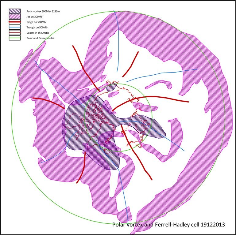
This is a combination of 300Mb jet, 500Mb ridges and troughs over the NH on 19 december. It looks like this pattern is having an effect on the sea ice, now that the ‘normal’ fall extent growth has almost been completed. It could well be from now on SIE/SIA and Volume will get in line with the ’07-’12 years.
I invite the fellow posters to discuss whether this pattern is anomalous. I haven’t studied this, I’m relying on my “gut-feel” having brooded over lots of this sort of graphs through the last three years.
There are at least three very deep trough incursions visible; representing Rossby-waves with large amplitude. The Polar Vortex has completely shifted away from the Pole, centering now on Foxe Bay and the Polar Circle (in green). It has a persistent trough-arm over S.Greenland, Iceland up to Scotland and another one, likely getting cut-off, into NW Siberia.
The main jetstream runs almost perfectly on the Tropic of Cancer in Eurasia, right into the W Pacific. It defines the tropics and the Hadley cell-boundary on 300Mb. North of it, there’s a vast half circle, spanning most of N. Eurasia and part of the Arctic Ocean, that has only small jet-features, even though the spikes of at least three Rossby-waves are running through it. While they create weather and certainly synoptic scale events of importance, it seems very well possible to suggest that the Polar and Ferrell cells have merged here.
The American side is quite different. Two Rossby-waves, that have a preferred hold or re-appearance over the same regions for months now, rotate under a wildly kinked Jet, drawn by or promoting the cold Vortex over NW Canada . This jet combines the extratropical and polar jet properties and lead to the violent weather contrasts in the USA-CONUS. The Ferrell cell is virtually non-existent here.
The propagation of the merging cells could get it’s particularities through the large-scale geomorphology of the NH. The Jet over Eurasia follows the west-east stretch of mountain ranges that reach right into mid-troposperic altitudes. The ‘kinky’ pattern on the other side is probably influenced through two massive Oceans and their anomalously warm waters and the bold north-south Rocky Mountain barrier.
Where will this go? The suggestion is that the Polar Vortex is contracting.
While it promotes some very cold weather in N America on 1000Mb, the temps through the troposphere as a whole over the NH are not cold. It ‘ll be interesting to check this with NCEP/NCAR through this winter.
This ‘not being very cold’ fits right into an analysis of the effects of smaller temp differences between the Tropics and the Poles. The relentlessly rising atmospheric levels of greenhouse gasses promote this.
The Rossby wave positions and amplitudes tend to resp. re-appear ‘stuck’ and get larger, not necessarily ‘more energetic’. I mean, they have been transferring massive amounts of energy over the past years, but while diminishing the Tropic-Pole temperature difference, their individual properties are not strikingly different from the climatologic trends. The enormous lengths of the ‘spaghetti’-line fronts between these features promote much more mixing of the energy at hand, that’s what makes the difference.
Taking this a bit further (and closing this post), the persistent low over the Arctic last summer fits into this pattern of merging cells. I would not be surprised to see this pattern continuing into a sort of ‘phase 23:40 hours’-global warming period, in which there would seem to be a certain pause in atmospheric boundary layer temp rise and Arctic sea ice melt-down.
