Support the Arctic Sea Ice Forum and Blog

Author Topic: 2014 El Nino?  (Read 962003 times)

wili

  • Young ice
  • Posts: 3342
    • View Profile
  • Liked: 602
  • Likes Given: 409
2014 El Nino?
« on: January 19, 2014, 09:05:59 PM »
We may be on the way to a major El Nino event:


http://origin.cpc.ncep.noaa.gov/products/people/wwang/cfsv2fcst/imagesInd3/nino34Mon.gif

Meanwhile, there is new info on the likelihood and consequences of more "super-El Nino's" as GW proceeds apace:

http://www.climatecentral.org/news/climate-change-could-make-super-el-ninos-more-likely-16976
[size=150]
Climate Change Could Double Likelihood of Super El Ninos[/size]


Quote
Under greenhouse warming the eastern equatorial Pacific warms faster than the surrounding regions . . . making it easier to have maximum SST (sea surface temperatures) in the eastern equatorial Pacific, and hence more occurrences of extreme El Nino events

(I know that this topic has come up on various threads, but it seemed of great enough potential consequence--globally and for the Arctic--to warrant it's own thread.)
« Last Edit: January 19, 2014, 09:19:29 PM by wili »
"A force de chercher de bonnes raisons, on en trouve; on les dit; et après on y tient, non pas tant parce qu'elles sont bonnes que pour ne pas se démentir." Choderlos de Laclos "You struggle to come up with some valid reasons, then cling to them, not because they're good, but just to not back down."

Neven

  • Administrator
  • First-year ice
  • Posts: 9433
    • View Profile
    • Arctic Sea Ice Blog
  • Liked: 1333
  • Likes Given: 617
Re: 2013 El Nino?
« Reply #1 on: January 19, 2014, 09:18:17 PM »
I've heard about that El Niño forecast, but Australia's BOM is of a different opinion:

Quote
Tropical Pacific remains ENSO-neutral

Issued on Tuesday 14 January 2014

The El Niño–Southern Oscillation (ENSO) remains in a neutral state, with all indicators well within neutral bounds. International climate models surveyed by the Bureau indicate this neutral ENSO state is likely to persist into the austral autumn. Some models suggest the central Pacific Ocean may warm during autumn and winter, while others remain near average. However, forecasts that span autumn have lower skill than forecasts at other times of year, and hence long-range model outlooks need to be used with more caution at this time of year. The Bureau will continue to monitor the ENSO state closely as forecasts become more reliable.

ENSO events (El Niño and La Niña) usually follow a typical life cycle. Events usually begin to develop during the austral autumn and winter months, mature during spring and summer, and rapidly weaken by the end of the following autumn.
The enemy is within
Don't confuse me with him

E. Smith

wili

  • Young ice
  • Posts: 3342
    • View Profile
  • Liked: 602
  • Likes Given: 409
Re: 2014 El Nino?
« Reply #2 on: January 19, 2014, 09:22:05 PM »
Thanks for including that, Neven. Note the question mark at the end of the (now emended--as usual, I'm living in the past) title.

I've seen different predictions even within NOAA (as noted recently on the blog). This most recent prediction (Jan. 19) showing a significantly stronger event than their prediction from just a few days ago (Jan. 13):


(Damn, the crucial part of that graph was cut off. Here's the link--thanks to ASLR, by the way.)
https://forum.arctic-sea-ice.net/index.php?action=dlattach;topic=41.0;attach=4498;image

How often do the Aussies update that prediction? I wonder if their next one will be more 'bearish.'

« Last Edit: January 19, 2014, 09:30:46 PM by wili »
"A force de chercher de bonnes raisons, on en trouve; on les dit; et après on y tient, non pas tant parce qu'elles sont bonnes que pour ne pas se démentir." Choderlos de Laclos "You struggle to come up with some valid reasons, then cling to them, not because they're good, but just to not back down."

werther

  • Grease ice
  • Posts: 747
    • View Profile
  • Liked: 31
  • Likes Given: 0
Re: 2014 El Nino?
« Reply #3 on: January 19, 2014, 10:29:06 PM »
Well, FWIW I’ve been comparing the initial position in January 2014 to that of 2009, about 5 months before the onset of the last main El Nino event:


The yellow area of positive anomaly is much larger now, especially in the centre, the north and southeast Pacific. I drew  a hatch just over the continuous swath; the warmer anomaly near Baja California is larger now, too.
By June ’09, the warm anomalies on the southern line Tonga-Easter Island had shifted into the first signs of El Nino along the equator.

I know looking back doesn’t tell much about what to expect in these days of expanding anomalies. But there are some similarities visible in and around the Pacific Basin between winter ’08-’09 and today. 
China, Eastern Australia and the Western US were experiencing drought then, too. Although present drought is really exceptional in California right now.

Chuck Yokota

  • New ice
  • Posts: 83
    • View Profile
  • Liked: 1
  • Likes Given: 0
Re: 2014 El Nino?
« Reply #4 on: January 19, 2014, 11:09:41 PM »
Are the NOAA and Australian forecasts really saying different things?  The Australian forecast a neutral ENSO state into austral autumn, and yes, the NOAA ensemble mean stays within the ENSO neutral state past April.  The Australian forecast says some models show warming of the central Pacific during austral autumn and winter, while others remain near average; and yes, the NOAA forcast has some ensemble members moving into El Nino range in June through October, and other members staying near neutral.  Where is there any contradiction?  The Australians are simply declining to place confidence that the ensemble mean is a good forecast tool that far out.
« Last Edit: January 19, 2014, 11:20:11 PM by Chuck Yokota »

Neven

  • Administrator
  • First-year ice
  • Posts: 9433
    • View Profile
    • Arctic Sea Ice Blog
  • Liked: 1333
  • Likes Given: 617
Re: 2014 El Nino?
« Reply #5 on: January 19, 2014, 11:20:04 PM »
Thanks, Chuck. I didn't read that attentively.

Wili, BOM updates its ENSO forecast every two weeks.
The enemy is within
Don't confuse me with him

E. Smith

Bruce Steele

  • Nilas ice
  • Posts: 2493
    • View Profile
  • Liked: 742
  • Likes Given: 40
Re: 2014 El Nino?
« Reply #6 on: January 20, 2014, 12:13:51 AM »
NOAA maintains a set of  buoy's that spans the Pacific along the equator. They are designed to monitor surface water dissolved Co2 (pCo2) . There are four years of data and it will be interesting to see how an El Nino affects pCo2.
 
 http://www.pmel.noaa.gov/co2/story/Open+Ocean+Moorings

A few of the latest CFSv2 model runs are in the +2 range and that would be something like the 82-83 or 97-98 events. The difference being the current PDO cold water phase,82-83 and 97-98 were in a warm water phase. 69 was a strong El Nino with associated rains but it occurred during a cold water PDO .
Either way from a Southern California perspective I say bring it on. Then there have been a couple
" careful what you wish for " warnings lately but there too I'd say bring it on.   

JimD

  • Nilas ice
  • Posts: 2272
    • View Profile
  • Liked: 6
  • Likes Given: 0
Re: 2014 El Nino?
« Reply #7 on: January 20, 2014, 12:40:30 AM »
Wili

From inside your 2nd link on climate change doubling the chance of super El Nino's Trenberth disagrees.  So this might be a bit unsettled yet.  I see that Bruce beat me to the negative PDO comment while I was typing.  I guess I have to speed up  :)  It will be interesting if we actually end up in an El Nino and continue the increasing frequency of El Nino's we have seen over the last 50 years or so.  Or whether we revert to the historical norm of La Nina dominance which often lasts decades.  I believe the projections are for increasing frequency but I am curious about that.  We will see. 

Quote
The core of Cai’s results, that more super El Ninos are likely, was disputed by Kevin Trenberth, a senior scientist at the National Corporation for Atmospheric Research.

He said some of the models used in the study overestimate the past number of El Nino events by a wide margin and do a poor job of representing them and their impacts.

“This seriously undermines the confidence that the models do an adequate job in ENSO (El Nino-Southern Oscillation) simulations and so why should we trust their future projections?” he said in an email.

Trenberth also said that some long-range climate models also fail to adequately simulate other natural climate patterns that influence El Nino let alone how they might also shift in a warming world
We do not err because truth is difficult to see. It is visible at a glance. We err because this is more comfortable. Alexander Solzhenitsyn

How is it conceivable that all our technological progress - our very civilization - is like the axe in the hand of the pathological criminal? Albert Einstein

AndrewP

  • Frazil ice
  • Posts: 129
    • View Profile
  • Liked: 0
  • Likes Given: 0
Re: 2014 El Nino?
« Reply #8 on: January 22, 2014, 07:34:20 AM »
Dynamic models have been predicting an El Nino 3-6 months in the future for the last year. We haven't even gone above 0.0 ONI. Given their performance for the last year, I remain skeptical of any developing El Nino. Right now I'd predict ENSO neutral through fall, although I would lean on the  slightly positive side of neutral in slight deference to the models.

wili

  • Young ice
  • Posts: 3342
    • View Profile
  • Liked: 602
  • Likes Given: 409
Re: 2014 El Nino?
« Reply #9 on: January 22, 2014, 11:33:41 AM »
Jim Hansen:
Quote
there is substantial likelihood of an El Niño beginning in 2014, and as a result a probable record global temperature in 2014 or 2015

http://www.columbia.edu/~jeh1/mailings/2014/20140121_Temperature2013.pdf

"A force de chercher de bonnes raisons, on en trouve; on les dit; et après on y tient, non pas tant parce qu'elles sont bonnes que pour ne pas se démentir." Choderlos de Laclos "You struggle to come up with some valid reasons, then cling to them, not because they're good, but just to not back down."

JimD

  • Nilas ice
  • Posts: 2272
    • View Profile
  • Liked: 6
  • Likes Given: 0
Re: 2014 El Nino?
« Reply #10 on: January 22, 2014, 04:42:14 PM »
 Wili,

I think it is fair to say that the Hansen link you provided does not cover any new territory, but is a review of what is known with the goal of providing insight into what has been happening for those being confused by the denier camp.  A worthy goal of course.

It seems pretty certain that this little struggle which was exacerbated by the last decades slowing of the rate of increase will not go away until we actually do have that new record year some are indicating will happen with the next El Nino.  But folks should be careful about pushing the probability of one occurring this year until there is a more stronger forecast I think.  The blowback will be a pain to deal with if it does not happen.

We should keep in mind that Hansen made a prediction like this once before and predicted that 2012 would be the record year because of a coming El Nino (that did not happen).

 
We do not err because truth is difficult to see. It is visible at a glance. We err because this is more comfortable. Alexander Solzhenitsyn

How is it conceivable that all our technological progress - our very civilization - is like the axe in the hand of the pathological criminal? Albert Einstein

deep octopus

  • Grease ice
  • Posts: 559
    • View Profile
  • Liked: 6
  • Likes Given: 17
Re: 2014 El Nino?
« Reply #11 on: January 22, 2014, 05:09:42 PM »
Jim, I believe the expectation was for an El Niño to make 2013 the record year, not 2012; and 2012 was a La Niña year. That El Niño was never expected to amount to much, anyway. I recall that it was expected to be rather weak, and it never materialized as there was simply too much cool water punching through during autumn 2012 to make it happen. Still, 2013 was quite warm, so that does count for what it was.

I'll agree with you otherwise. Odds of El Niño seem higher this year, if only because models are convinced of one so early in the year, and we're entering a second year of Pacific neutrality, which is usually followed by El Niño. A dud this year would be demoralizing for those who have been waiting for an unmistakable record year to occur, but physics will behave as it well. But we really won't get a firm grasp until, say, May. Though El Niño can develop very furiously and swiftly, as happened in 1997. One day in April, it was La Niña; within days, it was El Niño.


If things start really heating up this spring, I'll be in an excited state for the rest of the year.

ritter

  • Grease ice
  • Posts: 573
    • View Profile
  • Liked: 24
  • Likes Given: 0
Re: 2014 El Nino?
« Reply #12 on: January 22, 2014, 05:29:06 PM »
I'd really rather a record come in a non el nino year so deniers can't blame the record on el nino.  ;)

Rubikscube

  • Frazil ice
  • Posts: 254
    • View Profile
  • Liked: 5
  • Likes Given: 4
Re: 2014 El Nino?
« Reply #13 on: January 22, 2014, 06:25:34 PM »
We've now got 43 months without a proper El Niño and no matter what happens, we know it will be a couple more months like this, therefore it is extremly interesting to note that there have been no recorded periods of more than 50 months without El Niño since 1950
http://www.cpc.ncep.noaa.gov/products/analysis_monitoring/ensostuff/ensoyears.shtml
note that in periods of 50 months between 1959-1963 and 1978-1982 there were neither El Niños or La niñas. I therefore feel very confident that we either get a strong El Niño or a "double niño".

The reason why there have been caution in predictions made are because moddels traditionally struggle with the so called "spring barrier", in the period between January and April there are very few physical signs of developing Niños and as a result moddels often differ greatly, change their minds frequently and generally struggle to see what will happen, those interpreting the data consequently restrain themselves to saying there is a 50/50 chance although current data suggests otherwise. This uncertainty can clearly be seen on the current CFS map, where oct 2014 predictions span from -0,2 to more than 3, though, as I said, I still feel confortable of an El niño in 2014. My personal numbers for the 2014/15 winter based purely on speculation around statistical data are as follows; 85% chance of El Niño, 40% of a "2010-or-stronger niño", 10% of a "1998-or-stronger niño" and 5% for La niña.

JimD

  • Nilas ice
  • Posts: 2272
    • View Profile
  • Liked: 6
  • Likes Given: 0
Re: 2014 El Nino?
« Reply #14 on: January 22, 2014, 09:12:01 PM »
DO & Rubic

I must say I agree with ritter, but the main reason I shy away from excitement (if that is the right word) about the possibility is not just that Hansen's earlier call went wrong (that I misremembered the date does not change that) and that hurts the narrative.

I just finished reading a book that had extensive information on the paleo-record of El Nino's (or rather of ENSO either way) and the frequency of El Nino's since 1950 mentioned by Rubic above is anonymous in the record.  The switching back and forth from El Nino's to La Nina's we have seen the last 50 years is not normal when the record is fully looked at and this is mentioned in many papers.  Now this is probably related to AGW and it might, but just might, mean that this volatility is here to stay.  But it also might not.  In the past 1000 years the dominant part of the cycle is La Nina's and some appear to have lasted for over 100 years.  But there have also been periods where it switched more frequently.  Thus my sympathy with ritter's comment.  Even if we do not get an El Nino we are not far from a neutral or La Nina year which would break the record anyway.  And that would have a lot of narrative impact.  I think.  I guess I am just being cautious in my enthusiasm.
We do not err because truth is difficult to see. It is visible at a glance. We err because this is more comfortable. Alexander Solzhenitsyn

How is it conceivable that all our technological progress - our very civilization - is like the axe in the hand of the pathological criminal? Albert Einstein

CraigsIsland

  • Frazil ice
  • Posts: 206
    • View Profile
  • Liked: 4
  • Likes Given: 25
Re: 2014 El Nino?
« Reply #15 on: January 22, 2014, 09:25:45 PM »
Deep Octopus- thanks for the info. I didn't realize a El Niño state could be brought about in a matter of days. Definitely good news as I had assumed it took months of slow buildup. Fingers crossed.

deep octopus

  • Grease ice
  • Posts: 559
    • View Profile
  • Liked: 6
  • Likes Given: 17
Re: 2014 El Nino?
« Reply #16 on: January 22, 2014, 10:31:33 PM »
Craig, not to confuse, but what I meant was not to suggest that ENSO can change (and mature) from one state to the next in a matter of days--only that, in a case like 1997, the sea surface temperatures had been in a La Niña state in the early months of the year, while below the surface, the ocean had been warming up for several weeks. By the end of the month, the cool waters had rapidly subsided, and the warm waters from an eastward propagating Kelvin wave began to dominate. It's clear that in April 1997, that was the point at which the trade winds finally "broke down" and the positive feedback towards El Niño began relentlessly.


The actual El Niño event did take several months to fully build (beginning April 1997 and peaking in late November 1997): 
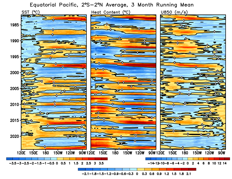
http://www.cpc.ncep.noaa.gov/data/indices/wksst8110.for

What is impressive to me was how early things began heating in the eastern Pacific, in late April no less. In the most recent 2009-2010 El Niño, the vital signs of the event were barely present until June 2009. Weak El Niños like 1995 and 2007 had little going on until about September of their respective previous years. I suppose this meant that the earlier maturity of 1997 helped prolong the monster's ability to amplify to the size it did, finally releasing heat to the atmosphere as the seasons changed over to the northern winter of 1997-1998. And I wonder aloud (perhaps pointlessly at this stage) if we may see an early development this year. Who knows.

But Jim, I understand what you're saying, and I suppose my "excitement" is a bit vain, though it's purely from an academic standpoint. It's said that ENSO, as an unforced internal variability, should balance over the long term, and as it's internal, it really has no bearing on the overall trend, and its effectiveness in global warming is how it distributes heat from the ocean to the atmosphere. Of course, when discussing time scales (particularly human ones), one's idea of "long term" differs. If La Niña dominates for 100 years, do we still have similar temperature projections by 2100 compared to if El Niño dominates? Your mileage may vary. I am in the dark there. We are still grasping with just how unique the phenomenon of El Niño actually is against the paleo record. Some of its history (dominance versus absence) is posited to have had to do with orbital forcing and deglaciation, at least in terms of the Holocene. The idea of what is "normal" is slippery to grasp, indeed, especially in climate history when we deal with unimaginably significant variables: atmospheric conditions, plate tectonics and thermohaline circulation, insolation, volcanoes, etc. So many circumstances that scientists translate to our present time with care.

Whether we are entering a period in which one form of ENSO or another is absent or dominant, or just more of the same, the recent literature remains confusing to say the least. On one hand, some have saying the Walker Circulation will strengthen from AGW and that this fuels La Niña; others say a weaker Walker Circulation is still possible; others suggest that a warming western Pacific will result in more frequently intense El Niños. I honestly have no idea, and I agree in a way that no El Niño with a record temperature would be more interesting than having an El Niño with a record. It's certainly more unique and harder to explain than simply "Oh, 2015 was an El Niño, so carry on."

I saw in another thread you were asking about paleo records for El Niño. I'm reading through some to see if they address your question and will try to help you soon as I find something useful. You might seek out some of Mark Cane's work. He has done much on the subject, including its history.
« Last Edit: January 22, 2014, 10:38:39 PM by deep octopus »

AndrewP

  • Frazil ice
  • Posts: 129
    • View Profile
  • Liked: 0
  • Likes Given: 0
Re: 2014 El Nino?
« Reply #17 on: January 22, 2014, 10:51:44 PM »
Jim Hansen:
Quote
there is substantial likelihood of an El Niño beginning in 2014, and as a result a probable record global temperature in 2014 or 2015

http://www.columbia.edu/~jeh1/mailings/2014/20140121_Temperature2013.pdf

Hansen has 'guaranteed' El Ninos that have never materialized in the past so I would not put too much stock in this.

The subsurface has been very warm for a year and a half now and no El Nino has developed. The trade winds have been relentless. This is common in -PDOs.

Right now the SON trimonthly I'd go with 15% La Nina 55% neutral and 35% El nino (15% of moderate or higher).

wili

  • Young ice
  • Posts: 3342
    • View Profile
  • Liked: 602
  • Likes Given: 409
Re: 2014 El Nino?
« Reply #18 on: January 23, 2014, 10:01:28 PM »
"Hansen has 'guaranteed' El Ninos..."

Even so, you'll have to forgive me for giving a bit more weight to the judgment of the (now former) top climatologist at NASA than to that of some anonymous dude on a blog (no offense intended--I'm the same kind of anonymous dude).
"A force de chercher de bonnes raisons, on en trouve; on les dit; et après on y tient, non pas tant parce qu'elles sont bonnes que pour ne pas se démentir." Choderlos de Laclos "You struggle to come up with some valid reasons, then cling to them, not because they're good, but just to not back down."

AndrewP

  • Frazil ice
  • Posts: 129
    • View Profile
  • Liked: 0
  • Likes Given: 0
Re: 2014 El Nino?
« Reply #19 on: January 24, 2014, 06:35:18 AM »
I'm not saying take my word. Take that of the CPC or Australian BOM. They have a proven track record with ENSO.

Hansen has very little expertise, if any, in the prediction of ENSO. Yes he's a 'climatologist' but there are many specializations within that. Look at his background.

deep octopus

  • Grease ice
  • Posts: 559
    • View Profile
  • Liked: 6
  • Likes Given: 17
Re: 2014 El Nino?
« Reply #20 on: January 27, 2014, 06:44:43 PM »
By the way, I have come across some disturbing news regarding the decline of buoys out in the tropical Pacific that track the development of El Niño.

Quote
El Niño tracking system in Pacific Ocean faces collapse

The Abbott government says it has no plans to help fund a Pacific Ocean system of buoys monitoring extreme weather patterns that is now facing collapse.

Leading ocean experts, including senior Australian scientists, will gather in California on Tuesday to discuss the "abrupt decline" over the past 18 months of data from an array of deep-water buoys.

Known as the Tropical Atmosphere Ocean Project, or TAO, the array of devices has been funded for about 30 years mostly by the US and Japan.

As revealed by Fairfax Media, vandalism by fishing fleets and cuts in spending on regular maintenance visits have led to a 40 per cent reduction in the flow of information from the buoys. The slide is continuing.

 "The implosion of the TAO is a real tragedy for the oceanographic and climate community," said Mike McPhaden, a principal scientist with the US National Oceanic and Atmospheric Administration and former manager of the array.

The TAO, set up after a huge El Nino weather system surprised scientists in 1982-83, delivers critical real-time observation of atmospheric conditions and those of the sea down to 500 metres below the buoys. El Ninos, and their opposite pattern, La Ninas, typically shift rain east or west over the Pacific, often bringing drought or heavy rains to many parts of the world, including Australia.

Read more: http://www.smh.com.au/national/el-nino-tracking-system-in-pacific-ocean-faces-collapse-20140127-31iy3.html#ixzz2rcXqVeLd

and

Quote
El Niño monitoring system in failure mode

Nearly half of the moored buoys in the Tropical Atmosphere Ocean (TAO) array have failed in the last two years, crippling an early-warning system for the warming and cooling events in the eastern equatorial Pacific, known respectively as El Niño and La Niña. Scientists are now collecting data from just 40% of the array.

...

The array's troubles began in 2012, when budget cuts pushed NOAA to retire a ship dedicated to performing the annual servicing that keeps the TAO buoys in working order. According to McPhaden, NOAA's annual budget for the project stood at about US$10‒$12 million before 2012 — a figure that included around $6 million to cover the dedicated ship. In fiscal year 2013, the agency spent $2‒$3 million to charter boats for maintenance runs, but McPhaden says that these operations have not been enough to keep the system going. Meanwhile, although JAMSTEC has thus far kept its portion of the array up and running, it too is under budgetary pressure.

http://www.nature.com/news/el-ni%C3%B1o-monitoring-system-in-failure-mode-1.14582

I can't help but think that the climate change deniers in the governments of the United States and Australia are failing us all by continuously cutting funding to research that would allow continued maintenance and improvements of the buoys. It's also a threat to people's well-being to limit this kind of information. El Niño and La Niña can be vicious to agriculture and have knowingly led to famines, particularly in the 19th and early 20th centuries when they arrived without warning. And it's costly. Talk about penny-wise, pound-foolish.

wili

  • Young ice
  • Posts: 3342
    • View Profile
  • Liked: 602
  • Likes Given: 409
Re: 2014 El Nino?
« Reply #21 on: January 27, 2014, 07:32:36 PM »
Thanks, DO. Yes, I've seen those reports. A whole new level of depressing! Not only is an ever-more intense shit storm definitely coming our way, we will be flying into it ever more blindly.

For the meantime, though: El Nino predictions summer are neutral, but for fall they continue to look fairly positive:

http://www.cpc.ncep.noaa.gov/products/analysis_monitoring/lanina/enso_evolution-status-fcsts-web.pdf (esp. pp. 26-27)

The Australian BOM has not updated yet, but it's always good to append their caveat:
"long-range model outlooks need to be used with more caution at this time of year"


« Last Edit: January 27, 2014, 07:38:12 PM by wili »
"A force de chercher de bonnes raisons, on en trouve; on les dit; et après on y tient, non pas tant parce qu'elles sont bonnes que pour ne pas se démentir." Choderlos de Laclos "You struggle to come up with some valid reasons, then cling to them, not because they're good, but just to not back down."

wili

  • Young ice
  • Posts: 3342
    • View Profile
  • Liked: 602
  • Likes Given: 409
Re: 2014 El Nino?
« Reply #22 on: January 29, 2014, 07:25:24 PM »
BOM now moving toward El Nino predictions for later this year:

http://www.bom.gov.au/climate/enso/

Quote
...tropical Pacific Ocean will warm through the southern autumn and winter. Some, but not all, models predict this warming may approach El Niño thresholds by early winter.
"A force de chercher de bonnes raisons, on en trouve; on les dit; et après on y tient, non pas tant parce qu'elles sont bonnes que pour ne pas se démentir." Choderlos de Laclos "You struggle to come up with some valid reasons, then cling to them, not because they're good, but just to not back down."

wili

  • Young ice
  • Posts: 3342
    • View Profile
  • Liked: 602
  • Likes Given: 409
Re: 2014 El Nino?
« Reply #23 on: February 03, 2014, 04:19:08 PM »
Gavin Schmidt is also anticipating an El Nino year. " An El Nino trend is likely to develop this year, Gavin Schmidt, deputy director of NASA’s Goddard Institute for Space Studies in New York, said this month."

http://www.bloomberg.com/news/2014-01-28/el-nino-may-develop-as-most-models-predict-pacific-ocean-warming.html
"A force de chercher de bonnes raisons, on en trouve; on les dit; et après on y tient, non pas tant parce qu'elles sont bonnes que pour ne pas se démentir." Choderlos de Laclos "You struggle to come up with some valid reasons, then cling to them, not because they're good, but just to not back down."

Gray-Wolf

  • Grease ice
  • Posts: 948
    • View Profile
  • Liked: 131
  • Likes Given: 458
Re: 2014 El Nino?
« Reply #24 on: February 03, 2014, 07:40:55 PM »
http://www.columbia.edu/~jeh1/mailings/2014/20140121_Temperature2013.pdf

Final section concerns the Nino and potential 'Super' but the whole paper is worth a gander I.M.H.O.
KOYAANISQATSI

ko.yaa.nis.katsi (from the Hopi language), n. 1. crazy life. 2. life in turmoil. 3. life disintegrating. 4. life out of balance. 5. a state of life that calls for another way of living.
 
VIRESCIT VULNERE VIRTUS

wili

  • Young ice
  • Posts: 3342
    • View Profile
  • Liked: 602
  • Likes Given: 409
Re: 2014 El Nino?
« Reply #25 on: February 04, 2014, 07:17:24 PM »
Thanks for that GW.

NOAA's latest (Feb. 3) continues to show El Nino forming in May-June and strengthening through August-September.

http://www.cpc.ncep.noaa.gov/products/analysis_monitoring/lanina/enso_evolution-status-fcsts-web.pdf

(p. 27)
"A force de chercher de bonnes raisons, on en trouve; on les dit; et après on y tient, non pas tant parce qu'elles sont bonnes que pour ne pas se démentir." Choderlos de Laclos "You struggle to come up with some valid reasons, then cling to them, not because they're good, but just to not back down."

deep octopus

  • Grease ice
  • Posts: 559
    • View Profile
  • Liked: 6
  • Likes Given: 17
Re: 2014 El Nino?
« Reply #26 on: February 04, 2014, 07:57:13 PM »
Page 16 of NOAA's weekly ENSO report is most interesting to me. Present cooling in the central Pacific can be attributed to a cold Kelvin wave phase that will reach the eastern Pacific by March (this is supported by Nino 1+2 models as well.)


The action to watch right now will be that warm Kelvin wave pushing off the western Pacific (around 140 E to 175 W), which will probably reach the central/eastern Pacific by mid or late April. This would be about the point when the spring barrier is being lifted and we'll have more clarity on the direction of things. Page 17 also shows this same Kelvin wave and the huge westerlies its producing. These were also the same westerlies that BOM was referring to in its last update.

Quote
While most ENSO indicators are neutral, strong westerly winds currently over the far western tropical Pacific may lead to some warming of the tropical Pacific Ocean in the coming weeks.

Any slackening of trade winds by the end of April or early May as a result of warm Kelvin waves pushing east would be very good tinder for an El Niño.

werther

  • Grease ice
  • Posts: 747
    • View Profile
  • Liked: 31
  • Likes Given: 0
Re: 2014 El Nino?
« Reply #27 on: February 04, 2014, 11:42:21 PM »
You are right, Deep Octopus!
These anomalous westerlies near Fiji and Samoa caught my attention too. I don't have much knowledge to suggest this is really important. But your analysis seems convincing that 'something' is brewing.

crandles

  • Young ice
  • Posts: 3379
    • View Profile
  • Liked: 239
  • Likes Given: 81
Re: 2014 El Nino?
« Reply #28 on: February 06, 2014, 04:45:47 PM »
9th Jan
Quote
ENSO-neutral is expected to continue into the Northern Hemisphere summer 2014.

has changed to 6th Feb version:

Quote
ENSO-neutral is expected to continue through the Northern Hemisphere spring 2014.

Maybe reflects more chance of early summer transition to el nino.


has a few models staying below 0.5. All bar just 1 model moves to and stays positive.

Gray-Wolf

  • Grease ice
  • Posts: 948
    • View Profile
  • Liked: 131
  • Likes Given: 458
Re: 2014 El Nino?
« Reply #29 on: February 09, 2014, 01:00:20 PM »
http://i.imgur.com/VB24wvf.gif

Looking more like a super as the weeks pass by?
KOYAANISQATSI

ko.yaa.nis.katsi (from the Hopi language), n. 1. crazy life. 2. life in turmoil. 3. life disintegrating. 4. life out of balance. 5. a state of life that calls for another way of living.
 
VIRESCIT VULNERE VIRTUS

JimD

  • Nilas ice
  • Posts: 2272
    • View Profile
  • Liked: 6
  • Likes Given: 0
Re: 2014 El Nino?
« Reply #30 on: February 10, 2014, 06:02:45 PM »
Grey-Wolf

Did you note that crandles chart post dates yours?  Thus the trends of the models is less rather than more positive on the indice., though the two charts are only 2 days apart. 

Everyone seems to be getting very excited, but we are a long way out still.  Anything can still happen.
We do not err because truth is difficult to see. It is visible at a glance. We err because this is more comfortable. Alexander Solzhenitsyn

How is it conceivable that all our technological progress - our very civilization - is like the axe in the hand of the pathological criminal? Albert Einstein

deep octopus

  • Grease ice
  • Posts: 559
    • View Profile
  • Liked: 6
  • Likes Given: 17
Re: 2014 El Nino?
« Reply #31 on: February 10, 2014, 06:49:03 PM »
I maintain that the most interesting point this year will begin around May. No doubt that, in February, it's quite early by and large. That's not to say that nothing that happens now doesn't matter. One can go back in time to read NOAA's notes back in 1997, when signs of El Niño were witnessed in late February and early March of that year.

http://www.ospo.noaa.gov/Products/ocean/sst/anomaly/1997.html

That's why I'm still watching these occurrences. But things do reach critical mass the further into the year we go. As far as super El Niño, we'll have to see if we even get an El Niño at all first. We would probably have to see Niño 3.4 explode to 2 degrees C by next fall to get anything super. I don't see it yet, even in the models as far out as October. It could happen though. We'll see. The fairest points I can make so far are that: currently, the central/eastern Pacific has below average temperatures, likely because of the upwelling Kelvin wave in the east. So ENSO is on the cool side of neutral. Going foward, when it matters (as in, weeks and months ahead), we see a lot of potential.

Sort of like spectating Arctic sea ice, I'm curious from an educational standpoint just how things will unfold this year, since there is a lot of fuzz about this possibly happening. For the purposes of spectating, there are some observable events taking place that are consistent with the future development of El Niño. The two factors I'm watching are trade winds and subsurface ocean temperatures. Since a week ago, the trade winds along the equator have been broadly weaker. All along the equatorial Pacific, trades have been more westerly at the 850 hPa level. They are now moving in a more orchestrated ensemble, as though a single entity pushing winds more to the east. Will it keep up?


Some very warm water (around 4-5 degrees C above average) can be associated with the new warm Kelvin wave that's now progressing eastward. So, there is a lot of fuel lurking beneath.


wili

  • Young ice
  • Posts: 3342
    • View Profile
  • Liked: 602
  • Likes Given: 409
Re: 2014 El Nino?
« Reply #32 on: February 11, 2014, 01:32:32 AM »
Now this:
http://www.climatecentral.org/news/study-sounds-el-nino-alarm-for-2014-17052

Study Sounds ‘El Niño Alarm’ For Late This Year


Quote
While the forecast models in use today tend to rely on observations of the ocean conditions and trade winds that generally blow from east to west across the tropical Pacific, the new method relies on an index that compares surface air temperatures in the area where El Niño events typically occur with temperatures across the rest of the Pacific.

The researchers found that a strong link between air temperatures across the Pacific and air temperatures in region where El Niño forms appears about one calendar year before an actual El Niño event. Taking advantage of this observation, the scientists devised a forecasting index based on the strength of the links between temperatures in and around the El Niño region. This index, the study said, points to a high likelihood of an upcoming El Niño late in 2014.
"A force de chercher de bonnes raisons, on en trouve; on les dit; et après on y tient, non pas tant parce qu'elles sont bonnes que pour ne pas se démentir." Choderlos de Laclos "You struggle to come up with some valid reasons, then cling to them, not because they're good, but just to not back down."

Pmt111500

  • Guest
Re: 2014 El Nino?
« Reply #33 on: February 11, 2014, 12:01:53 PM »
Quote
The researchers found that a strong link between air temperatures across the Pacific and air temperatures in region where El Niño forms appears about one calendar year before an actual El Niño event. Taking advantage of this observation, the scientists devised a forecasting index based on the strength of the links between temperatures in and around the El Niño region. This index, the study said, points to a high likelihood of an upcoming El Niño late in 2014.

13/15 (16) succesful predictions is pretty well (fig 2. in the article)(13% error in hits, 1 in 8 or 9), also notable that they missed only 4/18 nino episodes (22%), so there could also be another mechanism for developing el nino. I'm in a pretty firm belief their network of climate (weather) used in calculating the forecast could be smaller but yes it's good to be thourough. Very interesting paper.

JimD

  • Nilas ice
  • Posts: 2272
    • View Profile
  • Liked: 6
  • Likes Given: 0
Re: 2014 El Nino?
« Reply #34 on: February 11, 2014, 08:26:11 PM »
I guess this fits here.

Recent intensification of wind-driven circulation in the Pacific and the ongoing warming hiatus

Abstract
Quote
Despite ongoing increases in atmospheric greenhouse gases, the Earth’s global average surface air temperature has remained more or less steady since 2001. A variety of mechanisms have been proposed to account for this slowdown in surface warming. A key component of the global hiatus that has been identified is cool eastern Pacific sea surface temperature, but it is unclear how the ocean has remained relatively cool there in spite of ongoing increases in radiative forcing. Here we show that a pronounced strengthening in Pacific trade winds over the past two decades—unprecedented in observations/reanalysis data and not captured by climate models—is sufficient to account for the cooling of the tropical Pacific and a substantial slowdown in surface warming through increased subsurface ocean heat uptake. The extra uptake has come about through increased subduction in the Pacific shallow overturning cells, enhancing heat convergence in the equatorial thermocline. At the same time, the accelerated trade winds have increased equatorial upwelling in the central and eastern Pacific, lowering sea surface temperature there, which drives further cooling in other regions. The net effect of these anomalous winds is a cooling in the 2012 global average surface air temperature of 0.1–0.2 °C, which can account for much of the hiatus in surface warming observed since 2001. This hiatus could persist for much of the present decade if the trade wind trends continue, however rapid warming is expected to resume once the anomalous wind trends abate.

http://www.nature.com/nclimate/journal/vaop/ncurrent/full/nclimate2106.html
We do not err because truth is difficult to see. It is visible at a glance. We err because this is more comfortable. Alexander Solzhenitsyn

How is it conceivable that all our technological progress - our very civilization - is like the axe in the hand of the pathological criminal? Albert Einstein

Shared Humanity

  • Guest
Re: 2014 El Nino?
« Reply #35 on: February 12, 2014, 01:27:53 AM »
I guess this fits here.

Recent intensification of wind-driven circulation in the Pacific and the ongoing warming hiatus

Abstract
Quote
Despite ongoing increases in atmospheric greenhouse gases, the Earth’s global average surface air temperature has remained more or less steady since 2001. A variety of mechanisms have been proposed to account for this slowdown in surface warming. A key component of the global hiatus that has been identified is cool eastern Pacific sea surface temperature, but it is unclear how the ocean has remained relatively cool there in spite of ongoing increases in radiative forcing. Here we show that a pronounced strengthening in Pacific trade winds over the past two decades—unprecedented in observations/reanalysis data and not captured by climate models—is sufficient to account for the cooling of the tropical Pacific and a substantial slowdown in surface warming through increased subsurface ocean heat uptake. The extra uptake has come about through increased subduction in the Pacific shallow overturning cells, enhancing heat convergence in the equatorial thermocline. At the same time, the accelerated trade winds have increased equatorial upwelling in the central and eastern Pacific, lowering sea surface temperature there, which drives further cooling in other regions. The net effect of these anomalous winds is a cooling in the 2012 global average surface air temperature of 0.1–0.2 °C, which can account for much of the hiatus in surface warming observed since 2001. This hiatus could persist for much of the present decade if the trade wind trends continue, however rapid warming is expected to resume once the anomalous wind trends abate.

http://www.nature.com/nclimate/journal/vaop/ncurrent/full/nclimate2106.html

They mention the changes in the trade winds but give no explanation. Could these strengthening trade winds be a result of AGW and, if so, could the increased equatorial upwelling and cooling of the central and eastern Pacific  make it more difficult for an El Nino to form?

wili

  • Young ice
  • Posts: 3342
    • View Profile
  • Liked: 602
  • Likes Given: 409
Re: 2014 El Nino?
« Reply #36 on: February 12, 2014, 02:12:08 AM »
Those are the questions I posed at SkS's post on this article,  and other agreed that those were the questions that they had. But I haven't gotten any official response yet. One article mentioned that warming of the Indian Ocean may contribute to strengthening these winds, but there didn't seem to be much conviction behind that theory. It would be nice to know what drives them, so we might know how and when they may stop.

"A force de chercher de bonnes raisons, on en trouve; on les dit; et après on y tient, non pas tant parce qu'elles sont bonnes que pour ne pas se démentir." Choderlos de Laclos "You struggle to come up with some valid reasons, then cling to them, not because they're good, but just to not back down."

AndrewP

  • Frazil ice
  • Posts: 129
    • View Profile
  • Liked: 0
  • Likes Given: 0
Re: 2014 El Nino?
« Reply #37 on: February 13, 2014, 03:44:53 PM »
As I said before the CFSv2 pointed to an El Nino most of last year (all members positive often) and we stayed negative most of the year. It's not so reliable.

The -PDO may have something to do with it.

BornFromTheVoid

  • Nilas ice
  • Posts: 1339
    • View Profile
  • Liked: 679
  • Likes Given: 299
Re: 2014 El Nino?
« Reply #38 on: February 15, 2014, 12:30:39 PM »
There's been a big warm up in the Nino 4 and 3.4 region over the past few days.


Normal variation or the start of a change? Something to keep an eye on over the next while methinks.
I recently joined the twitter thing, where I post more analysis, pics and animations: @Icy_Samuel

Gray-Wolf

  • Grease ice
  • Posts: 948
    • View Profile
  • Liked: 131
  • Likes Given: 458
Re: 2014 El Nino?
« Reply #39 on: February 15, 2014, 01:20:09 PM »
Hi BFTV!

Maybe this is a response to the 'Pineapple express' of last weekend? The High over the N.Pacific gave way ( a bit) to allow the rain in and so the winds on it's souther flank died light. Those winds must have been augmenting the trades which were pinning the warm bulge back?

Maybe we should see the extension of warm fade as the winds build back up and pin the waters back to the east again?

If we see this then I suggest we keep mindful of the H.P. 'altering' as the ITCZ moves north this spring?

98's Nino took 3 weeks to go from neutral to full blown Nino so it wouldn't take a long break in the trades to have the 'dam' break.
KOYAANISQATSI

ko.yaa.nis.katsi (from the Hopi language), n. 1. crazy life. 2. life in turmoil. 3. life disintegrating. 4. life out of balance. 5. a state of life that calls for another way of living.
 
VIRESCIT VULNERE VIRTUS

BornFromTheVoid

  • Nilas ice
  • Posts: 1339
    • View Profile
  • Liked: 679
  • Likes Given: 299
Re: 2014 El Nino?
« Reply #40 on: February 16, 2014, 12:23:11 PM »
The PDO for January 2014 is +0.3, making it the most positive since May 2010.
I wonder if this will weaken the dampening effect, allowing a brief El Nino, like during the last +ve PDO spell between Autumn 2009 and Spring 2010?

I recently joined the twitter thing, where I post more analysis, pics and animations: @Icy_Samuel

wili

  • Young ice
  • Posts: 3342
    • View Profile
  • Liked: 602
  • Likes Given: 409
Re: 2014 El Nino?
« Reply #41 on: February 17, 2014, 06:21:44 AM »
Sorry to sound like a stuck record, but SkS picked up on CC's El Nino story, so another group of thoughtful scientists and journalists that thought it was worth highlighting??
http://www.skepticalscience.com/2014-SkS-Weekly-News-Roundup_7.html

It will be interesting to see what tomorrow's NOAA report shows.
"A force de chercher de bonnes raisons, on en trouve; on les dit; et après on y tient, non pas tant parce qu'elles sont bonnes que pour ne pas se démentir." Choderlos de Laclos "You struggle to come up with some valid reasons, then cling to them, not because they're good, but just to not back down."

wili

  • Young ice
  • Posts: 3342
    • View Profile
  • Liked: 602
  • Likes Given: 409
Re: 2014 El Nino?
« Reply #42 on: February 18, 2014, 05:58:19 PM »
And here it is:

Latest NOAA forecast is out, and it says...

Quote
models predict either ENSO-neutral or El Niño (greater or equal to
+0.5ºC) during the Northern Hemisphere summer 2014
(p. 26)

Quote
...El Niño starting in May-July 2014
(p. 27)

http://www.cpc.ncep.noaa.gov/products/analysis_monitoring/lanina/enso_evolution-status-fcsts-web.pdf

Probably too late to send much rain to the parched West this year, though. What might the effects be elsewhere, especially if this thing grows into a major one?
"A force de chercher de bonnes raisons, on en trouve; on les dit; et après on y tient, non pas tant parce qu'elles sont bonnes que pour ne pas se démentir." Choderlos de Laclos "You struggle to come up with some valid reasons, then cling to them, not because they're good, but just to not back down."

ritter

  • Grease ice
  • Posts: 573
    • View Profile
  • Liked: 24
  • Likes Given: 0
Re: 2014 El Nino?
« Reply #43 on: February 18, 2014, 06:05:34 PM »
I can't read this thread without a little Chris Farley voice in my head:


BornFromTheVoid

  • Nilas ice
  • Posts: 1339
    • View Profile
  • Liked: 679
  • Likes Given: 299
Re: 2014 El Nino?
« Reply #44 on: February 18, 2014, 06:07:58 PM »
That update on page 26 refers to the mid January model runs, so only the updated CFS to go by.

Looks like a pretty strong eastweard kelvin wave developing though, which may take us toward neutral over the next few weeks anyway.


There's been quite a warm up over the last week or so, especially across the ENSO 4 and 3.4 regions.

I recently joined the twitter thing, where I post more analysis, pics and animations: @Icy_Samuel

deep octopus

  • Grease ice
  • Posts: 559
    • View Profile
  • Liked: 6
  • Likes Given: 17
Re: 2014 El Nino?
« Reply #45 on: February 18, 2014, 07:10:13 PM »
The strength of the subsurface temperature anomalies continues to expand. This is a powerful Kelvin wave.


AbruptSLR

  • Multi-year ice
  • Posts: 19703
    • View Profile
  • Liked: 2268
  • Likes Given: 286
Re: 2014 El Nino?
« Reply #46 on: February 19, 2014, 08:05:08 PM »
For those who want to learn about the theory behind the ENSO, and the positive feedback between Kelvin Waves and an El Nino event, I can recommend reading the summary at the following link:

http://iri.columbia.edu/climate/ENSO/theory/index.html

Perhaps the reflection of the strong Kelvin Wave that deep octopus cited, might result in a positive feedback leading to a strong El Nino event by the end of 2014 (or the beginning of 2015).
« Last Edit: February 19, 2014, 11:20:14 PM by AbruptSLR »
“It is not the strongest or the most intelligent who will survive but those who can best manage change.”
― Leon C. Megginson

AbruptSLR

  • Multi-year ice
  • Posts: 19703
    • View Profile
  • Liked: 2268
  • Likes Given: 286
Re: 2014 El Nino?
« Reply #47 on: February 20, 2014, 08:28:11 PM »
For some reason the link from my prior post about a coupled response & ENSO, now leads to an updated Columbia University website, but the old link said that it takes about 70-days for a Kelvin Wave to cross the Pacific from west to east, which then results in a Rossby Wave that takes about 210 days to cross the Pacific from east to west; which then could serve as a positive feedback for an El Nino event (assuming that the trade winds have died down by then).

Also, the attached figure posted at the following Columbia University website, indicates that an El Nino event in the fall of 2014 is increasingly likely:

http://iri.columbia.edu/our-expertise/climate/forecasts/enso/2014-february-quick-look/

See also regular updates on ENSO from Columbia University at:

http://iri.columbia.edu/our-expertise/climate/forecasts/enso/

« Last Edit: February 20, 2014, 08:34:01 PM by AbruptSLR »
“It is not the strongest or the most intelligent who will survive but those who can best manage change.”
― Leon C. Megginson

JimD

  • Nilas ice
  • Posts: 2272
    • View Profile
  • Liked: 6
  • Likes Given: 0
Re: 2014 El Nino?
« Reply #48 on: February 20, 2014, 09:13:06 PM »
Isn't it interesting to look at the far right hand side of ALSR's last graph and notice that the probability of an El Nino, La Nina or Neutral is almost exactly the same?

The probability of an El Nino today is about 29% and only rises to about 35% by SON.

The chance for a La Nina then is only about 2% lower than now.

Perhaps this is not the best graph to be making a case that the odds of an El Nino happening are going way up?  Or am I missing something in that graph?
We do not err because truth is difficult to see. It is visible at a glance. We err because this is more comfortable. Alexander Solzhenitsyn

How is it conceivable that all our technological progress - our very civilization - is like the axe in the hand of the pathological criminal? Albert Einstein

deep octopus

  • Grease ice
  • Posts: 559
    • View Profile
  • Liked: 6
  • Likes Given: 17
Re: 2014 El Nino?
« Reply #49 on: February 20, 2014, 09:59:28 PM »
Jim,

The legend on the chart distinguishes that the bars represent the probabilities for the future, and the line curves are climatological averages. So, in this case, the bars are indicating that it is a better than likely chance, especially from what is expected from climatology, that either El Niño or neutral conditions will prevail. There is less than 10% chance of La Niña by autumn.
« Last Edit: February 20, 2014, 10:07:13 PM by deep octopus »