Support the Arctic Sea Ice Forum and Blog

Author Topic: Changes in Mid-Latitude Hydrology  (Read 29312 times)

jai mitchell

  • Nilas ice
  • Posts: 2394
    • View Profile
  • Liked: 210
  • Likes Given: 62
Changes in Mid-Latitude Hydrology
« on: March 17, 2014, 08:01:42 PM »
Greetings Earthlings!

I have decided to start this thread to document the shifts in the pacific hydrological cycle.   I deem this to be worthwhile as we move into an El Nino cycle and the increase in regional relative humidity and sea surface temperatures are likely to drive significant regional climatic shifts


Specifically this will be looking at changes in Jetstream paths and the movement of tropical moisture and sea surface temperatures into northern climes.

For instance, in a region that produced an extratropical cyclone with hurricane force winds last week, http://www.opc.ncep.noaa.gov/Loops/, today has created a significant low pressure cyclone now located in the north east of Hawaii.  It is projected to remain stationary for the next 4 days and will likely persist longer as it is now entraining moisture from the Intertropical Convergence Zone. 

Here is the windmap for 3/17 showing its formation

http://earth.nullschool.net/#2014/03/17/1500Z/wind/surface/level/orthographic=-142.36,33.31,1227

Haiku of Futures Passed
My "burning embers"
are not tri-color bar graphs
+3C today

jai mitchell

  • Nilas ice
  • Posts: 2394
    • View Profile
  • Liked: 210
  • Likes Given: 62
Re: Changes in Mid-Latitude Hydrology
« Reply #1 on: March 18, 2014, 06:15:56 AM »
ncep predicts multiple cyclones forming in the West Pacific over the next few days, here is what the forecast has for 3/20/2014

http://earth.nullschool.net/#2014/03/20/2100Z/wind/surface/level/orthographic=-203.82,44.61,878
Haiku of Futures Passed
My "burning embers"
are not tri-color bar graphs
+3C today

jai mitchell

  • Nilas ice
  • Posts: 2394
    • View Profile
  • Liked: 210
  • Likes Given: 62
Re: Changes in Mid-Latitude Hydrology
« Reply #2 on: March 18, 2014, 06:51:08 PM »
This is interesting to see, not very often does one see the 250 hPa Jetstream flowing from the northern hemisphere into the southern hemisphere, but it is happening today.

http://earth.nullschool.net/#2014/03/18/1800Z/wind/isobaric/250hPa/orthographic=-119.66,2.19,533
Haiku of Futures Passed
My "burning embers"
are not tri-color bar graphs
+3C today

jai mitchell

  • Nilas ice
  • Posts: 2394
    • View Profile
  • Liked: 210
  • Likes Given: 62
Re: Changes in Mid-Latitude Hydrology
« Reply #3 on: March 20, 2014, 06:51:00 AM »
A significant amount of blocking flow has begun to push mid-latitude moisture-laden winds through the Bering Straight and into the Chukchi Sea.

http://earth.nullschool.net/#2014/03/20/0600Z/wind/isobaric/1000hPa/orthographic=-160.66,59.97,880

The Total Precipitable Water Overlay shows that this has doubled the amount of total precipitable water in the lower atmosphere of the Chukchi Sea from 1.8 kg per m^3 to 6.8 kg per m^3
http://earth.nullschool.net/#2014/03/20/0600Z/wind/isobaric/1000hPa/overlay=total_precipitable_water/orthographic=-168.75,74.27,1039
Haiku of Futures Passed
My "burning embers"
are not tri-color bar graphs
+3C today

jai mitchell

  • Nilas ice
  • Posts: 2394
    • View Profile
  • Liked: 210
  • Likes Given: 62
Re: Changes in Mid-Latitude Hydrology
« Reply #4 on: March 20, 2014, 11:12:17 PM »
"blocking" high pressure system sitting directly on the equator, significant cross equatorial flow, this is an artefact of the blocking system that oriented between the two hemispheres on March 18th,  forecast is that this cut-off system will persist for the next several days, backtracking eastward.

http://earth.nullschool.net/#2014/03/20/1500Z/wind/isobaric/250hPa/orthographic=215.52,0.45,632
Haiku of Futures Passed
My "burning embers"
are not tri-color bar graphs
+3C today

jai mitchell

  • Nilas ice
  • Posts: 2394
    • View Profile
  • Liked: 210
  • Likes Given: 62
Re: Changes in Mid-Latitude Hydrology
« Reply #5 on: April 09, 2014, 08:16:28 PM »
Another spontaneously forming low pressure circulation north and east of the Hawaiian islands.

http://earth.nullschool.net/#2014/04/09/1200Z/wind/surface/level/overlay=mean_sea_level_pressure/orthographic=222.53,21.12,746
Haiku of Futures Passed
My "burning embers"
are not tri-color bar graphs
+3C today

jai mitchell

  • Nilas ice
  • Posts: 2394
    • View Profile
  • Liked: 210
  • Likes Given: 62
Re: Changes in Mid-Latitude Hydrology
« Reply #6 on: May 05, 2014, 10:16:28 PM »
Multiple blocking high and low pressure patterns forcing the Jetstream loop down to southern California

Causing much needed precipitation.  This event set up in only 2 days and was not forecasted.

http://earth.nullschool.net/#2014/05/05/1500Z/wind/isobaric/850hPa/overlay=mean_sea_level_pressure/orthographic=205.82,43.60,746
Haiku of Futures Passed
My "burning embers"
are not tri-color bar graphs
+3C today

jai mitchell

  • Nilas ice
  • Posts: 2394
    • View Profile
  • Liked: 210
  • Likes Given: 62
Re: Changes in Mid-Latitude Hydrology
« Reply #7 on: May 10, 2014, 09:26:52 PM »
A major pacific blocking pattern has established in the north east pacific, it is causing a significant push of warm water-laden air into the arctic via the bearing strait.  This push into the arctic is also causing the mother's day blizzard in Colorado.

This pattern set up last week and looks to be strengthening.

http://earth.nullschool.net/#2014/05/10/2100Z/wind/surface/level/orthographic=198.29,46.26,622

This kind of activity led to significant increases in storms over the arctic last year, bringing much cooler temperatures and helped to retain ice volumes.
Haiku of Futures Passed
My "burning embers"
are not tri-color bar graphs
+3C today

jai mitchell

  • Nilas ice
  • Posts: 2394
    • View Profile
  • Liked: 210
  • Likes Given: 62
Re: Changes in Mid-Latitude Hydrology
« Reply #8 on: May 12, 2014, 04:58:32 AM »
At the 850 mb altitude the jet stream shows a split moving up from the bearing strait through to the arctic circle.  This was the pattern that produced lower temperatures and storms in the arctic circle last melt season.

http://earth.nullschool.net/#2014/05/12/0300Z/wind/isobaric/850hPa/orthographic=-166.96,64.74,560

Notice that the north east pacific blocking system has strengthened significantly but it isn't your classic omega or rex blocking pattern it is most closely an "inverse omega" blocking pattern!

very unusual and (as far as I have seen) the amount of high altitude winds moving to 90'N is historic.
Haiku of Futures Passed
My "burning embers"
are not tri-color bar graphs
+3C today

jai mitchell

  • Nilas ice
  • Posts: 2394
    • View Profile
  • Liked: 210
  • Likes Given: 62
Re: Changes in Mid-Latitude Hydrology
« Reply #9 on: May 14, 2014, 06:52:00 PM »
The blocking high/low structures in the north east pacific successfully pushed significant latent heat into the CAB, now 5 different low pressure circulations have formed and pushed down regional temperatures.

This system was observed during most of the melt season in 2013, leading to the record low temperatures in the CAB during the melt season, reduced melt-pool formation and the "recovery" to 2009 SIE at the September minimum.

https://earth.nullschool.net/#2014/05/14/0300Z/wind/isobaric/850hPa/orthographic=-166.96,64.74,560
« Last Edit: November 16, 2016, 09:59:06 PM by jai mitchell »
Haiku of Futures Passed
My "burning embers"
are not tri-color bar graphs
+3C today

jai mitchell

  • Nilas ice
  • Posts: 2394
    • View Profile
  • Liked: 210
  • Likes Given: 62
Re: Changes in Mid-Latitude Hydrology
« Reply #10 on: May 14, 2014, 08:45:18 PM »
A very significant blocking event is forming in the atlantic that will produce extreme weather in the U.S. next week,  here is the establishment of the initial pattern starting 0600 UTC yesterday:

notice the ridge setting up from the mid atlantic all the way to Svalbard?
http://earth.nullschool.net/#2014/05/14/0600Z/wind/surface/level/overlay=mean_sea_level_pressure/equirectangular=-47.80,42.15,819

here is the same region projected 5 days later, the cutoff low has strengthened and is now moving east to west.

http://earth.nullschool.net/#2014/05/19/0600Z/wind/surface/level/overlay=mean_sea_level_pressure/equirectangular=-47.80,42.15,819

Haiku of Futures Passed
My "burning embers"
are not tri-color bar graphs
+3C today

jai mitchell

  • Nilas ice
  • Posts: 2394
    • View Profile
  • Liked: 210
  • Likes Given: 62
Re: Changes in Mid-Latitude Hydrology
« Reply #11 on: May 17, 2014, 08:21:43 PM »
Perfectly formed Mid-Atlantic cutoff Low pressure system

http://earth.nullschool.net/#2014/05/17/1500Z/wind/surface/level/overlay=mean_sea_level_pressure/orthographic=-54.83,32.12,1333

Usually there is a Bermuda high located at this spot!
Haiku of Futures Passed
My "burning embers"
are not tri-color bar graphs
+3C today

jai mitchell

  • Nilas ice
  • Posts: 2394
    • View Profile
  • Liked: 210
  • Likes Given: 62
Re: Changes in Mid-Latitude Hydrology
« Reply #12 on: May 18, 2014, 12:33:41 AM »
100 to 1000 year floods


the most recent 100-400 year flood happened in Bosnia/Herzegovina due to a strong and dense stationary cut-off low pressure system just a few days ago:

http://earth.nullschool.net/#2014/05/15/1800Z/wind/isobaric/850hPa/overlay=mean_sea_level_pressure/equirectangular=31.88,49.61,849

It was this same kind of stationary cut-off low that created the 1000 year flood in Boulder Colorado last September


It was also the same kind of stationary cut-off low that created the 1000 year flood in Alberta in June of the same year (2013)


Haiku of Futures Passed
My "burning embers"
are not tri-color bar graphs
+3C today

jai mitchell

  • Nilas ice
  • Posts: 2394
    • View Profile
  • Liked: 210
  • Likes Given: 62
Re: Changes in Mid-Latitude Hydrology
« Reply #13 on: May 18, 2014, 05:50:10 AM »
Six alternating stacked cut-off High/Low pressure blocking systems across the Pacific this is the projection for May 20th. 

This system is so strong it is set to halt the northern flow of the Jet and push the remainder down south all the way to the Hawaiian islands.

http://earth.nullschool.net/#2014/05/20/0300Z/wind/isobaric/1000hPa/overlay=mean_sea_level_pressure/equirectangular=-163.86,48.03,1003

This
Haiku of Futures Passed
My "burning embers"
are not tri-color bar graphs
+3C today

Shared Humanity

  • Guest
Re: Changes in Mid-Latitude Hydrology
« Reply #14 on: May 18, 2014, 01:57:21 PM »
I  believe cut off lows and highs will continue to increase and are the result of and support for Dr. Francis's research that shows the impact of the reduced temperature gradient across the northern hemisphere. This meandering and slowing jet stream allows these cut off lows to form more readily resulting in severe weather events to occur across the northern hemisphere more frequently.

jai mitchell

  • Nilas ice
  • Posts: 2394
    • View Profile
  • Liked: 210
  • Likes Given: 62
Re: Changes in Mid-Latitude Hydrology
« Reply #15 on: May 19, 2014, 07:10:19 AM »
Blocking system in north West pacific pushing massive volumes of water vapor north to feed the arctic low.

http://earth.nullschool.net/#2014/05/19/0600Z/wind/isobaric/850hPa/overlay=total_precipitable_water/equirectangular=-187.32,62.03,586
« Last Edit: May 19, 2014, 07:52:07 PM by jai mitchell »
Haiku of Futures Passed
My "burning embers"
are not tri-color bar graphs
+3C today

jai mitchell

  • Nilas ice
  • Posts: 2394
    • View Profile
  • Liked: 210
  • Likes Given: 62
Re: Changes in Mid-Latitude Hydrology
« Reply #16 on: May 20, 2014, 06:56:21 PM »
SH

that certainly seems to be the case,  I wonder as well if the increase in average and regional relative humidity in these areas contributes to the cut-off low production.  If we are seeing pulses of moisture coming up from the tropics more frequently then that would work to slice off sections of the jet stream into cut-off low pressure systems
Haiku of Futures Passed
My "burning embers"
are not tri-color bar graphs
+3C today

jai mitchell

  • Nilas ice
  • Posts: 2394
    • View Profile
  • Liked: 210
  • Likes Given: 62
Re: Changes in Mid-Latitude Hydrology
« Reply #17 on: May 29, 2014, 09:45:38 PM »
Two massive high pressure systems encompassing 90% of the North Pacific
http://earth.nullschool.net/#2014/05/29/1500Z/wind/surface/level/overlay=mean_sea_level_pressure/equirectangular=-170.33,40.48,693

are projected to combine and create a singular high pressure system that encompasses the entire North Pacific ocean.

http://earth.nullschool.net/#2014/05/31/1800Z/wind/surface/level/overlay=mean_sea_level_pressure/equirectangular=-170.33,40.48,693
Haiku of Futures Passed
My "burning embers"
are not tri-color bar graphs
+3C today

jai mitchell

  • Nilas ice
  • Posts: 2394
    • View Profile
  • Liked: 210
  • Likes Given: 62
Re: Changes in Mid-Latitude Hydrology
« Reply #18 on: June 03, 2014, 04:45:36 PM »
A new low pressure system has buttressed up against the persistent high in the north east pacific.

This new blocking pattern has begun to push considerable precipitable water up through the Bearing Straight.  Nearly identically to the May 10th Pattern.


compare:

today's pattern:  http://earth.nullschool.net/#2014/06/03/0900Z/wind/isobaric/1000hPa/overlay=total_precipitable_water/equirectangular=-171.42,71.05,967

May 10th pattern:
http://earth.nullschool.net/#2014/05/10/2100Z/wind/isobaric/1000hPa/overlay=total_precipitable_water/equirectangular=-172.14,63.67,1207

The may 10th pattern produced significant cooling in the Central Arctic Basin (CAB).  Current projections are that there will be significant warming over the next week in the arctic.  If this current pattern holds then this should alleviate some of that warming.

Note that the intensity of the moisture transport into the CAB from this new system is about 1/3 the volume of the May 10th system so less effect should be seen compared to striking drop into below average temperatures that the may 10th pattern produced:

http://ocean.dmi.dk/arctic/meant80n.uk.php


Haiku of Futures Passed
My "burning embers"
are not tri-color bar graphs
+3C today

ritter

  • Grease ice
  • Posts: 573
    • View Profile
  • Liked: 24
  • Likes Given: 0
Re: Changes in Mid-Latitude Hydrology
« Reply #19 on: June 04, 2014, 07:05:27 PM »

jai mitchell

  • Nilas ice
  • Posts: 2394
    • View Profile
  • Liked: 210
  • Likes Given: 62
Re: Changes in Mid-Latitude Hydrology
« Reply #20 on: June 04, 2014, 09:24:04 PM »
Ritter,

Here are the associated slides that go along with the presentation of that workshop.

http://dels.nas.edu/global/basc/al-presentations

What I am keying on here is the analysis of extreme moisture transport into the arctic that is increasing.


Haiku of Futures Passed
My "burning embers"
are not tri-color bar graphs
+3C today

jai mitchell

  • Nilas ice
  • Posts: 2394
    • View Profile
  • Liked: 210
  • Likes Given: 62
Re: Changes in Mid-Latitude Hydrology
« Reply #21 on: June 05, 2014, 04:58:44 PM »
Intense Mesoscale circulation in the Midwestern united states today,


Hail over 3cm in diameter are destroying cars and skylights throughout the area.

here is what it looks like on the windmap

http://earth.nullschool.net/#2014/06/05/1500Z/wind/isobaric/1000hPa/overlay=mean_sea_level_pressure/orthographic=-99.84,39.56,2017
Haiku of Futures Passed
My "burning embers"
are not tri-color bar graphs
+3C today

jai mitchell

  • Nilas ice
  • Posts: 2394
    • View Profile
  • Liked: 210
  • Likes Given: 62
Re: Changes in Mid-Latitude Hydrology
« Reply #22 on: June 09, 2014, 08:50:09 PM »
The North Pacific Warm Pool

This is a real-time sea surface temperature anomaly map.

This is directly linked to the Ridiculously Resilient Ridge (high pressure anomaly) that caused the California Drought and created this  extreme pool of higher than normal surface temperatures (and it is theorized also helped to maintain the high pressure ridge that lasted for the most part of 14 months in this region).

This warm pool is now migrating up to and (eventually) through the Bearing Strait (current image)

http://earth.nullschool.net/#2014/06/08/0000Z/ocean/surface/currents/overlay=sea_surface_temp_anomaly/equirectangular=-172.32,52.18,967


Note how far the temperature anomalies have shifted in the last 6 days (image from six days ago)

http://earth.nullschool.net/#2014/06/03/0000Z/ocean/surface/currents/overlay=sea_surface_temp_anomaly/equirectangular=-172.32,52.18,967
« Last Edit: June 10, 2014, 03:32:11 PM by jai mitchell »
Haiku of Futures Passed
My "burning embers"
are not tri-color bar graphs
+3C today

wili

  • Young ice
  • Posts: 3342
    • View Profile
  • Liked: 602
  • Likes Given: 409
Re: Changes in Mid-Latitude Hydrology
« Reply #23 on: June 09, 2014, 11:21:56 PM »
I'm confused. It looks to me as if the hot bolb is moving slowly east and slightly south, from viewing your excellent images. Am I missing something?
"A force de chercher de bonnes raisons, on en trouve; on les dit; et après on y tient, non pas tant parce qu'elles sont bonnes que pour ne pas se démentir." Choderlos de Laclos "You struggle to come up with some valid reasons, then cling to them, not because they're good, but just to not back down."

jai mitchell

  • Nilas ice
  • Posts: 2394
    • View Profile
  • Liked: 210
  • Likes Given: 62
Re: Changes in Mid-Latitude Hydrology
« Reply #24 on: June 10, 2014, 03:32:55 PM »
sorry, I did not have correct labels on the images.  The second image is the earlier one so it would look like it is cooling not heating.  thanks for the feedback!
Haiku of Futures Passed
My "burning embers"
are not tri-color bar graphs
+3C today

jai mitchell

  • Nilas ice
  • Posts: 2394
    • View Profile
  • Liked: 210
  • Likes Given: 62
Re: Changes in Mid-Latitude Hydrology
« Reply #25 on: June 13, 2014, 02:02:27 AM »
High elevation jet stream moisture moving from the north pacific up over Alaska and feeding into the low pressure system dominating the Central Arctic Basin (CAB).

http://earth.nullschool.net/#2014/06/13/0000Z/wind/isobaric/850hPa/overlay=total_precipitable_water/equirectangular=-165.06,72.89,967
(image shows total precipitable water - darker colors = more moisture vapor)

This is now officially the coldest melt season for 80'N on the DMI for their entire history.  The average temperature at this time should be above freezing but it is still averaging about 2.5 degrees K below freezing.

http://ocean.dmi.dk/arctic/meant80n.uk.php
Haiku of Futures Passed
My "burning embers"
are not tri-color bar graphs
+3C today

jai mitchell

  • Nilas ice
  • Posts: 2394
    • View Profile
  • Liked: 210
  • Likes Given: 62
Re: Changes in Mid-Latitude Hydrology
« Reply #26 on: June 15, 2014, 07:53:54 PM »
A large blocking low pressure system is settling over the Bearing Strait.  This is a significant shift from the "ridiculously resilient ridge" blocking pattern that has been dominating in this area for the last 3 weeks.  This system will work to allow significant warming over the next several days in the CAB (as is typical for a shift from negative to positive Pacific North American Index (PNA).

This is what the PNA looked like since march of 2012 when it went south and stayed that way through 2013 (leaving a crushing drought in the west coast but very cloudy and cold temperatures in the arctic.


This blocking low pressure signal will help to reduce the shift of extremely warm surface water temperatures into the Chukchi Sea for a short time, however, the surface temperatures in the North Pacific are very high and I cannot see how a significant subsurface melt won't be happening toward the end of this month.

http://earth.nullschool.net/#2014/06/17/1500Z/wind/isobaric/1000hPa/overlay=mean_sea_level_pressure/equirectangular=-176.11,69.06,692

(to see the sea surface temperature anomalies, click on "earth" then on mode = "ocean" and select "SSTA"
« Last Edit: June 15, 2014, 08:09:22 PM by jai mitchell »
Haiku of Futures Passed
My "burning embers"
are not tri-color bar graphs
+3C today

jai mitchell

  • Nilas ice
  • Posts: 2394
    • View Profile
  • Liked: 210
  • Likes Given: 62
Re: Changes in Mid-Latitude Hydrology
« Reply #27 on: August 20, 2014, 06:59:10 PM »
Blocking Systems in North Pacific Continue to Force Mid-Latitude Water Vapor into the Arctic

a combination of high/low pressure blocking systems just south of the bearing straight is once again moving mid-latitude water vapor into the arctic.  As shown previously this has been a reliable indicator for increased cloudcover and reduced temperatures during the summer months (and increased temperatures during the winter months).

http://earth.nullschool.net/#2014/08/20/1800Z/wind/surface/level/overlay=relative_humidity/orthographic=194.53,66.18,881

if this trend is a reliable indicator then we should see temperature and melt reductions over the next 3 days or so.
Haiku of Futures Passed
My "burning embers"
are not tri-color bar graphs
+3C today

jai mitchell

  • Nilas ice
  • Posts: 2394
    • View Profile
  • Liked: 210
  • Likes Given: 62
Re: Changes in Mid-Latitude Hydrology
« Reply #28 on: November 09, 2014, 06:09:01 AM »
the superstorm of 2014

http://earth.nullschool.net/#2014/11/09/0600Z/wind/isobaric/850hPa/equirectangular=-173.67,43.20,734


the 26Km/hr windfield is 4,666 Km across (at 56th parallel).
« Last Edit: November 09, 2014, 06:23:54 AM by jai mitchell »
Haiku of Futures Passed
My "burning embers"
are not tri-color bar graphs
+3C today

jai mitchell

  • Nilas ice
  • Posts: 2394
    • View Profile
  • Liked: 210
  • Likes Given: 62
Re: Changes in Mid-Latitude Hydrology
« Reply #29 on: December 29, 2014, 01:22:14 PM »
Effects of Arctic haze on surface cloud radiative forcing

Quote
From 4 years of observations from Barrow, Alaska, it is shown that the cloud radiative impact on the surface is a net warming effect between October and May and a net cooling in summer. During episodes of high surface haze aerosol concentrations and cloudy skies, both the net warming and net cooling are amplified, ranging from +12.2 Wm-2 in February to -11.8 Wm-2 in August. In liquid clouds, approximately 50%-70% of this change is caused by changes in cloud particle effective radius, with the remainder being caused by unknown atmospheric feedbacks that increase cloud water path. While yearly-averaged, the warming and cooling effects nearly cancel, the timing of the forcing may be a relevant control of the amplitude and timing of sea-ice melt.

http://onlinelibrary.wiley.com/doi/10.1002/2014GL062015/abstract
Haiku of Futures Passed
My "burning embers"
are not tri-color bar graphs
+3C today

jai mitchell

  • Nilas ice
  • Posts: 2394
    • View Profile
  • Liked: 210
  • Likes Given: 62
Haiku of Futures Passed
My "burning embers"
are not tri-color bar graphs
+3C today

jai mitchell

  • Nilas ice
  • Posts: 2394
    • View Profile
  • Liked: 210
  • Likes Given: 62
Re: Changes in Mid-Latitude Hydrology
« Reply #31 on: March 10, 2016, 07:57:30 PM »
Bumping this from a year ago, as we move into the melt season, the increased hydrology impacts from a wetter world has significant impacts on arctic melt with regard to stalled jet streams and increased water vapor introduction into the arctic.

This may slow sea ice collapse as more clouds/snow in early spring season is one of the primary indicators on sea ice minimum values at the end of the melt season.

  http://robertscribbler.com/2016/03/08/mangled-jet-stream-river-of-moisture-set-to-deliver-extreme-flooding-to-mississippi-river-valley/   Maybe I'm mistaken but one thing I'm not seeing is a poleward movement of the polar jet stream.  Gotta confess I haven't been paying much if any similar attention to the subtropical jet stream but I gather it is moving poleward?   

yes, given my observations from a couple of years ago. . .
Haiku of Futures Passed
My "burning embers"
are not tri-color bar graphs
+3C today

jai mitchell

  • Nilas ice
  • Posts: 2394
    • View Profile
  • Liked: 210
  • Likes Given: 62
Re: Changes in Mid-Latitude Hydrology
« Reply #32 on: October 07, 2016, 06:45:33 PM »
Significant intrusion of mid-latitude pacific hurricane water vapor into the arctic cell on 10/10/16 

https://earth.nullschool.net/#2016/10/10/1500Z/wind/isobaric/850hPa/equirectangular=-153.99,76.16,519/loc=-5.273,37.112
Haiku of Futures Passed
My "burning embers"
are not tri-color bar graphs
+3C today

jai mitchell

  • Nilas ice
  • Posts: 2394
    • View Profile
  • Liked: 210
  • Likes Given: 62
Re: Changes in Mid-Latitude Hydrology
« Reply #33 on: October 23, 2016, 10:06:59 PM »
This interesting model forecast (4-days) of West Pacific extratropical cyclone moving above the jet stream and combining with a second low pressure vortex to move into the arctic circle.  This is another clear example of how midlatitude moisture (and heat) is finding it much easier to translate into the polar cell.

Haiku of Futures Passed
My "burning embers"
are not tri-color bar graphs
+3C today

solartim27

  • Grease ice
  • Posts: 604
    • View Profile
  • Liked: 42
  • Likes Given: 77
Re: Changes in Mid-Latitude Hydrology
« Reply #34 on: October 25, 2016, 05:52:21 PM »
Seems like this is a good thread for this article.  It is paywalled.

http://www.nature.com/nclimate/journal/vaop/ncurrent/full/nclimate3136.html

Quote
Persistent shift of the Arctic polar vortex towards the Eurasian continent in recent decades

The wintertime Arctic stratospheric polar vortex has weakened over the past three decades, and consequently cold surface air from high latitudes is now more likely to move into the middle latitudes1, 2, 3, 4, 5. However, it is not known if the location of the polar vortex has also experienced a persistent change in response to Arctic climate change and whether any changes in the vortex position have implications for the climate system. Here, through the analysis of various data sets and model simulations, we show that the Arctic polar vortex shifted persistently towards the Eurasian continent and away from North America in February over the past three decades. This shift is found to be closely related to the enhanced zonal wavenumber-1 waves in response to Arctic sea-ice loss, particularly over the Barents–Kara seas (BKS). Increased snow cover over the Eurasian continent may also have contributed to the shift. Our analysis reveals that the vortex shift induces cooling over some parts of the Eurasian continent and North America which partly offsets the tropospheric climate warming there in the past three decades. The potential vortex shift in response to persistent sea-ice loss in the future6, 7, and its associated climatic impact, deserve attention to better constrain future climate changes.
FNORD

jai mitchell

  • Nilas ice
  • Posts: 2394
    • View Profile
  • Liked: 210
  • Likes Given: 62
Re: Changes in Mid-Latitude Hydrology
« Reply #35 on: December 11, 2016, 02:12:56 AM »
A "jacob's ladder" of tropical water vapor moving its way up from the west pacific over kamchatka and into the arctic. 

December 9th, 2016

This is the kind of tropospheric push of hadley cell watervapor/heat that we have seen for years now, only that it is much more strengthened now that there is additional atmospheric water vapor charge coming off of the warmer pacific at extropic latitudes and a significant 6-month reduction of Chinese (and likely other SE Asian) aerosol productions.

See the water vapor moving up into the arctic (with warm temps) here:  https://earth.nullschool.net/#2016/12/10/0300Z/wind/isobaric/850hPa/overlay=total_precipitable_water/orthographic=-175.67,53.36,355

Graphic showing very warm tropical air moving into arctic on Dec 9. (at the height of the tropopause)
Haiku of Futures Passed
My "burning embers"
are not tri-color bar graphs
+3C today

jai mitchell

  • Nilas ice
  • Posts: 2394
    • View Profile
  • Liked: 210
  • Likes Given: 62
Re: Changes in Mid-Latitude Hydrology
« Reply #36 on: December 27, 2016, 09:57:05 PM »
more of the Pacific side/ Atlantic Side "see-saw" push of tropical water vapor.  This pacific side push is very reminiscent of early 2013 and into 2014 as shown in previous posts on this thread.

Water vapor trails directly moving up from the mid-latitudes where unprecedented tropical expansion continues to infiltrate water vapor poised for translation via strong blocking patterns in the weakened jet stream.

https://earth.nullschool.net/#2016/12/29/1800Z/wind/isobaric/1000hPa/overlay=total_precipitable_water/orthographic=-180.50,76.55,355

This is a very clear example of the new dynamic which, if it continues, will lead to record high temps in the arctic all 2017 but will likely lead to increased cloud cover, snow fall and reduced melt-pond formation in the arctic during the upcoming melt season. 

Only time will tell, the rapid reduction of global aerosols greatly increased arctic temperatures between 1980 and 1996 when China began their economic expansion under 'most favored trade nation' status.

These two factors will work in opposition to each other to 1 suppress melt pond formation and 2 suppress sea ice formation and increase wind/wave action to disrupt sea ice. 

December's average PIOMAS value will be a complete shock to many, January will continue the trend.  Even with an extremely cold and cloudy melt season, these winter effects are much more prominent and will lead to record low extents/volume.  If the colder/cloudier summer is NOT realized we could easily have an ice-free summer this Sept.
« Last Edit: December 28, 2016, 08:14:18 PM by jai mitchell »
Haiku of Futures Passed
My "burning embers"
are not tri-color bar graphs
+3C today

jai mitchell

  • Nilas ice
  • Posts: 2394
    • View Profile
  • Liked: 210
  • Likes Given: 62
Haiku of Futures Passed
My "burning embers"
are not tri-color bar graphs
+3C today

vox_mundi

  • Multi-year ice
  • Posts: 10809
    • View Profile
  • Liked: 3572
  • Likes Given: 779
Re: Changes in Mid-Latitude Hydrology
« Reply #38 on: July 29, 2021, 07:55:44 PM »
Rainfall Becomes Increasingly Variable as Climate Warms
https://phys.org/news/2021-07-rainfall-increasingly-variable-climate.html


Climate models predict that rainfall variability over wet regions globally will be greatly enhanced by global warming, causing wide swings between dry and wet conditions, according to a joint study by the Institute of Atmospheric Physics (IAP) of the Chinese Academy of Sciences (CAS) and the Met Office, the UK's national meteorological service.

This study was published in Science Advances on July 28 2021.

Researchers realized decades ago that global warming drives increased rainfall on average. How this increase is delivered in time matters enormously. A 2 to 3 percent increase of annual precipitation uniformly spreading across the year does not mean much, but if it falls in a week or a day, it will cause havoc.

Using large ensembles of state-of-the-art climate model simulations, this study highlights the increase in rainfall variability across a range of time scales from daily to multiyear. Scientists have found that in a future warming world, climatologically wet regions (including the tropics, monsoon regions and mid- to high-latitudes) will not only get wetter on average, but also swing widely between wet and dry conditions.

... "The globally amplified rainfall variability manifests the fact that global warming is making our climate more uneven—more extreme in both wet and dry conditions, with wider and probably more rapid transitions between them," said Kalli Furtado, expert scientist at the Met Office and second author of the study. "The more variable rainfall events could further translate into impacts on crop yields and river flows, challenging the existing climate resilience of infrastructures, human society and ecosystems. This makes climate change adaptation more difficult."

Increasing precipitation variability on daily-to-multiyear time scales in a warmer world, Science Advances, (2021)
https://advances.sciencemag.org/content/7/31/eabf8021
There are 3 classes of people: those who see. Those who see when they are shown. Those who do not see

Insensible before the wave so soon released by callous fate. Affected most, they understand the least, and understanding, when it comes, invariably arrives too late

Fiat iustitia, et pereat mundus

vox_mundi

  • Multi-year ice
  • Posts: 10809
    • View Profile
  • Liked: 3572
  • Likes Given: 779
Re: Changes in Mid-Latitude Hydrology
« Reply #39 on: August 04, 2021, 08:43:32 PM »
Increase In Extreme Precipitation In the Northeast U.S. Caused by Atlantic Variability and Climate Change
https://phys.org/news/2021-08-extreme-precipitation-northeast-atlantic-variability.html

Recent record-breaking rainfall across the northeastern United States is part of a larger trend. From Maine to West Virginia, the Northeast has seen an abrupt increase in extreme precipitation—heavy rain and snow resulting in about 1 to 2 inches of water in a day depending on location since 1996, which has coincided with warming sea surface temperatures in the North Atlantic. Northeast extreme precipitation is typically caused by tropical cyclones, thunderstorms along fronts, and extratropical cyclones like Nor'easters. A recent study published in Weather and Climate Extremes finds that the increase in extreme precipitation after 1996 was caused by greenhouse gases from human activity and surface temperature variability of the North Atlantic Ocean, known as Atlantic variability.

... This study builds on earlier work by Huang and co-authors, which found that the Northeast has experienced a 53% increase in extreme precipitation since 1996, and that the primary driver of the increase is enhanced heavy rainfall from tropical cyclones. The team linked the enhanced heavy precipitation from tropical cyclones to both a warmer atmosphere, which increases the amount of water air can hold, and a warmer Atlantic Ocean, which creates stronger and more frequent hurricanes. "Our results demonstrate that multidecadal variability in Atlantic sea surface temperatures, an important driver of warming in the Atlantic, alongside anthropogenic greenhouse gases and aerosols, also contributed to the increase in Northeast extreme precipitation after 1996," added Huang.
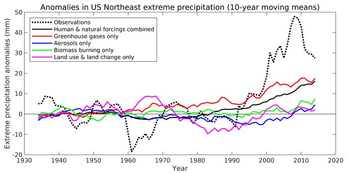


To isolate the causes of the extreme precipitation increase, the team used one set of global climate model simulations that reproduce historical climate by including the evolution of all natural and anthropogenic forcings. Natural forcings include solar radiation and volcanoes, while anthropogenic forcings include greenhouse gases, industrial aerosols (particulates from the burning of fossil fuels), aerosols from the burning of biomass, and land use and land change. In the other set of simulations, all of the forcings were included except for one of the four anthropogenic forcings. Through this "leave-one-out" approach, the researchers could isolate the effects of external forcings and internal variability (naturally occurring climate variations) on the observed changes of North Atlantic sea surface temperatures and Northeast extreme precipitation. The researchers then applied a statistical method called "optimal fingerprinting" that is frequently used in climate change research, to determine the extent to which external forcings have influenced regional climate.

The findings revealed that the extreme precipitation increase observed after 1996 was caused by greenhouse gases from human activity and a warmer North Atlantic Ocean. The North Atlantic Ocean warming since the 1990s, can be attributed to multidecadal variability, decreased industrial aerosols, and increased greenhouse gases. As air quality improved due to the Clean Air Act of 1970, aerosols that polluted the atmosphere and reflected sunlight, decreased. This reduced cooling from fewer aerosols, combined with warming from increased greenhouse gases from human activity, warmed the North Atlantic.

Huanping Huang et al, Rise in Northeast US extreme precipitation caused by Atlantic variability and climate change, Weather and Climate Extremes (2021).
https://www.sciencedirect.com/science/article/pii/S221209472100044X
There are 3 classes of people: those who see. Those who see when they are shown. Those who do not see

Insensible before the wave so soon released by callous fate. Affected most, they understand the least, and understanding, when it comes, invariably arrives too late

Fiat iustitia, et pereat mundus

vox_mundi

  • Multi-year ice
  • Posts: 10809
    • View Profile
  • Liked: 3572
  • Likes Given: 779
Re: Changes in Mid-Latitude Hydrology
« Reply #40 on: September 06, 2021, 02:55:43 PM »
Extreme Precipitation Events (EPE) Increase Significantly In Northwest China
https://phys.org/news/2021-09-extreme-precipitation-events-significantly-northwest.html


Fig. 1. Time series of annual precipitation amounts (a) and days (b) in northwest China, the contribution rate of extreme precipitation amounts to total precipitation amounts (c), and the contribution rate of extreme precipitation days to total precipitation days (d). Credit: HU Zeyong

... In recent years, extreme precipitation events (EPE) occurrences in Northwest China have increased significantly, causing more serious disasters and disrupting the fragile ecosystem of the arid biome. To understand what is driving more frequent extreme precipitation in Northwest China, scientists broke down several key atmospheric components, hoping to find the source of change.

According to the researchers, EPE have been the most significant contributor to the total precipitation in Northwest China. Within the arid region, the westerly and plateau zones have seen the most impactful EPE increase. Regarding seasonal effects, EPE have started earlier, and the last annual event is trending later. At the same time, they observed the opposite phenomenon in the monsoon regions of Southeast China.

Results indicate that summer atmospheric circulation, water vapor transport, and atmospheric instability over Northwest China varies greatly throughout the decades analyzed in the study. However, an abrupt increase in EPE is apparent just before and consistently after 1986. Conversely, the conditions in the monsoon zone suppress summer EPE development and occurrence after 1986.

In addition, the summer water vapor and atmospheric instability increased in the westerly zone and plateau zone. These characteristics created favorable conditions for increased occurrences of extreme precipitation in the westerly zone and plateau zone in summer.

Conversely, the upper-level convergence and lower-level divergence in the monsoon zone strengthened descending flow. Decreases in summer water vapor and atmospheric instability occurred in the monsoon zone after 1986. Hence, the environmental conditions in the monsoon zone may have prevented the occurrence and development of extreme precipitation in summer during 1986-2016.


Fig. 2. Spatial distribution of the trends for total precipitation (a, b) and EPE (c, d) in northwest China

Shan Lu et al, Changes of Extreme Precipitation and its Associated Mechanisms in Northwest China, Advances in Atmospheric Sciences (2021).
https://link.springer.com/article/10.1007%2Fs00376-021-0409-3
There are 3 classes of people: those who see. Those who see when they are shown. Those who do not see

Insensible before the wave so soon released by callous fate. Affected most, they understand the least, and understanding, when it comes, invariably arrives too late

Fiat iustitia, et pereat mundus