Increase In Extreme Precipitation In the Northeast U.S. Caused by Atlantic Variability and Climate Changehttps://phys.org/news/2021-08-extreme-precipitation-northeast-atlantic-variability.htmlRecent record-breaking rainfall across the northeastern United States is part of a larger trend. From Maine to West Virginia, the Northeast has seen an abrupt increase in extreme precipitation—heavy rain and snow resulting in about 1 to 2 inches of water in a day depending on location since 1996, which has coincided with warming sea surface temperatures in the North Atlantic. Northeast extreme precipitation is typically caused by tropical cyclones, thunderstorms along fronts, and extratropical cyclones like Nor'easters. A recent study published in
Weather and Climate Extremes finds that the increase in extreme precipitation after 1996 was caused by greenhouse gases from human activity and surface temperature variability of the North Atlantic Ocean, known as Atlantic variability.
... This study builds on earlier work by Huang and co-authors, which found that the Northeast has experienced a 53% increase in extreme precipitation since 1996, and that the primary driver of the increase is enhanced heavy rainfall from tropical cyclones. The team linked the enhanced heavy precipitation from tropical cyclones to both a warmer atmosphere, which increases the amount of water air can hold, and a warmer Atlantic Ocean, which creates stronger and more frequent hurricanes. "Our results demonstrate that multidecadal variability in Atlantic sea surface temperatures, an important driver of warming in the Atlantic, alongside anthropogenic greenhouse gases and aerosols, also contributed to the increase in Northeast extreme precipitation after 1996," added Huang.
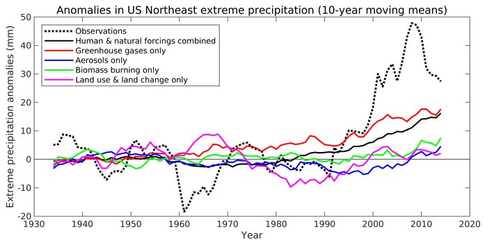
To isolate the causes of the extreme precipitation increase, the team used one set of global climate model simulations that reproduce historical climate by including the evolution of all natural and anthropogenic forcings. Natural forcings include solar radiation and volcanoes, while anthropogenic forcings include greenhouse gases, industrial aerosols (particulates from the burning of fossil fuels), aerosols from the burning of biomass, and land use and land change. In the other set of simulations, all of the forcings were included except for one of the four anthropogenic forcings. Through this "leave-one-out" approach, the researchers could isolate the effects of external forcings and internal variability (naturally occurring climate variations) on the observed changes of North Atlantic sea surface temperatures and Northeast extreme precipitation. The researchers then applied a statistical method called "optimal fingerprinting" that is frequently used in climate change research, to determine the extent to which external forcings have influenced regional climate.
The findings revealed that the extreme precipitation increase observed after 1996 was caused by greenhouse gases from human activity and a warmer North Atlantic Ocean. The North Atlantic Ocean warming since the 1990s, can be attributed to multidecadal variability, decreased industrial aerosols, and increased greenhouse gases. As air quality improved due to the Clean Air Act of 1970, aerosols that polluted the atmosphere and reflected sunlight, decreased. This reduced cooling from fewer aerosols, combined with warming from increased greenhouse gases from human activity, warmed the North Atlantic.
Huanping Huang et al,
Rise in Northeast US extreme precipitation caused by Atlantic variability and climate change,
Weather and Climate Extremes (2021).
https://www.sciencedirect.com/science/article/pii/S221209472100044X


