The quest to document ice quality took another evening over my CAD screen.
This is the SE quadrant with a radius of 50 km on the North Pole today on MODIS.
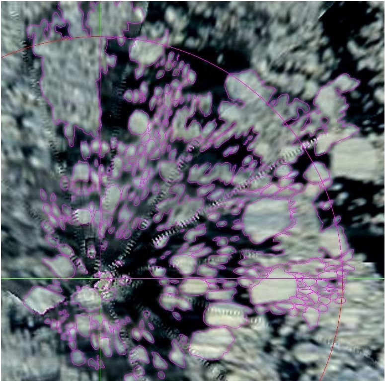
For 27 August CT showed this at about 65-70% concentration. What UB supposes for 27 August is hard to tell, because their Pole-hole is large (radius about 100 km). But both to the W and E adjacent swaths are yellow and green, also suggesting 65-70% concentration.
As you can see, I’ve digitized polylines around obviously unified floes. As their reflection fades over about three pixelwidths, the lines are arbitrary. That’s what should be kept in mind when interpreting the CAD-numbers.
What did the program find?
The area covered by the quadrant is app. 1964 km2. There were 177 surfaces, the smallest just about pixel-width covering about four soccer-fields. The biggest were undivisible stretches but obvious thick packed rubble. When these two swaths are set apart, the largest floe is app. 70 km2, the average of the lot is under 4 km2.
CAD found 982 km2 ice, about 50%.
As the total edge-length is app. 1440 km1, the possible uncertainty through the fading can be fathomed. Given the half of the fading zone, it could be as much as 500 km2.
I presume the fading zone might feature small rubble, nilas e.o.
The area that is open for sure is at least around 500 km2.
When would have been the last time to have shown so much open water over a relevant distance?
BTW, when counting in the fading-zone, both UB and CT are quite accurate over the place today...


