Support the Arctic Sea Ice Forum and Blog

Author Topic: Volcanoes  (Read 85703 times)

oren

  • First-year ice
  • Posts: 9817
    • View Profile
  • Liked: 3588
  • Likes Given: 3940
Re: Volcanoes
« Reply #50 on: June 09, 2018, 09:37:32 PM »
You come from the ASIF of course. What else?

Sigmetnow

  • Multi-year ice
  • Posts: 25901
    • View Profile
  • Liked: 1159
  • Likes Given: 430
Re: Volcanoes
« Reply #51 on: June 16, 2018, 02:33:32 PM »
Kilauea: Lava per second.

“#Number time. #Fissure8 #lava effusion rate estimates indicate ~100 cubic m/s. OR...
~26,000 US gallons/s
~12 commercial dump trucks/s

This morning's photos - low fountains, elongate cone, and robust ocean entry plume. #KilaueaErupts #Kilauea #KilaueaEruption #LERZ ”
https://twitter.com/USGSVolcanoes/status/1006957055280758785
Image below. Others at the link.
People who say it cannot be done should not interrupt those who are doing it.

Archimid

  • Young ice
  • Posts: 3511
    • View Profile
  • Liked: 899
  • Likes Given: 206
Re: Volcanoes
« Reply #52 on: June 20, 2018, 03:10:06 PM »
Quick report from ground zero in Guatemala where we were bringing sandwiches and drinks to families.

This video is not for the faint of heart. If any of you have money you would like to give to charity, this is it. This man is a hero chef and indirectly  a hero journalist. Given climate change, there is a good chance that he might end up feeding us at some point.

https://twitter.com/chefjoseandres/status/1009204569279254533
I am an energy reservoir seemingly intent on lowering entropy for self preservation.

gerontocrat

  • Multi-year ice
  • Posts: 20576
    • View Profile
  • Liked: 5304
  • Likes Given: 69
Re: Volcanoes
« Reply #53 on: July 14, 2018, 01:20:05 PM »
Kilauea Volcano, Big Island, Hawaii.

The story that will not end?

http://bigislandnow.com/2018/07/13/lava-island-emerges/

(click on the images)
"Para a Causa do Povo a Luta Continua!"
"And that's all I'm going to say about that". Forrest Gump
"Damn, I wanted to see what happened next" (Epitaph)

vox_mundi

  • Multi-year ice
  • Posts: 10233
    • View Profile
  • Liked: 3517
  • Likes Given: 754
Re: Volcanoes
« Reply #54 on: November 26, 2018, 06:23:30 PM »
Large Volcanic Eruption Shook Deception Island 3,980 Years Ago
https://phys.org/news/2018-11-large-volcanic-eruption-shook-deception.html


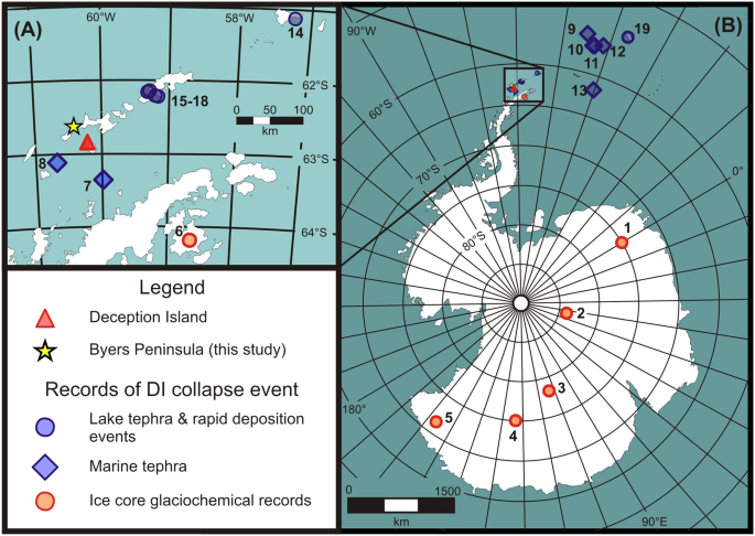
A large volcanic eruption shook Deception Island in Antarctica 3,980 years ago, and not 8,300, as it was previously thought, according to an international study published in Scientific Reports, in which researchers from the Institute of Earth Sciences Jaume Almera (ICTJA-CSIC) have participated. This event was the largest eruption in the austral continent during the Holocene (the last 11,700 years after the last great glaciation on Earth), and was comparable in volume of ejected rock to the Tambora volcano eruption in 1815. The eruption formed the caldera of the volcano, one of the most active in Antarctica, with more than 20 eruptions registered in the last 200 years


According to the new study, a volcanic caldera collapse took place 3980 years ago. 
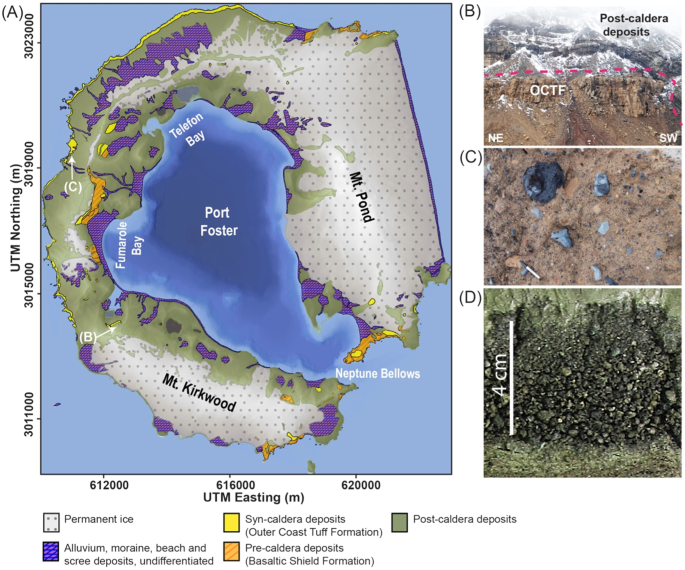
The emptying of the magmatic chamber, the zone of magma accumulation that fueled the eruption, during this violent eruptive event caused a sudden pressure drop, triggering the collapse of the upper part of the volcano. As a result, a depression between eight and 10 kilometers in diameter was formed, which now gives Deception Island its particular horseshoe shape. The caldera collapse would have caused a seismic event of great magnitude, the traces of which were recorded in the sediments accumulated in the lake bottoms of Livingstone Island.

The study estimates that the eruption had a volcanic explosive index (VEI) around six, which possibly makes it the largest known Holocene eruptive episode in the Antarctic continent.
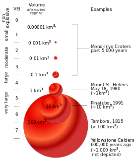


"This colossal episode of eruptive caldera collapse ejected between 30 and 60 cubic kilometers of ash, comparable in volume to the eruption of the Tambora volcano in 1815, an event that is attributed to a global temperature cooling that resulted in a series of bad harvests in Europe, in what is known as the 'year without summer,'" explains Adelina Geyer, ICTJA-CSIC researcher and co-author of the study.

Open Access: Antoniades, D., Giralt, S., Geyer, A., Alvarez-Valero, A.M., Pla-Rabes, S., Granados, I., Liu, E.J., Toro, M., Smellie, J.L. and Oliva, M. (2018). The timing and widespread effects of the largest Holocene volcanic eruption in Antarctica. Scientific Reports. (8) 1.

Read more at: https://phys.org/news/2018-11-large-volcanic-eruption-shook-deception.html#jCp

---------------------------------
I wonder if this is related ...

4.2 Kiloyear Event
https://en.wikipedia.org/wiki/4.2_kiloyear_event

The 4.2-kiloyear BP aridification event was one of the most severe climatic events of the Holocene period.[1] It defines the beginning of the current Meghalayan age in the Holocene epoch. Starting in about 2200 BC, it probably lasted the entire 22nd century BC. It has been hypothesised to have caused the collapse of the Old Kingdom in Egypt as well as the Akkadian Empire in Mesopotamia, and the Liangzhu culture in the lower Yangtze River area.[2][3] The drought may also have initiated the collapse of the Indus Valley Civilisation, with some of its population moving southeastward to follow the movement of their desired habitat,[4] as well as the migration of Indo-European speaking people into India.[5]

A phase of intense aridity about 4.2 ka BP is recorded across North Africa,[6] the Middle East,[7] the Red Sea,[8] the Arabian Peninsula,[9] the Indian subcontinent,[4] and midcontinental North America.[10] Glaciers throughout the mountain ranges of western Canada advanced at about this time.[11] Evidence has also been found in an Italian cave flowstone,[12] the Kilimanjaro Ice sheet,[13] and in Andean glacier ice.[14] The onset of the aridification in Mesopotamia about 4100 BP also coincided with a cooling event in the North Atlantic, known as Bond event 3.[1][15][16] Despite this, evidence for the 4.2 kyr event in northern Europe is ambiguous, suggesting the origin and effect of this event is spatially complex.[17]


Central Greenland reconstructed temperature. Unlike the 8.2-kiloyear event, the 4.2-kiloyear event has no prominent signal in the Gisp2 ice core that has an onset at 4.2 ka BP.

Hypothesis: Cooling in the SH? > change in ocean circulation overturning? > change in AMOC? > change in global climate?
“There are three classes of people: those who see. Those who see when they are shown. Those who do not see.” ― anonymous

Insensible before the wave so soon released by callous fate. Affected most, they understand the least, and understanding, when it comes, invariably arrives too late

oren

  • First-year ice
  • Posts: 9817
    • View Profile
  • Liked: 3588
  • Likes Given: 3940
Re: Volcanoes
« Reply #55 on: November 26, 2018, 06:39:13 PM »
I wonder how such a change in timing is not decided by Antarctic ice cores. 4000 years ago should be well recorded in such cores, afaik.

Sigmetnow

  • Multi-year ice
  • Posts: 25901
    • View Profile
  • Liked: 1159
  • Likes Given: 430
Re: Volcanoes
« Reply #56 on: November 28, 2018, 07:33:46 PM »
This is fascinating, in a volcano/earthquake kind of way. :)
Apparently it was caused by movement of magma, rather than the usual abrupt tectonic shaking.

Strange earthquake waves rippled around Earth, and nobody knows why
https://www.nationalgeographic.com/science/2018/11/strange-earthquake-waves-rippled-around-world-earth-geology/
People who say it cannot be done should not interrupt those who are doing it.

Brigantine

  • Frazil ice
  • Posts: 345
    • View Profile
  • Liked: 104
  • Likes Given: 345
Re: Volcanoes
« Reply #57 on: November 29, 2018, 12:13:17 AM »
If it's at 1/17 Hz and no other frequencies, then I'm not at all surprised that no one felt them.

Slow Slip Earthquakes are a relatively recent discovery, 16 years ago or something. AFAIK they aren't very well understood yet. I have a feeling this 1/17 Hz Mayotte event is going to teach us a bunch of things we didn't know yet.

For now I'll just call it the Magma Flute  :P
« Last Edit: November 29, 2018, 12:23:33 AM by Brigantine »

vox_mundi

  • Multi-year ice
  • Posts: 10233
    • View Profile
  • Liked: 3517
  • Likes Given: 754
Re: Volcanoes
« Reply #58 on: December 23, 2018, 09:00:02 AM »
Krakatoa Volcano (Sunda Strait, Indonesia): Possible Major Eruption With Ash to 55,000 ft Following Deadly Tsunami
https://www.volcanodiscovery.com/krakatau/news/72494/Krakatoa-volcano-Sunda-Strait-Indonesia-possible-major-eruption-with-ash-to-55000-ft-following-deadl.html


A major explosive eruption may have occurred at the volcano earlier this morning. VAAC Darwin spotted a large cloud, possibly an ash plume from the eruption reaching approx. 55,000 ft (15 km) altitude and drifting S and SW.

The current eruptive phase of the volcano seems to be in fact rather strong. A new lava flow is reaching the sea and strong explosive activity, likely pulsating lava fountains are occurring at the summit vent.


--------------------

Indonesia Tsunami Hits Sunda Strait After Krakatoa Eruption
https://www.bbc.com/news/amp/world-asia-46663158

Volcanologist Jess Phoenix told the BBC that when volcanoes erupt, hot magma pushes underground and can displace and break through colder rock. This can trigger a landslide.

But because part of Krakatoa is underwater, she said "instead of just causing a landslide, you get an undersea landslide which pushes water as it moves." This can then cause a tsunami.

“When the flanks [side] of volcanoes collapse, or pyroclastic flows enter the ocean, they can also create waves that become tsunamis.

“Flank collapse may have generated the biggest tsunamis on earth (excluding the very rare ones from asteroid impacts into the ocean).”
« Last Edit: December 23, 2018, 09:39:59 AM by vox_mundi »
“There are three classes of people: those who see. Those who see when they are shown. Those who do not see.” ― anonymous

Insensible before the wave so soon released by callous fate. Affected most, they understand the least, and understanding, when it comes, invariably arrives too late

Forest Dweller

  • Frazil ice
  • Posts: 138
    • View Profile
  • Liked: 6
  • Likes Given: 32
Re: Volcanoes
« Reply #59 on: December 23, 2018, 02:31:40 PM »
Incoming news of the Anak Krakatau now mentioning Sumatra was also hit by tsunami waves.
Runup height reported from Java at 19 meters and death toll steadily rising.
Seismologists calling for a re-scan of the ocean floor.
Tsunami alarm did not go off until the waves had struck already.
What worries me most is the fact that the last 50 Javanese rhino live on the peninsula there at Ujong Kulon NP.
Contrary to the other areas that is a low area, mangroves, marshes, river estuaries where tsunami would have much bigger impacts.
The rhino are a familiar sight on the beach or use marshy areas and any loss could be disastrous for the species...

Forest Dweller

  • Frazil ice
  • Posts: 138
    • View Profile
  • Liked: 6
  • Likes Given: 32
Re: Volcanoes
« Reply #60 on: December 23, 2018, 03:29:32 PM »
Al Jazeera article about Sunda strait tsunami;
Although the picture of Krakatoa is from September it looks as if there has already been collapse of the south-east flank here on Anak Krakatau.
We will have to wait for clouds to disappear from the area and compare on satellite.
The rhino area is according to Indonesian Disaster Management Board in the worst affected area.

https://www.aljazeera.com/indepth/inpictures/deadly-tsunami-hits-coastal-towns-indonesia-sunda-strait-181223083551404.html

ArcticMelt1

  • New ice
  • Posts: 77
    • View Profile
  • Liked: 15
  • Likes Given: 1
Re: Volcanoes
« Reply #61 on: December 23, 2018, 03:36:34 PM »
Wikipedia writes that now the height of the volcano is close to a kilometer. As the mountains grow fast, almost as fast as people build skyscrapers.
For comparison, before the 1883 explosion, the height of the volcano was about 3 kilometers.

ArcticMelt1

  • New ice
  • Posts: 77
    • View Profile
  • Liked: 15
  • Likes Given: 1
Re: Volcanoes
« Reply #62 on: December 23, 2018, 04:13:23 PM »
However, this is incorrect information. 2-3 km was the height of the volcano to the eruption of 535 year. Now the volcano explodes more often.

https://earthsky.org/earth/view-from-space-anak-krakatau-volcano-eruption

Quote
Anak Krakatau currently has a radius of about 2 kilometers (6562 feet) and a height of 324 meters (1063 feet) above sea level, according to Wikipedia. Those data may need to be updated as a variety of September 2012 news reports list the current height of Anak Krakatau at 405 meters (1330 feet).

Anak Krakatau is growing in height at an average rate of about 5 meters (16 feet) per year. Before the historic 1883 eruption, Anak Krakatau stood at approximately 813 meters (2667 feet) above sea level, according to the Global Volcanism Program.

Forest Dweller

  • Frazil ice
  • Posts: 138
    • View Profile
  • Liked: 6
  • Likes Given: 32
Re: Volcanoes
« Reply #63 on: December 23, 2018, 04:14:59 PM »
To be honest, and off topic perhaps...all i care about for now is those almost extinct Javan rhino.
I worked hard with the WWF researchers to save their relatives in Vietnam, extinct April 29th 2010.
With the program directors we set up a project to better represent other National Parks, whose websites are all run by stupid travel agencies.
Ujong Kulon would have been the first NP to receive a free website from me focusing on wildlife instead of tourist dollars. Staff training on the computer and so on...
The reason those Javan rhino were not easily poached so far has to do with the fact it is a peninsula and hard to reach for poachers...now a tsunami comes along.
If i learn those guys were victims i will be really pissed off and sad.
If anyone has news in the coming period about the park please share here thanx.

ArcticMelt1

  • New ice
  • Posts: 77
    • View Profile
  • Liked: 15
  • Likes Given: 1
Re: Volcanoes
« Reply #64 on: December 23, 2018, 05:21:36 PM »
As I understand it, the worst has not happened yet. And the threat of a complete explosion of the entire volcano in this year may pass.

If the volcano explodes like in 1883, then the whole world will know about it. The power of explosions in 1883 was about 200 megatons.

vox_mundi

  • Multi-year ice
  • Posts: 10233
    • View Profile
  • Liked: 3517
  • Likes Given: 754
Re: Volcanoes
« Reply #65 on: December 23, 2018, 05:45:06 PM »
It's possible that the rhinos may have sensed the tsunami and gone to higher ground - if available.

The 2004 Boxing Day Tsunami suggests animals may sense the infrasound from these events ...
Quote
... Some 230,000 people across fourteen coastal countries died, but, in the aftermath, locals and rescuers in certain areas noted a conspicuous absence of animal casualties. In the following weeks and months, stories emerged of some animals acting oddly just before the tsunami hit: Eyewitnesses in Sri Lanka and Thailand told of elephants that trumpeted before seeking higher ground, dogs that refused to go outside, and flamingos that suddenly abandoned low-lying nesting areas.
An article from 2017 describes the scenario your suggesting:

TSUNAMIS COULD WIPE OUT THE REMAINING 62 JAVAN RHINOS
https://www.newsweek.com/tsunamis-volcanoes-javan-rhinos-extinction-608595?amp=1

Quote
... In the largest survey to date, researchers placed motion-activated cameras at nearly 200 locations throughout the park. After analyzing the large amount of video collected, they determined that only 62 Javan rhinos remain in the wild. These few live in low-lying areas that could be inundated by a tsunami, researchers write in a study describing their findings, published in the journal Conservation Letters .
http://onlinelibrary.wiley.com/doi/10.1111/conl.12366/epdf

... The researchers conclude that a tsunami that made it to 10 meters, or 33 feet, above sea level would threaten 80 percent of the rhinos' territory. 
Quote
... The park also happens to sit about 50 miles from one of the world’s most fearsome volcanoes: Anak Krakatoa. It is the “offspring” of the Krakatoa volcano which erupted in 1883, the most cataclysmic in modern history, the reverberations of which were felt around the world. Anak Kratoa, which means “childs of Krakatoa,” has been growing from the destroyed remnants of this volcanic island ever since. If it erupts before 2040 scientists estimate it could create tsunamis that reach up to nearly 70 feet above sea level. If it erupts after then, the waves could rise to heights of almost 100 feet.

For this reason, a second population of Javan rhinos needs to be established to increase the likelihood of their survival, Gerber says.
 

https://onlinelibrary.wiley.com/doi/epdf/10.1111/conl.12366
“There are three classes of people: those who see. Those who see when they are shown. Those who do not see.” ― anonymous

Insensible before the wave so soon released by callous fate. Affected most, they understand the least, and understanding, when it comes, invariably arrives too late

Sigmetnow

  • Multi-year ice
  • Posts: 25901
    • View Profile
  • Liked: 1159
  • Likes Given: 430
Re: Volcanoes
« Reply #66 on: December 23, 2018, 05:52:50 PM »
Dr Janine Krippner (@janinekrippner)
12/23/18, 10:01 AM
It looks like the magma/lava at Anak Krakatau is now interacting with the sea water, causing these dark, steam-rich cock's-tail plumes:
https://twitter.com/janinekrippner/status/1076855253948121088

Mt. Krakatoa Eruption, one hour ago. Credit to Capt. Mykola from Susi Air #PrayForBanten #prayforanyer #PrayForLampung #PrayForSelatSunda #prayforindonesia #Krakatau #TsunamiSelatSunda #TsunamiAnyer #tsunamibanten #TsunamiLampung
https://twitter.com/hudasafiro/status/1076805858518982657
Video at the link: arial view of eruption


Simon Carn: "Latest #Sentinel5P #Tropomi SO2 data shows relatively small SO2 emission from the #Krakatau #eruption (~0.025 Tg). Much too low for any climate impact. Coupled w/ intense lightning & ice/water-rich plume suggests a 'wet' eruption with significant magma-seawater interaction.”
https://twitter.com/simoncarn/status/1076849669924376576
Image below.
People who say it cannot be done should not interrupt those who are doing it.

Forest Dweller

  • Frazil ice
  • Posts: 138
    • View Profile
  • Liked: 6
  • Likes Given: 32
Re: Volcanoes
« Reply #67 on: December 23, 2018, 05:54:59 PM »
Thanks Vox_mundi.
I'm hearing reports now that the wave was smaller, let's hope so.
I did not know other researchers had studied the tsunami threat to these little rhino.
It really does not take 80% of them to die by a 10 meter tsunami however.
If just a few animals with breeding potential are gone that could well be the end of them.
Fingers crossed....XXXXXXXXXXXXXXXXXX

vox_mundi

  • Multi-year ice
  • Posts: 10233
    • View Profile
  • Liked: 3517
  • Likes Given: 754
Re: Volcanoes
« Reply #68 on: December 23, 2018, 08:10:44 PM »
Large Part of Anak Krakatau Has Collapsed Into the Sea - Reconstruction of the Eruption 
https://www.volcanodiscovery.com/krakatau/news/72510/Large-part-of-Anak-Krakatau-has-collapsed-into-the-sea-reconstruction-of-the-eruption.html

Quote
First visual information about the situation on Anak Krakatau island group itself has come in, revealing that a large part of Anak Krakatau's SW flank has collapsed, which most likely is the trigger for last night's tsunami.

Quote
...  a rough reconstruction of the events:

#1 A new surge of magma arrives in the upper conduit of Anak Krakatau from around 20-21 Dec, causing increasing explosive and effusive activity - strombolian explosions or lava fountains, and lava flow emission - from the summit vent. This activity probably reached its peak on the evening of 22 Dec, when it was clearly visible by naked eye from more than 40 km away on the coast.

#2 In the evening of 22 Dec, lava fountains fed flows that reached the sea, probably on the south or southeast shores of Anak Krakatau, in similar locations as during previous episodes this year.

#3 Around 21:00 local time, the weight of rapidly accumulated lava on the subaerial and submerged cone of Anak Krakatau triggered an instability and a larger landslide removed a part of the southwestern cone - a flank collapse occurred. This rapid displacement caused the (small, but devastating) tsunami which reached the Java coast around 21:30 (local time).


#4 As a consequence, sea water gained access to large masses of hot rocks and possibly the conduit itself, triggering an ongoing series of steam explosions that produced the steam and ash plume first observed later this morning on satellite data and seen in this video: 

 
Erosion of material from the ongoing explosive activity and along the new shoreline continues to eat away parts of the island.   
« Last Edit: December 24, 2018, 04:38:53 AM by vox_mundi »
“There are three classes of people: those who see. Those who see when they are shown. Those who do not see.” ― anonymous

Insensible before the wave so soon released by callous fate. Affected most, they understand the least, and understanding, when it comes, invariably arrives too late

ArcticMelt1

  • New ice
  • Posts: 77
    • View Profile
  • Liked: 15
  • Likes Given: 1
Re: Volcanoes
« Reply #69 on: December 23, 2018, 08:33:34 PM »
https://www.volcanodiscovery.com/krakatau/news/72510/Large-part-of-Anak-Krakatau-has-collapsed-into-the-sea-reconstruction-of-the-eruption.html

Quote
What will come next?
This is difficult to say, but at least to a large extent it will depend on how much magma continues to rise, whether new collapses occur and so on. A possibility of even larger explosions, pyroclastic flows, tsunamis is clearly increased.
The alert level of the volcano was raised to red.

vox_mundi

  • Multi-year ice
  • Posts: 10233
    • View Profile
  • Liked: 3517
  • Likes Given: 754
Re: Volcanoes
« Reply #70 on: December 23, 2018, 10:09:11 PM »
Forest Dweller: Here's a local article on the rhinos after the  tsunami. Excuse the Google translation - it's Javanese

Pasca Tsunami Selat Sunda, Pemprov Banten Khawatir soal Badak Cula Satu di Ujung Kulon
https://www.google.com/amp/s/news.okezone.com/amp/2018/12/23/340/1995129/pasca-tsunami-selat-sunda-pemprov-banten-khawatir-soal-badak-cula-satu-di-ujung-kulon

Sunday 23 December 2018 16:37 WIB
After the Sunda Straits Tsunami, Banten Provincials Worry about One Horned Rhinos at Ujung Kulon
Journalist - Anggun Tifani
 
TANGERANG - After the Tsunami that struck the coastal area in the Sunda Strait, along the West Coast of Banten Province. The Provincial Government of Banten, also worried about the condition of the one horned rhinoceros in Ujung Kulon National Park.

Head of application and public communication Banten Diskominfo and Statistics of Banten Province Amal Herawan Budhi, said they are currently checking the condition of these rare animals, after the tsunami.

"Yes, we just do not know, It's what we're talking about," Amal told Okezone, Sunday (23/12/2018).

Amal explained, most likely the area of ​​Ujung Kulon National Park, was affected by the tsunami that occurred Saturday (22/12/2018) last night.

"The area is clearly exposed to Tanjung Lesung and the Sumur area, Ujung Kulon is in Sumur Subdistrict, but so far there has been no reports," said Amal.

So far, Amal has said that the death toll continues to grow. It also continues to monitor the existence of a number of islands in its territory.

"The latest data on the death toll continues to grow, the most victims in Carita and Jiput, according to those who are currently monitoring the Sangiang island," he said.
-----------------------

Natural Disasters Pose Grave Threat to Planet's Last Javan Rhinos 
https://www.sciencedaily.com/releases/2017/05/170510115324.htm

« Last Edit: December 24, 2018, 06:24:36 PM by vox_mundi »
“There are three classes of people: those who see. Those who see when they are shown. Those who do not see.” ― anonymous

Insensible before the wave so soon released by callous fate. Affected most, they understand the least, and understanding, when it comes, invariably arrives too late

wili

  • Young ice
  • Posts: 3342
    • View Profile
  • Liked: 602
  • Likes Given: 409
Re: Volcanoes
« Reply #71 on: December 24, 2018, 01:25:57 PM »
FD wrote: "Runup height reported from Java at 19 meters..." then later "...10 meters..."

Where are you getting these figures from? I don't see anything that mentions heights more than 10 feet (which is plenty bad enough).
"A force de chercher de bonnes raisons, on en trouve; on les dit; et après on y tient, non pas tant parce qu'elles sont bonnes que pour ne pas se démentir." Choderlos de Laclos "You struggle to come up with some valid reasons, then cling to them, not because they're good, but just to not back down."

ArcticMelt1

  • New ice
  • Posts: 77
    • View Profile
  • Liked: 15
  • Likes Given: 1
Re: Volcanoes
« Reply #72 on: December 24, 2018, 02:21:19 PM »
Another scientific work on the possible consequences of the complete collapse of a young volcano.

http://sp.lyellcollection.org/content/361/1/79

Quote
Tsunami hazard related to a flank collapse of Anak Krakatau Volcano, Sunda Strait, Indonesia

T. Giachetti, R. Paris, K. Kelfoun and B. Ontowirjo
Geological Society, London, Special Publications, 361, 79-90, 3 January 2012, https://doi.org/10.1144/SP361.7

Numerical modelling of a rapid, partial destabilization of Anak Krakatau Volcano (Indonesia) was performed in order to investigate the tsunami triggered by this event. Anak Krakatau, which is largely built on the steep NE wall of the 1883 Krakatau eruption caldera, is active on its SW side (towards the 1883 caldera), which makes the edifice quite unstable. A hypothetical 0.280 km3 flank collapse directed southwestwards would trigger an initial wave 43 m in height that would reach the islands of Sertung, Panjang and Rakata in less than 1 min, with amplitudes from 15 to 30 m. These waves would be potentially dangerous for the many small tourist boats circulating in, and around, the Krakatau Archipelago. The waves would then propagate in a radial manner from the impact region and across the Sunda Strait, at an average speed of 80–110 km h−1. The tsunami would reach the cities located on the western coast of Java (e.g. Merak, Anyer and Carita.) 35–45 min after the onset of collapse, with a maximum amplitude from 1.5 (Merak and Panimbang) to 3.4 m (Labuhan). As many industrial and tourist infrastructures are located close to the sea and at altitudes of less than 10 m, these waves present a non-negligible risk. Owing to numerous reflections inside the Krakatau Archipelago, the waves would even affect Bandar Lampung (Sumatra, c. 900 000 inhabitants) after more than 1 h, with a maximum amplitude of 0.3 m. The waves produced would be far smaller than those occurring during the 1883 Krakatau eruption (c. 15 m) and a rapid detection of the collapse by the volcano observatory, together with an efficient alert system on the coast, would possibly prevent this hypothetical event from being deadly.

« Last Edit: December 24, 2018, 02:38:41 PM by ArcticMelt1 »

ArcticMelt1

  • New ice
  • Posts: 77
    • View Profile
  • Liked: 15
  • Likes Given: 1
Re: Volcanoes
« Reply #73 on: December 24, 2018, 02:34:45 PM »
A similar tsunami has already happened there in 1981 (there were no casualties?).

Quote
One possible major hazard emerging from Anak Krakatau would be a tsunami triggered by a collapse of its flank, as the volcano is partly built on a steep wall of the caldera resulting from the 1883 eruption. A small tsunami (c. 2 m high) was experienced on Rakata Island in October 1981 during an awakening of Anak Krakatau (Camus et al. 1987). In the present study, we numerically simulate a sudden southwestwards destabilization of a large part of the Anak Krakatau Volcano, and the subsequent tsunami formation and propagation. We show results concerning the time of arrival and the amplitude of the waves produced, both in the Sunda Strait and on the coasts of Java and Sumatra. We then discuss the relationships between the morphology of Anak Krakatau, the locations of the surrounding islands, the bathymetry of the strait and the triggered waves.

There is a bridge project in the strait

Quote
In October 2007, the Indonesian government planned the construction of a 30 km road and railway connection between the islands of Sumatra and Java (the Selat Sunda Bridge), across the 26 km Sunda Strait, at an altitude of 70 m asl (above sea level). In 2009, the ‘pre-feasibility’ study for this 10 billion dollar project was completed and the construction is expected to begin in 2012. Owing to the seismic and volcanic activity in the Sunda region, this project faces many challenges. Krakatau Volcano is located only 40 km away from the future bridge. Some of the bridge's piles may suffer from tsunamis crossing the Sunda Strait, therefore such hazards need to be quantified.
« Last Edit: December 24, 2018, 02:41:42 PM by ArcticMelt1 »

vox_mundi

  • Multi-year ice
  • Posts: 10233
    • View Profile
  • Liked: 3517
  • Likes Given: 754
Re: Volcanoes
« Reply #74 on: December 26, 2018, 05:00:50 PM »
FD - the rhinos are safe - extinction postponed for another day ...

Tsunami hits Sunda Strait Beach, What is the fate of Javan rhinos? - (use Google Translate)
http://www.mongabay.co.id/2018/12/25/tsunami-hantam-pantai-selat-sunda-bagaimana-nasib-badak-jawa/

Quote
Mamat Rahmat, Head of the Ujung Kulon National Park (TNUK), confirmed that the tsunami had reached the national park area. ... "Estimates in the field, water reaches 20-50 meters from the shoreline," ... Mamat stated that the condition of the Javan Rhino ( Rhinoceros sondaicus) was safe after the tsunami.

Rhinos gathered in the middle of the forest and the southern edge of the coast. While those [beaches] affected by the tsunami are in the north - the Sumur Subdistrict, Pandeglang Regency, Banten, which is the entrance to TNUK, is the area directly affected by the disaster.


Infrared camera monitoring shows that the rhinos spent most of their time in areas with an elevation of between 9-15 meters and distances to the coastline of 412-855 meters.

Monitoring the condition of the area affected by the tsunami was carried out directly by WWF-Indonesia National Rhino Officer Ridwan Setiawan , while evacuating the communities around Ujung Kulon.
Quote

-----------------------

Mount Etna Has First 'Flank Eruption' In Over a Decade
https://www.bbc.com/news/world-europe-46675110

Quote
Europe's most active volcano, Mount Etna in Sicily, erupted on Monday, with officials reporting more than 130 earthquakes of up to 4.3 in magnitude.

The Mount Etna observatory said lava had spewed from a new fracture near its south-eastern crater.

« Last Edit: December 26, 2018, 10:13:26 PM by vox_mundi »
“There are three classes of people: those who see. Those who see when they are shown. Those who do not see.” ― anonymous

Insensible before the wave so soon released by callous fate. Affected most, they understand the least, and understanding, when it comes, invariably arrives too late

Sigmetnow

  • Multi-year ice
  • Posts: 25901
    • View Profile
  • Liked: 1159
  • Likes Given: 430
Re: Volcanoes
« Reply #75 on: December 26, 2018, 08:56:12 PM »
Dr Janine Krippner: "Satellite images of Anak #Krakatau in the Sunda Strait show us that part of the volcano is gone. It appears the failure of the southwest side of Krakatau triggered the tsunami on 22/12/2018.”
https://twitter.com/janinekrippner/status/1077920520371388417
Image below.
People who say it cannot be done should not interrupt those who are doing it.

Pmt111500

  • Guest
Re: Volcanoes
« Reply #76 on: December 27, 2018, 07:46:06 AM »
Dr Janine Krippner: "Satellite images of Anak #Krakatau in the Sunda Strait show us that part of the volcano is gone. It appears the failure of the southwest side of Krakatau triggered the tsunami on 22/12/2018.”
https://twitter.com/janinekrippner/status/1077920520371388417
Image below.
Thanks for the radar images. Looks like about one third of the island got resurfaced and about 1/8 dropped wholly under sea. Whatever happened below surface  has likely been as massive or more. But at least 1km2 of ground of unknown thickness is now under sea.

Tor Bejnar

  • Young ice
  • Posts: 4606
    • View Profile
  • Liked: 879
  • Likes Given: 826
Re: Volcanoes
« Reply #77 on: December 29, 2018, 05:17:00 AM »
via a comment in Weather Underground's Cat 6 blog comes this GIF from
https://uploads.disquscdn.com/images/07cf71099d83b967d55f24914389de3c6c19b4424f99c86d56b2a8a52c3ce2bf.gif
It clearly shows the lower right corner going AWAL.

Arctic ice is healthy for children and other living things because "we cannot negotiate with the melting point of ice"

vox_mundi

  • Multi-year ice
  • Posts: 10233
    • View Profile
  • Liked: 3517
  • Likes Given: 754
Re: Volcanoes
« Reply #78 on: December 29, 2018, 08:46:49 AM »
BBC: Anak Krakatau: Indonesian Volcano's Dramatic Collapse   
https://www.bbc.com/news/science-environment-46707731

Quote
...  Researchers have examined satellite images of Anak Krakatau to calculate the amount of rock and ash that sheared off into the sea.

They say the volcano has lost more than two-thirds of its height and volume during the past week.

Much of this missing mass could have slid into the sea in one movement.

What was once a volcanic cone standing some 340m high is now just 110m tall, says the PVMBG.

In terms of volume, 150-170 million cubic metres of material has gone, leaving only 40-70 million cubic metres still in place.   
 
“There are three classes of people: those who see. Those who see when they are shown. Those who do not see.” ― anonymous

Insensible before the wave so soon released by callous fate. Affected most, they understand the least, and understanding, when it comes, invariably arrives too late

Pmt111500

  • Guest
Re: Volcanoes
« Reply #79 on: December 29, 2018, 12:18:08 PM »
Okay, my initial estimate was way too conservative. Over half of the island went down on one crash...
I understand Phys.org has the best numbers currently known, some of which I've seen stated also by local scholars and officials.
https://m.phys.org/news/2018-12-indonesian-tsunami-volcano-lost-two-thirds.html

« Last Edit: December 29, 2018, 04:11:04 PM by Pmt111500 »

Sigmetnow

  • Multi-year ice
  • Posts: 25901
    • View Profile
  • Liked: 1159
  • Likes Given: 430
Re: Volcanoes
« Reply #80 on: December 30, 2018, 05:56:12 PM »
Sotiris Valkaniotis: "A comparison of before and after #Sentinel2 images show the immense change of #AnakKrakatau island morphology. #Landslide flank collapse on the west and new deposits to the east. Yellow is coastline digitized from Nov 16 imagery, red is the latest of Dec 29.”
https://twitter.com/SotisValkan/status/1078971620692279297
Image below.
People who say it cannot be done should not interrupt those who are doing it.

vox_mundi

  • Multi-year ice
  • Posts: 10233
    • View Profile
  • Liked: 3517
  • Likes Given: 754
Re: Volcanoes
« Reply #81 on: January 04, 2019, 02:22:54 AM »
https://gizmodo.com/satellite-images-show-shattered-remains-of-indonesia-s-1831459776


Vivid new satellite photos of Anak Krakatau are providing our first cloud-free glimpse of the island volcano that triggered a devastating tsunami in Indonesia late last month. As the photos show, a gaping lagoon now appears where a 1,115-foot-high volcanic mountain once stood.
“There are three classes of people: those who see. Those who see when they are shown. Those who do not see.” ― anonymous

Insensible before the wave so soon released by callous fate. Affected most, they understand the least, and understanding, when it comes, invariably arrives too late

Sigmetnow

  • Multi-year ice
  • Posts: 25901
    • View Profile
  • Liked: 1159
  • Likes Given: 430
Re: Volcanoes
« Reply #82 on: January 10, 2019, 08:31:31 PM »
Another view.

James Reynolds: "Out all day filming at #Krakatau - didn’t witness any explosive eruption but to see and shoot the vast changes at the volcano is mind blowing. Many images to come but here’s a teaser (shot outside 5km danger zone.) #volcano #Indonesia”
https://twitter.com/EarthUncutTV/status/1083285222941122560
Image below.
People who say it cannot be done should not interrupt those who are doing it.

Forest Dweller

  • Frazil ice
  • Posts: 138
    • View Profile
  • Liked: 6
  • Likes Given: 32
Re: Volcanoes
« Reply #83 on: January 13, 2019, 11:27:28 AM »
FD - the rhinos are safe - extinction postponed for another day ...

Tsunami hits Sunda Strait Beach, What is the fate of Javan rhinos? - (use Google Translate)
http://www.mongabay.co.id/2018/12/25/tsunami-hantam-pantai-selat-sunda-bagaimana-nasib-badak-jawa/

Quote
Mamat Rahmat, Head of the Ujung Kulon National Park (TNUK), confirmed that the tsunami had reached the national park area. ... "Estimates in the field, water reaches 20-50 meters from the shoreline," ... Mamat stated that the condition of the Javan Rhino ( Rhinoceros sondaicus) was safe after the tsunami.

Rhinos gathered in the middle of the forest and the southern edge of the coast. While those [beaches] affected by the tsunami are in the north - the Sumur Subdistrict, Pandeglang Regency, Banten, which is the entrance to TNUK, is the area directly affected by the disaster.


Infrared camera monitoring shows that the rhinos spent most of their time in areas with an elevation of between 9-15 meters and distances to the coastline of 412-855 meters.

Monitoring the condition of the area affected by the tsunami was carried out directly by WWF-Indonesia National Rhino Officer Ridwan Setiawan , while evacuating the communities around Ujung Kulon.
Quote

Thank you for the article vox_mundi. I read at least two park rangers were killed by the tsunami.
The link inside the article was interesting as well, examining the role of the 1883 eruption on the rhino population. They think hunting by my fellow Dutchmen contributed more to the loss of populations. Not enough data to know what the eruption and tsunami did really. That tsunami was up to 30 meters i believe.  A much smaller one would be disastrous already.
I have a soft spot for these little rhino since i worked with WWF on their cousins in Vietnam.
(last one poached 2010)

TerryM

  • First-year ice
  • Posts: 6002
    • View Profile
  • Liked: 893
  • Likes Given: 5
Re: Volcanoes
« Reply #84 on: January 16, 2019, 06:59:24 AM »
Yellowstone - a 450 mile long chunk of magma is rising directly under Yellowstone.


https://www.zerohedge.com/news/2019-01-14/magma-under-yellowstone-supervolcano-rising-scientists-warn-eruption-would

Within the last 6 months geysers have been shooting rocks and debris into the air.
New geysers are appearing.

Terry
« Last Edit: January 16, 2019, 07:48:33 AM by TerryM »

TerryM

  • First-year ice
  • Posts: 6002
    • View Profile
  • Liked: 893
  • Likes Given: 5
Re: Volcanoes
« Reply #85 on: January 16, 2019, 07:54:43 AM »

b_lumenkraft

  • Guest
Re: Volcanoes
« Reply #86 on: January 16, 2019, 08:16:19 AM »
Earthquakes and volcano eruptions alongside the ring of fire are normal indeed.

A possible Yellowstone catastrophe is always good for a clickbaity headline.

A huge volcano event that could trigger a volcanic winter is just as unpredictable as an impact catastrophe from space. I'm afraid we can't do very much about it.

TerryM

  • First-year ice
  • Posts: 6002
    • View Profile
  • Liked: 893
  • Likes Given: 5
Re: Volcanoes
« Reply #87 on: January 16, 2019, 08:46:46 AM »
Earthquakes and volcano eruptions alongside the ring of fire are normal indeed.

A possible Yellowstone catastrophe is always good for a clickbaity headline.

A huge volcano event that could trigger a volcanic winter is just as unpredictable as an impact catastrophe from space. I'm afraid we can't do very much about it.


You're almost certainly correct.
Terry

b_lumenkraft

  • Guest
Re: Volcanoes
« Reply #88 on: January 16, 2019, 09:32:50 AM »
I'm almost happy with your reply Terry!  ;)

Let's just hope for a volcanic event that triggers a mini volcanic winter, just strong enough to prevent a BOE for another decade. That would buy us a little time to adjust since we obviously are not able today.

SteveMDFP

  • Young ice
  • Posts: 2513
    • View Profile
  • Liked: 594
  • Likes Given: 43
Re: Volcanoes
« Reply #89 on: January 16, 2019, 03:14:39 PM »
Alaska has suffered 81 significant earthquakes already in 2019.

http://endoftheamericandream.com/archives/north-america-is-rattling-there-have-been-81-significant-earthquakes-in-alaska-so-far-in-2019

Is this normal?
Terry

I'd be concerned if this report were written by a geologist.  As it is, the author is hawking books.  "He is the author of four books including Get Prepared Now, The Beginning Of The End"

Tor Bejnar

  • Young ice
  • Posts: 4606
    • View Profile
  • Liked: 879
  • Likes Given: 826
Re: Volcanoes
« Reply #90 on: January 16, 2019, 06:06:45 PM »
The Yellowstone hyped story going around including a "465 mile long piece of molten rock" appears to be from 2007, such as reported by Science News for Students. Notice how "1200 sq. km." turns into "465 mile long" junk reporting?  See the image below
Quote

Over the years, the data have revealed rises and falls over various parts of the park's
landscape. These changes reflect the complicated movement of molten rock and
water underground.

Between 1923 and 1995, the terrain shifts averaged between 1 cm (0.4 inch)/year
and 1.4 cm (0.6 inch)/year. The shifts started becoming more dramatic between 2000
and 2003. The record-setting rise of land in the Yellowstone basin began in 2004.

The team's analyses suggest that a reservoir of molten rock, called a magma chamber,
lies about 10 kilometers (6 miles) below the surface of Yellowstone's central basin.
The chamber spreads out under an area of about 1,200 square kilometers (465 square
miles).

During the record-setting growth spurt, about 0.1 cubic km (0.02 cubic mile) of
molten rock flowed into the chamber. That's enough rock to fill the Louisiana
Superdome about 30 times.

Even though many volcanic eruptions, including some huge ones, have happened in
the Yellowstone region, the recent findings don't suggest that another eruption is
about to happen.

Still, the new study offers insights into the underground plumbing of Yellowstone,
says Hank Heasler, a National Park Service geologist at Yellowstone's headquarters in
Mammoth, Wyo. The findings, he says, are "very fascinating." -Emily Sohn

Study didn't end in 2007.  Here is a paper's abstract from 2010 that should really put a damper on hype:  An extraordinary episode of Yellowstone Caldera uplift, 2004–2010, from GPS and InSAR observations

Quote
Geodetic measurements of Yellowstone ground deformation from 2006 to June 2010 reveal deceleration of the recent uplift of the Yellowstone caldera following an unprecedented period of uplift that began in 2004. In 2006–2008 uplift rates decreased from 7 to 5 cm/yr and 4 to 2 cm/yr in the northern and southwest caldera, respectively, and in 2009 rates further reduced to 2 cm/yr and 0.5 cm/yr in  the same areas. Elastic‐dislocation modeling of the deformation data robustly indicates an expanding sill at ∼7–10 km depth near the top of a seismically imaged, crystallizing magma reservoir, with a 60% decrease in the volumetric expansion rate between 2006 and 2009. Reduction of hydrothermal‐volcanic recharge from beneath the northeast caldera and seismic moment release of the 2008 and 2010 large earthquake swarms are plausible mechanisms for decelerating the caldera uplift and may have influenced the change in recent caldera motion from uplift to subsidence.
Arctic ice is healthy for children and other living things because "we cannot negotiate with the melting point of ice"

johnm33

  • Guest
Re: Volcanoes
« Reply #91 on: January 16, 2019, 06:11:55 PM »
OT but as far as earthquakes go it's a little busy but nothing remakable, that said I wouldn't like to be where it is busy, https://ds.iris.edu/seismon/

oren

  • First-year ice
  • Posts: 9817
    • View Profile
  • Liked: 3588
  • Likes Given: 3940
Re: Volcanoes
« Reply #92 on: January 17, 2019, 02:12:12 AM »
Thank you Tor for this bit of investigative armchair science.

TerryM

  • First-year ice
  • Posts: 6002
    • View Profile
  • Liked: 893
  • Likes Given: 5
Re: Volcanoes
« Reply #93 on: January 18, 2019, 10:43:41 PM »
Thank you Tor for this bit of investigative armchair science.
Ramen!
Terry

vox_mundi

  • Multi-year ice
  • Posts: 10233
    • View Profile
  • Liked: 3517
  • Likes Given: 754
Re: Volcanoes
« Reply #94 on: March 29, 2019, 01:16:28 AM »
Mexico Raises Alert Level as Volcano Spews Ash, Lava
https://phys.org/news/2019-03-mexico-volcano-spews-ash-lava.html


Mexico raised the warning level for the Popocatepetl volcano to one step shy of a red alert Thursday, after it repeatedly spewed ash, smoke and lava into the air.

... Popocatepetl has not had a massive eruption in more than 1,000 years.

But it has shown increased activity over the past 25 years, and is considered one of the most dangerous volcanoes in the world because some 25 million people live within a 100-kilometer (60-mile) radius
“There are three classes of people: those who see. Those who see when they are shown. Those who do not see.” ― anonymous

Insensible before the wave so soon released by callous fate. Affected most, they understand the least, and understanding, when it comes, invariably arrives too late

vox_mundi

  • Multi-year ice
  • Posts: 10233
    • View Profile
  • Liked: 3517
  • Likes Given: 754
Re: Volcanoes
« Reply #95 on: May 15, 2019, 10:16:19 PM »
Central Andes Site of Largest Volcanic Eruption in the Last 5000 Years
https://phys.org/news/2019-05-central-andes-largest-volcanic-eruption.html

Cerro Blanco Volcanic Complex, located in the south of the Altiplano-Puna plateau, erupted around 4,200 years ago. But it was not an ordinary event. It was the largest eruption of the last 5,000 years in the Central Volcanic Zone of the Andes according to a new study published in the journal Estudios Geológicos. The estimated volume of ejected ash places this eruption amongst the largest eruptions of the Holocene Era (the last 11,700 years).

... The vegetal remains preserved in the sediment layers embedded below the ash deposits were dated using carbon 14. Researchers were able to establish that the eruption took place 4,200 years ago. They reconstructed the transport and the fall of the ash that created the deposits. The eruption of Cerro Blanco was so explosive that the ash was scattered over an area of about 500,000 square kilometres. Ash deposits originated by the eruption were identified and found 400 kilometres away from the volcano caldera, near the town of Santiago del Estero.

In addition, pyroclastic flows filled up the surrounding valleys with thick ignimbrite deposits, some of them located about 35 kilometres away from Cerro Blanco volcano. ...

According to the study, the volume of ash deposited by this eruption was exceeded 170 cubic kilometres which lead to the researchers to estimate that the eruption of Cerro Blanco had a Volcanic Explosivity Index (VEI) of 7. This places the Cerro Blanco eruption among the largest volcanic global events of the last 10,000 years: it is similar to the eruption that occurred in the Island of Santorini which meant the end of the Minoan civilization. Moreover the volume of magma ejected by Cerro Blanco volcano eruption was twice that of the 1815 Tambora eruption, which is thought to be the cause of a global cooling (1815 is known as "the year without summer").


Open Access: Fernandez-Turiel, J.L., et al. The large eruption 4.2 ks cal BP in Cerro Blanco, Central Volcanic Zone Andes: Insights to the Holocene eruptive deposits in the southern Puna and adjacent regions. 2019. Estudios Geológicos,75 (1): e088

-------------------------------------

A 49-Kilometer-High Volcanic Ash Column Rose Up Over the Mayan Civilization
https://phys.org/news/2019-05-kilometer-high-volcanic-ash-column-rose.html

The Ilopango volcano eruption (also known as Tierra Blanca Joven or TBJ) occurred approximately 1,500 years ago. Pyroclastics currents were dispersed over much of the present territory of El Salvador and a volcanic ash column reached a height of 49 km, according to a new research published recently in Journal of Volcanology and Geothermal Research.

... "What called our attention was the thickness of the pyroclastic deposits. Some of them were up to 70 meters thick, and reached distances of at least 40 to 50 kilometers from the vent. San Salvador City and its metropolitan area were built over the pyroclastic deposits originated during TBJ eruption," explains Dario Pedrazzi.

Some of these materials were transported and spread by the dominating winds, and reached distances as far as 100 km from the vent, especially fine grain ashes. Thanks to the numerical simulations, the authors of the study were able to estimate that during the final phase of the eruption, the column of volcanic ashes and gases (co-ignimbrite plume) reached a height of 49 km. Moreover, they calculated that the total bulk volume of ejected material was about 60 km3 of magma (30 km3 dense rock equivalent, which is the original volume of erupted magma), corresponding to a 6.8 magnitude eruption.

The study notes, "Mayan populations living in the region would have been considerably affected," and observes that the communities living in the territory within 50 km from the Ilopango Caldera suffered a more direct impact. However, indirect effects on the social, economic and political systems derived from the eruption "probably affected a much wider area of Central America."

About 3 million people live currently within 30 km of the caldera. ... The Ilopango Caldera is located less than 10 km from San Salvador City, the capital of El Salvador, and it forms part of Volcanic Arc of El Salvador which includes a total of 21 active volcanoes, being one of the most active segments of the Central America Volcanic Arc.

Pedrazzi, D., Sunye-Puchol, I., Aguirre-Díaz, G., Costa, A., Smith, V., Poret, M., Dávila-Harris, P., Miggins,D., Hernández, W., Gutiérrez, E. (2019) "The Ilopango Tierra Blanca Joven (TBJ) eruption, El Salvador: Volcano-Stratigraphy and physical characterization of the major Holocene event of Central America". Journal of Volcanology and Geothermal Research, 377, 81-102.
“There are three classes of people: those who see. Those who see when they are shown. Those who do not see.” ― anonymous

Insensible before the wave so soon released by callous fate. Affected most, they understand the least, and understanding, when it comes, invariably arrives too late

Niall Dollard

  • Nilas ice
  • Posts: 1167
    • View Profile
  • Liked: 463
  • Likes Given: 117
Re: Volcanoes
« Reply #96 on: June 25, 2019, 01:33:27 AM »
Worldview image of the volcano Raikoke spewing ash into the Pacific.

The volcano's first eruption since 1924.

Sebastian Jones

  • Grease ice
  • Posts: 717
    • View Profile
  • Liked: 214
  • Likes Given: 159
Re: Volcanoes
« Reply #97 on: June 27, 2019, 06:01:09 PM »
FrostKing asked in the 2019 melting season thread if an ongoing volcanic eruption in the Kurils could affect global climate. A discussion ensued which should be in this thread:

Quote from: FrostKing70 on Today at 04:32:11 PM
Not sure if this is the correct thread, but here goes!

Does anyone know if the recent Raikoke eruption is large enough to have a global temperature effect?

https://www.washingtonpost.com/weather/2019/06/26/this-volcano-just-erupted-after-nearly-century-silence-astronauts-captured-breathtaking-scene-miles-above/?utm_term=.ba01ec18759e

Pagophilus contributed thus:

OK, I'll bite, but only because it is so darn cool, and you can see it on the Worldview images below.  (And (dubious attempt to make this OT, some might be wondering if this eruption might affect the ice this season)  I think this eruption, imposing at it is, is too small and short-lied to have any significant effect on global temperature.  It is the monster explosive eruptions, like Pinatubo in 1991, that have a significant global effect.

The worldview images below show the ash cloud appearing on June 22.  A day later the ash has traveled out of the Kuril Islands area and 3000 km into the Pacific, S of the Aleutians.  A day later, June 24, it is not longer readily discernible.  So much of it probably dispersed and settled out in that time.  There will be residual particles in the atmosphere of course.

I think that this dispersed ash probably did make it to the upper troposphere and maybe the lower stratosphere, as it traveled so rapidly from its source (about 120 km/hr).


It appears that the plume will not reach the stratosphere, but it is not just the amount of ash and sulphates that make it into the stratosphere that indicates if a volcanic eruption will affect global climate. Latitude is important too. Volcanoes in the tropics tend to be much more significant globally- think of Pinatubo and Tambora. High latitude volcanoes can affect climate, but more locally- think Icelands Laki.

The following is from the Wikipedia page "Little Ice Age", it gives an intro to volcanic effects on climate with links to delve deeper:
"Throughout the Little Ice Age, the world experienced heightened volcanic activity.[82] When a volcano erupts, its ash reaches high into the atmosphere and can spread to cover the whole earth. The ash cloud blocks out some of the incoming solar radiation, leading to worldwide cooling that can last up to two years after an eruption. Also emitted by eruptions is sulfur, in the form of sulfur dioxide gas. When it reaches the stratosphere, it turns into sulfuric acid particles, which reflect the sun's rays, further reducing the amount of radiation reaching Earth's surface.

A recent study found that an especially massive tropical volcanic eruption in 1257, possibly of the now-extinct Mount Samalas near Mount Rinjani, both in Lombok, Indonesia, followed by three smaller eruptions in 1268, 1275, and 1284 did not allow the climate to recover. This may have caused the initial cooling, and the 1452–53 eruption of Kuwae in Vanuatu triggered a second pulse of cooling.[6] The cold summers can be maintained by sea-ice/ocean feedbacks long after volcanic aerosols are removed."
https://en.wikipedia.org/wiki/Little_Ice_Age#Volcanic_activity

Apologies for my clunky inability to transfer a conversation to another thread...

ArcticMelt2

  • Grease ice
  • Posts: 929
    • View Profile
  • Liked: 187
  • Likes Given: 37
Re: Volcanoes
« Reply #98 on: June 28, 2019, 08:47:55 AM »
An unprecedented increase in tectonic activity in Yellowstone due to the increasing destabilization of tectonic plates due to the melting of glaciers?

https://www.livescience.com/65802-yellowstone-geyser-record.html

Quote
Yellowstone's Steamboat Geyser Is Incredibly Active Right Now, and We Don't Know Why
By Rafi Letzter, Staff Writer | June 26, 2019 03:30pm ET

Yellowstone National Park's Steamboat Geyser blasted steam and water into the air at 12:52 p.m. local time on June 12. Then, three days, 3 hours and 48 minutes later — at 4:40 p.m. on June 15 — it blasted steam and water into the air again, according to the U.S. Geological Survey's (USGS)'s Volcano Hazards Program. That's a new record for the geyser, according to the Billings Gazette: the shortest time ever recorded between eruptions.

But don't worry. Increased activity at a single geyser doesn't indicate any new threat from the Yellowstone caldera — the "supervolcano" hiding under the park — according to USGS.

"Geysers are supposed to erupt, and most are erratic, like Steamboat," the agency wrote.

Additionally, records of Steamboat's eruptions go back only to 1982, the Billings Gazette noted. Yellowstone's history is much older than that.

The newspaper also reported that the eruptions were especially dramatic, large and loud, with one ejecting a rock that shattered a wooden post. Researchers don't have good, tested theories to explain why geysers like one this slip in and out of active periods, according to the Gazette.

Mostly, the eruptions suggest that now is a particularly good time to go see Steamboat Geyser blow its lid. The geyser set a record for total number of eruptions in 2018, with 32 in the calendar year, according to USGS. Already in 2019 there have been 24 eruptions, six of them in June as of this writing.

It reminds me of the beginning of the "2012" film.


ArcticMelt2

  • Grease ice
  • Posts: 929
    • View Profile
  • Liked: 187
  • Likes Given: 37
Re: Volcanoes
« Reply #99 on: June 28, 2019, 09:03:19 AM »