NSIDC DATA as at 19th Feb
Arctic extent up by 85k to 14.023 million km2. Was the villain of the piece the Okhotsk Sea - offsetting Bering Sea extent loss ? Partly, but not wholly. See table below (daily Extent data from NSIDC)
I wonder if this is the first time in history that area in Okhotsk has been above both Bering and Chukchi in February? (or any month?)
The trend the past few years has been an outright average expansion of sea ice in Okhotsk, I believe this has to do with the increasing warmth in the peripheral seas which load the Arctic with heat -> result in Siberian snows -> allow colder airmasses to plunge/exist in Okhotsk for longer periods than before.
Now it seems that this development is directly influencing Pacific Warm Water's relationship with the Arctic proper as it combines with the general heat to devastate the Bering, where ice has traditionally been substantially more resilient.
This year, IMO, the contrast between Okhotsk vs. Bering + imminently Chukchi and Beaufort is likely to provoke substantial prolonged 500mb blocking episodes with negative height anomalies over NE Asia (Siberia/Okhotsk) and massive positive heights over the Bering & peripheral seas.
I would imagine this may be substantial enough to dominate the weather pattern well into the summer, with ATL melt relegated to general recurring massive storms, while the Pac front is driven quickly and rapidly into both Beaufort and Chukchi. As this occurs, it is, IMO, likely to result in the dislodging of a substantial freshwater dome/the Arctic halocline, and as Pac warm water advances farther and farther, it is probably going to make a substantial exit toward Labrador.
https://www7320.nrlssc.navy.mil/GLBhycomcice1-12/navo/arcticictn_nowcast_anim30d.gifAlso, if HYCOM is correct, it seems a large proportion of the very thick ice north of Greenland has already been ejected through Nares into Baffin. And the next few days may see this worsen exponentially.
If this is the case, Baffin, Labrador, and Okhotsk are all likely to remain rather more resilient than most recent years. But that won't stop them from melting out entirely by July or August, and likely portends a very dramatic drop when the nearly mid-latitude "inflation" disappears under the summer sun.
I guess the best question to ask moving forward is that if ^ continues is it possible that within a decade or two we see a complete re-organization of Arctic sea ice (i.e. state change concurrent with first blue ocean CAB event) to the point where we end up with actual MYI in Okhotsk, Baffin, and Labrador that endures summer after summer? If general 500MB circulation collapses once the CAB goes and we end up with recurring weather patterns based on accumulations of oceanic heat, land biomes, and elevation, the "stickiness" of 500MB blocking could very be aided by whatever hell breaks loose from the melting Greenland ice sheet to yield a flip-flopping in traditional melt patterns.
Who knows...!
On a final note, technically, due to the extant Greenland ice sheet, we are still in an ice age.
Rolling the below animation, one can't help imagine wondering what the difference between the past 30 days and establishment of a new Canadian ice sheet would be. Would there actually be any difference? Is this in fact how they have been built in the past? Is the only difference between now and then the stability of MYI in the CAB which keeps weather rotating with vigor across the NHEM on a relatively stable basis, thereby resulting in enough sustained summertime warmth that snow does not accumulate year over year?
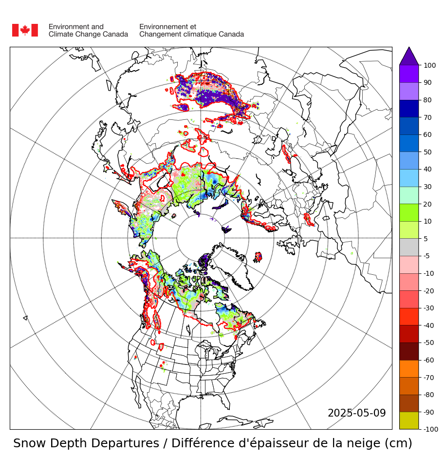
https://weather.gc.ca/saisons/animation_e.html?id=month&bc=seaIt seems both the Canadian and SE Siberian snowfall anomalies could also be partly to blame on the blazing oceanic SSTs to their SE. The Gulf Stream has shifted substantially north, and its waters now encroach directly onto southern Nova Scotia. The same seems to be happening in the NE Pacific, where there is a near 100% absence in Siberian-adjacent sea ice this year, despite the blues and purples of the snowfall anomaly map.
If accumulations of oceanic heat are all that's necessary for the current anomalous increase in snowcover and are seemingly sufficient to dwarf the impact of atmospheric CO2 to date, rolling the clock forward another 5-10 years could paint an image out of the Younger Dryas. Coincidentally, it is about the same time it took for that to happen as well.
I guess we will have to revisit this topic in 2025