Derecho With 100 mph Winds Approaches Chicago As It Moves Across the Midwesthttps://amp.cnn.com/cnn/2020/08/10/weather/derecho-forecast-chicago-severe-storms/index.htmlA line of severe storms on Monday approached downtown Chicago, where a severe thunderstorm warning was in effect.
The storms have produced winds as high as 100 mph as they moved through Iowa and Illinois.
The storms are part of what the National Weather Service's Storm Prediction Center called a "particularly dangerous situation."
Tornado warnings are in effect west of Chicago.
More than 500,000 homes and businesses in the Midwest are without power, including a third of all of customers in Iowa.
The storms are part of a derecho that was moving out of Iowa into northern Illinois, toward Chicago, and that prompted the Storm Prediction Center to issue a PDS thunderstorm watch through 7 p.m. CT Monday.

...THIS IS A PARTICULARLY DANGEROUS SITUATION...
* Primary threats include...
- Widespread damaging winds and scattered significant gusts to 100 mph likely
- Isolated large hail events to 1.5 inches in diameter possible
- A couple tornadoes possible
SUMMARY...A derecho will rapidly progress across eastern Iowa and northern Illinois this afternoon. Widespread severe wind gusts, some of which should reach 80-100 mph are anticipated along the track of the bow. Brief tornadoes are also possible.
The severe thunderstorm watch area is approximately along and 85 statute miles north and south of a line from 20 miles west southwest of Cedar Rapids IA to 75 miles south southeast of Racine WI. For a complete depiction of the watch see the associated watch outline update (WOUS64 KWNS WOU6)
https://www.spc.noaa.gov/products/watch/ww0426.html------------------------------
Destructive Derecho Blasts Chicago With Winds Over 70 mph; More Than 1 Million Lose Power In Upper Midwesthttps://www.washingtonpost.com/weather/2020/08/10/damaging-derecho-takes-aim-chicago-area-with-dangerous-winds-up-100-mph/https://mobile.twitter.com/weatherdak/status/1292944227685371905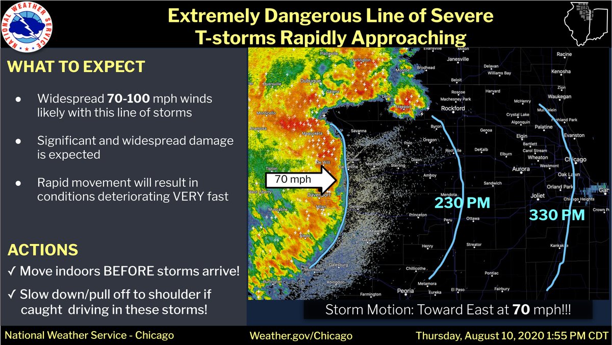
By Monday evening, more than 1 million people were without power in the wake of the storms from eastern Nebraska to northern Illinois as the storms raced eastward into southern Michigan. The storms also crossed Indiana, causing wind damage there, and moved into Ohio near 8 p.m. ET.
Iowa was hardest hit. Several locations clocked wind gusts exceeding 112 mph, while gusts between 75 and 85 mph were common, tearing apart metal silos like a sheet of paper. The storm’s intensity marginally waned as it headed east, but Chicago’s Midway Airport clocked a gust to 73 mph.

As of 8 p.m., Doppler radar indicated that the most intense winds in the derecho had passed Fort Wayne, Ind., and were pushing into northwestern Ohio. Severe weather associated with the same line of thunderstorms extended southwest to St. Louis, Mo., and north into Michigan.
https://twitter.com/bill_line/status/1292897459622928384Satellite imagery of the impending derecho was revealing on Monday afternoon. Overshooting tops could be seen as bubbles in the overcast along the eastern limb of the cloud mass where intense thunderstorm updrafts lurk. Rippling outward from them were gravity waves, akin to wavelets in a pond, indicating extreme turbulence nearby.
Particularly impressive were the tendril-like high clouds and transverse banding within it — appearing as strips of shading radially outward from the center — illustrating healthy outflow, or storm exhaust, at the upper levels. That’s a common feature on satellite associated with strong hurricanes.
... On the eastern shores of Lake Michigan in southwest Michigan, the derecho was predicted to generate large waves and push high water ashore, prompting a lakeshore flood warning.
https://mobile.twitter.com/nbcchicago/status/1292932371679973383 Numerous reports of significant winds, and at times extreme winds, have been received from across the Corn Belt:
112 mph near Midway, Iowa
106 mph near La Grand, Iowa, measured by personal weather station
100 mph near Hiawatha, Iowa
99 mph at Marshalltown Municipal Airport
99 mph near Albion, Iowa
95 mph estimated near Marshalltown, Iowa
91 mph near Marshalltown, Iowa
90 mph in Atkins, Iowa
90 mph in Blairstown, Iowa
86 mph in Davenport, Iowa
85 mph in Moline, Ill.
78 mph at Ankeny Airport
75 mph at Des Moines airport
72 mph at Midway Airport in ChicagoIn Iowa, gusts above 80 mph were ubiquitous with the line of destructive storms.
In Cedar Rapids, Iowa, an eyewitness on social media described “utter destruction.” The Iowa Department of Transportation reported that Interstate 35 and other roads were blocked due to overturned vehicles and storm damage between Cedar Rapids and Iowa City.
https://twitter.com/grabermike/status/1292884786130964481https://mobile.twitter.com/ashoward1/status/1292938287296974856https://mobile.twitter.com/WxKanost/status/1292908577162776577


