Support the Arctic Sea Ice Forum and Blog

Author Topic: Weird Weather and anecdotal stories about climate change  (Read 1220253 times)

vox_mundi

  • Multi-year ice
  • Posts: 10465
    • View Profile
  • Liked: 3535
  • Likes Given: 761
Re: Weird Weather and anecdotal stories about climate change
« Reply #3800 on: May 17, 2024, 01:13:22 PM »
Storms of My Grandchildren? ...

At Least 4 Dead in Houston as Destructive Storms Lash Texas and Louisiana With Strong Winds and Flood Threats
https://amp.cnn.com/cnn/2024/05/16/weather/south-flooding-texas-louisiana-climate
https://weather.com/news/weather/news/2024-05-16-houston-severe-weather-tornado-rain


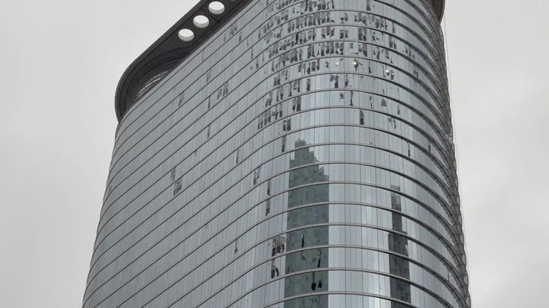
At least four people are dead in Houston after hurricane-force winds and torrential rains tore a damaging path through the city Thursday – part of a lashing storm system that is bringing life-threatening flooding and power outages to parts of the South.

Severe storms carved through parts of Texas Thursday before pushing into western Louisiana through Friday’s early hours, prompting an overnight flash flood warning for New Orleans.

... Violent storms in Houston blew out skyscraper windows, partially collapsed a nightclub and ripped a strip of roofing off the downtown Hyatt Regency, showering the hotel lobby with rain and debris, according to witness video.

"Widespread debris, glass and electrical lines are in the streets," the NWS warned.

https://x.com/NWSHouston/status/1791301992167723191

All non-essential workers are urged to stay home tomorrow and city schools are closed as widespread power outages have darkened the city and disabled traffic lights, Mayor John Whitmire said. Streets are littered with debris, downed trees and power lines, and the downtown area is dusted with glass from broken windows, he added.

Winds in the city were reported as high as 71 mph, according to the weather service. On the east side of the city, there were reports of winds up to 78 mph – equivalent to the strength of a Category 1 hurricane.


The weather service also reported straight-line winds of up to 100 mph (161 kph) in downtown Houston and the suburbs of Baytown and Galena Park.

There were wind gusts of 84 mph (135 kph) at Louis Armstrong New Orleans International Airport and 82 mph (132 kph) at New Orleans Lakefront Airport, according to Tim Erickson, a meteorologist at the weather service’s office for New Orleans and Baton Rouge

... Power outages left more than 1,000,000 homes and businesses in the dark across Texas as of Thursday night. More than 200,000 are also without power in Louisiana as storms batter the state.

Possible tornadoes posed a risk in Texas and Louisiana, and carried the threat of destructive winds and golf ball-sized hail. A reported tornado in Convent, Louisiana, downed trees and power poles late Thursday, the Storm Prediction Center said.

Parts of Texas and western Louisiana are under a rare Level 4 of 4 high risk of excessive rainfall Thursday, the Weather Prediction Center said. More than 600,000 people live in the high-risk zone.

... Widespread rainfall totals of 2 to 6 inches are expected from Texas to Georgia through Saturday morning. A few spots caught under multiple torrential storms may pick up 8 inches or more of rain. It’s not out of the question that one or two spots could record close to a foot of rain in about 48 hours.

Texas and Louisiana have been in the bull’s-eye of seemingly unrelenting rounds of torrential, flooding downpours since the start of April. Rainfall in the waterlogged area over the last two weeks is over 600% of what’s typical, according to the WPC.

The weather service also issued a severe thunderstorm warning for Houston with the highest-level “destructive” tag.


Double-digit rainfall totals between 20 and 30 inches over the region in recent weeks have soaked the ground and left rivers swollen, priming the flood threat to extreme levels.

Drenched soils are not expected to soak up any of Thursday’s rainfall, the WPC warned Thursday morning. Widespread flash flooding could begin minutes after heavy rain starts to fall.

It’s a sign the atmosphere is primed to unload extreme amounts of rain, a phenomenon that is becoming more frequent in a warming world driven by human-caused climate change.

--------------------------------------------------------

Harris County residents ‘may have to go a couple of weeks without power’ after severe weather rips through SE Texas
https://www.click2houston.com/news/local/2024/05/17/harris-county-judge-lina-hidalgo-provides-latest-updates-on-deadly-severe-weather-that-ripped-through-se-texas/

While daylight revealed just how intense the storms were, Harris County Judge Lina Hidalgo and Houston Mayor John Whitmire both addressed community members Friday morning.

Hidalgo said its been a long two weeks for the Houston area and this is the second storm that has battered the area within those weeks. Local officials expected some rain but instead experienced 85 mph to 100 mph wind damage.

The county judge compared Thursday’s weather scenario to Hurricane Alicia in 1983.

There has been four weather-related casualties, damaged roads, flipped 18-wheelers, structural fires, downed trees and power lines. Recovery efforts are underway as crews work to clear freeways and roadways.

Mayor Whitmire said at least 2,500 traffic lights are not functioning and crews are also working to fix.

The county judge says residents “may have to go a couple of weeks without power” who are tied to the 10 transmission lines that fell during the storm. Seven out of the 10 damaged transmissions are in Harris County.
« Last Edit: May 18, 2024, 12:01:17 AM by vox_mundi »
There are 3 classes of people: those who see. Those who see when they are shown. Those who do not see

Insensible before the wave so soon released by callous fate. Affected most, they understand the least, and understanding, when it comes, invariably arrives too late

Fiat iustitia, et pereat mundus

vox_mundi

  • Multi-year ice
  • Posts: 10465
    • View Profile
  • Liked: 3535
  • Likes Given: 761
Re: Weird Weather and anecdotal stories about climate change
« Reply #3801 on: May 19, 2024, 12:07:00 AM »
Hot Weather Poses New Risk As Thousands Remain Without Power After Deadly Houston Storm
https://apnews.com/article/houston-texas-storms-power-outages-86643a6d7decd28e971774e03b52e51d

HOUSTON (AP) — As the Houston area works to clean up and restore power to hundreds of thousands after deadly storms left at least seven people dead, it will do so amid a smog warning and scorching temperatures that could pose health risks.

National Weather Service meteorologist Marc Chenard said on Saturday that highs of around 90 degrees (32.2 C) were expected through the start of the coming week, with heat indexes likely approaching 100 degrees (38 C) by midweek.

“We expect the impact of the heat to gradually increase ... we will start to see that heat risk increase Tuesday into Wednesday through Friday,” Chenard said.

In addition to the heat, the Houston area could face poor air quality during the weekend.

... More than a half-million homes and businesses in Texas remained without electricity by midday Saturday
, according to PowerOutage.us. Another 21,000 customers were also without power in Louisiana, where strong winds and a suspected tornado hit.
There are 3 classes of people: those who see. Those who see when they are shown. Those who do not see

Insensible before the wave so soon released by callous fate. Affected most, they understand the least, and understanding, when it comes, invariably arrives too late

Fiat iustitia, et pereat mundus

vox_mundi

  • Multi-year ice
  • Posts: 10465
    • View Profile
  • Liked: 3535
  • Likes Given: 761
Re: Weird Weather and anecdotal stories about climate change
« Reply #3802 on: June 06, 2024, 02:10:25 PM »
Hail Stone the Size of a Pineapple Found In Texas. Likely Sets a State Record
https://phys.org/news/2024-06-hail-stone-size-pineapple-texas.html


Val and Amy Castor, veteran storm chasers with Oklahoma City television station KWTV, discovered a piece of hail more than 7 inches (17.78 centimeters) long Sunday along the side of the road near Vigo Park while they were chasing a major thunderstorm system.

Val Castor said the stone was about the size of a pineapple.

"That's the biggest hail I've ever seen, and I've been chasing storms for more than 30 years," Castor said.


Castor said several baseball-sized hail stones fell while he was driving, including one that cracked his windshield, before he spotted the big piece in a ditch on the side of the road.

"I could see it from probably 100 yards away," he said.

The massive hail stone is believed to be a new state record, topping a 6.4-inch (16.25-centimeter) hail stone found in Hondo in 2021.

The heaviest hail stone on record in the United States had a reported diameter of 11 inches (27.94 centimeters) and weighed nearly 2 pounds (907 grams). It was discovered near Vivian, South Dakota, in July 2010, according to the National Centers for Environmental Information.
There are 3 classes of people: those who see. Those who see when they are shown. Those who do not see

Insensible before the wave so soon released by callous fate. Affected most, they understand the least, and understanding, when it comes, invariably arrives too late

Fiat iustitia, et pereat mundus

vox_mundi

  • Multi-year ice
  • Posts: 10465
    • View Profile
  • Liked: 3535
  • Likes Given: 761
Re: Weird Weather and anecdotal stories about climate change
« Reply #3803 on: June 12, 2024, 06:43:23 PM »
Southern Florida Receives Record Rainfall and Flash Flooding In a 500-to-1,000-Year Event
https://www.nbcnews.com/news/us-news/southern-florida-receives-record-rainfall-flash-flooding-500-1000-year-rcna156700

The 3.93 inches (100 mm) of rain that fell at the Sarasota-Bradenton Airport in one hour is also a record — and more rain is expected this week.

A city on Florida's west coast was hit by a record-breaking 8 inches of rain in just three hours on Tuesday evening, bringing flash floods to the area, hindering drivers and delaying hundreds of flights across the state.

So rare was Tuesday's rain between 5 p.m. and 8 p.m. in Sarasota that it should only be expected every 500 to 1,000 years. The Tampa Bay area can normally expect 7.3 inches in the entire month of June.

Coastal areas in Sarasota County saw up to 10 inches of rain on Tuesday alone, with the same possible Wednesday and throughout the week, the NWS office in Tampa Bay said.

https://x.com/NWSTampaBay/status/1800828574758527204


Video uploaded to social media showed a fire truck and lanes of traffic driving badly flooded roads in Sarasota. Across the region cars became stranded after attempting to drive through deep water, including in Siesta Key to the west of Sarasota.

Video: https://x.com/zpski/status/1800721901557612603

Video: https://x.com/SceneFirst1/status/1800718773596590164

https://x.com/ryantnt/status/1800693019508891979

The weather system was caused by deep tropical moisture from a disturbance called 90-L by the National Hurricane Center, as well as a small area of low pressure of Florida's west coast and "a very slow-moving stubborn convergent band," according to Jeff Berardelli, chief meteorologist at NBC affiliate WFLA of Tampa.

More rain is expected throughout this week across the state. The National Weather Service warned residents to expect more than 7 inches of rain in "a prolonged heavy to excessive rainfall event across southern Florida for the next several days," in a forecast early Wednesday.


https://www.wpc.ncep.noaa.gov/metwatch/metwatch_mpd_multi.php?md=0427&yr=2024

Summary...Localized rainfall rates on the order of 2-4"/hr may support additional localized totals of 6"+ with sufficient training/repeating of cells. Localized instances of flash flooding are likely, given the increased sensitivity from recent heavy rainfall.

Discussion...Heavy shower activity is once again building over the warm waters of the southeast Gulf of Mexico, following a relative lull this morning in convective activity along the western coast of central FL. A 25-35 kt low-level jet (LLJ) is situated just downstream (with the maxima near the eastern central coast of FL), resulting in a localized enhancement of lift (via DPVA with minimal influence from upper-level dynamics). The mesoscale environment is reminiscent of the tropics, as PWATs of 2.0-2.5" are near record levels (per TBW sounding climatology) with dew points in the upper 70s to near 80deg F, ML CAPE of 1000-1500 J/kg, and effective bulk shear near 20 kts. While deep convection may be able to tap into more significant instability (as indicated by 3000-5000 MU CAPE just offshore), relatively shallow heavy showers/thunderstorms will easily produce 1-2"/hr rates (with more intense convection capable of 2-4"/hr rates, particularly if additional training/repeating occurs).

Hi-res CAMs paint a rather concerning picture this morning, suggesting additional localized totals of 6"+ are possible through 18z. This is indicated by both the 06z HREF probability matched mean (PMM) QPF and 40-km neighborhood exceedance probabilities (40-70% for 5" exceedance), as well as by hourly runs of the HRRR since 06z. That said, not every HREF member or every run of the HRRR indicates such totals, as this threat is conditionally dependent on a training/repeating axis to set up along the coast. This could occur anywhere from Sarasota to Naples, though the Fort Myers/Punta Gorda region looks most favored (per the observational trends matching up quite well with guidance). Given that average totals over the past 24 hours commonly range from 3-5" (with localized totals remarkably as high as 6-12", per MRMS estimates), isolated instances of flash flooding appear to be likely (with locally significant impacts possible in poor drainage, urbanized terrain).

There are 3 classes of people: those who see. Those who see when they are shown. Those who do not see

Insensible before the wave so soon released by callous fate. Affected most, they understand the least, and understanding, when it comes, invariably arrives too late

Fiat iustitia, et pereat mundus

vox_mundi

  • Multi-year ice
  • Posts: 10465
    • View Profile
  • Liked: 3535
  • Likes Given: 761
Re: Weird Weather and anecdotal stories about climate change
« Reply #3804 on: June 13, 2024, 07:57:47 PM »
State of 'Catastrophe' As Downpours Hit Chile
https://phys.org/news/2024-06-state-catastrophe-downpours-chile.html


Heavy rains battered south and central Chile on Thursday, killing one person and causing damage to hundreds of homes as authorities declared a state of catastrophe in five regions of the South American country.

Chile's weather service issued the highest level of alarm, covering some 14 million of the 20 million people living in five of the country's 16 regions.

Prior to the arrival of the flood waters, the country's central region had battled severe drought for 15 years.

Curanilahue, some 600 kilometers (372 miles) south of the capital Santiago, has been hard hit as the Curanilahue and Las Ranas rivers overflowed after the area received 350 millimeters (13.7 inches) of rain in just hours—more than in 2023 as a whole.

Schools in the capital and other regions were closed, and the authorities urged people to limit their movements.

In the city of Vina del Mar, a 12-story apartment building is at risk of collapse after the rains caused a massive sink hole underneath it.

The weather service said a cold front over the country was accompanied by something called an "atmospheric river"—a strip of air carrying huge amounts of moisture.
There are 3 classes of people: those who see. Those who see when they are shown. Those who do not see

Insensible before the wave so soon released by callous fate. Affected most, they understand the least, and understanding, when it comes, invariably arrives too late

Fiat iustitia, et pereat mundus