The 2000Z NWS 168h QPF (7 day quantitative precipitation forecast) just out does not paint a good picture:
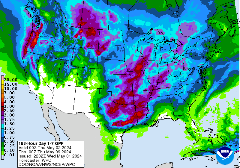
The 14.5" bullseye and the 10-15" contour are lined up right over the Lake Oroville / Upper Feather drainage. This actually looks worse than the setup that led to the overtopping of the emergency spillway last week:

Slightly lower snow levels will likely moderate some of the impact, unless the later storms come in warm and melt the newly-fallen marginal/low-elevation snow.
In terms of hydrologic state now versus at the start of the precipitation that led to the overflow event:
-Inflows are about the same (~20kcfs)
-There is less than half the storage available: (24' / 352000af vs. 52' / 738000af)
-Releases are more constrained by the state of rest of the flood control system (Shasta Dam level/releases/etc)
-The powerplant discharge capacity is not available
In terms of structural stability - the Oroville Dam section of this document:
http://www.archive.org/stream/zh9californiastatew2003calirich/zh9californiastatew2003calirich_djvu.txt is as good a source as I've found online regarding the design and construction of the spillway facilities.
Two items in stood out to me:
-The original design called for an unlined primary/flood-control spillway in the same channel as the current lined channel, but the bedrock was found to be unsuitable due to the amount of eroded material that would be washed into the outflow pool, potentially interfering with power plant operations as has happened during this event
-While the bedrock in the spillway area is mostly quite resistant, there are multiple shear zones steeply dipping and striking roughly normal to the plane of the dam. These zones are extensively weathered from the surface to depths of at least 100'. This could account for the extremely rapid erosion into bedrock in the channels just below the emergency spillway. Headwall cutting of these channels could easily lead to undermining of the emergency spillway, which sits on top of a grout curtain but not on a structural foundation.
Failure of the dam embankment itself seems very far-fetched (well-nigh impossible, in fact), but a problem in the emergency spillway weir coupled with erosion of 10s-100s of feet into weathered bedrock could lead to loss of control over the top 30-100 feet of the pool, which would be an enormous problem during the initial outflow and during runoff management during this extremely snowy and wet season.


