Antarctic Lake Suddenly Disappearshttps://phys.org/news/2021-06-antarctic-lake-suddenly.html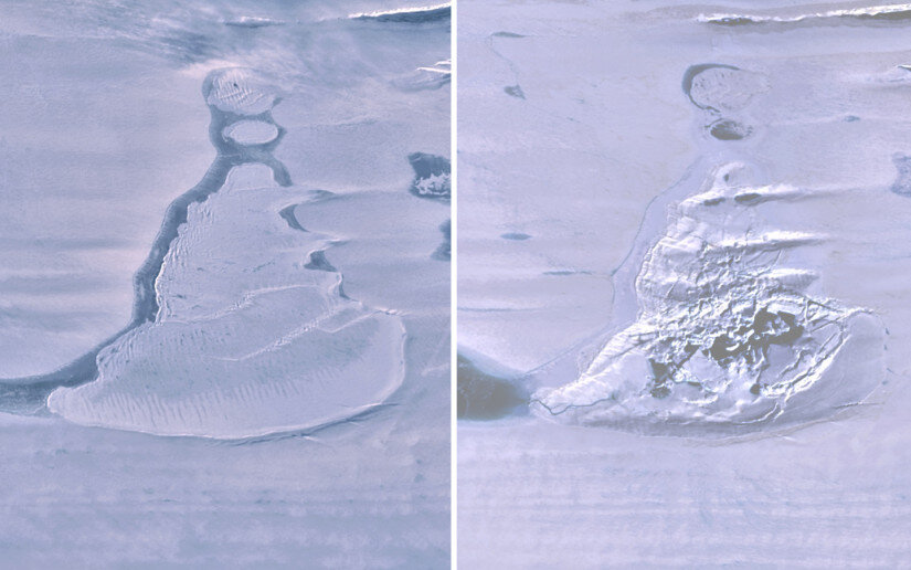
A global team of scientists including several from Scripps Institution of Oceanography at the University of California San Diego discovered the sudden demise of a large, deep, ice-covered lake on the surface of an Antarctic ice shelf.
This rare event, chronicled in a study published today in the journal
Geophysical Research Letters, occurred during the 2019 Antarctic winter on
Amery Ice Shelf in East Antarctica, and
it is estimated that 600-750 million cubic meters (21-26 billion cubic feet) of water, about twice the volume of San Diego Bay, were lost to the ocean.Study authors used images from a radar satellite which can "see" during the polar night to pin the event's timing down to a week or less in June. After drainage, in place of the lake, there was a crater-like depression in the ice shelf surface, covering about
eleven square kilometers (4.25 square miles). This surface depression, known as an ice "
doline," contained the fractured remains of the ice cover.
The
hydrofracture process has been implicated in the collapse of smaller ice shelves in the Antarctic Peninsula, where meltwater forms on the surface of ice shelves during austral summer, but
it is not often seen driving through ice as thick as the 1400 meters (4,590 feet) at this location on Amery Ice Shelf.
Repeat orbits of ICESat-2 on the exact ground tracks before and after the lake drainage revealed the vertical scale of the disruption.
The ice surface fell as much as 80 meters (260 feet) in the doline cavity, even though the loss of the water load made the floating ice shelf lighter and ocean pressure caused it to flex upwards, with the lake's immediate surroundings rising as much as 36 meters (118 feet).The team also used surface elevation maps generated by the Polar Geospatial Center (PGC) at the University of Minnesota to show that the disruption modified the regional landscape across 60 square kilometers (23 square miles).
The uplift of the lake created a new lake out of a shallow arm of the original one. During the next melt season this lake filled within a few days at more than a million cubic meters per day and overflowed into the doline cavity. When ICESat-2 crossed the doline again a few days later, the team was able to measure a meltwater channel 20 meters (65 feet) wide, freshly cut into the doline, detecting the water surface at three meters depth, and photons scattered from the stream bed a further three meters below.
The amount of water lost to the ocean was calculated using the volume of the cavity and the extent of uplift. While Amery Ice Shelf does have many melt-lakes and streams in austral summer, the amount of water lost when the lake drained was many times the annual meltwater input to it.
"This abrupt event was apparently the culmination of decades of melt-water accumulation and storage beneath that insulating lid of ice," said co-author Jonathan Kingslake, professor at Lamont Doherty Earth Observatory at Columbia University, who aided in the measuring of the surface meltwater.
The future of the newly formed doline is uncertain. It may accumulate meltwater again or drain to the ocean more frequently. It appears that the fissure reopened briefly in the 2020 melt season. It is certain that scientists will now be watching.
Roland C. Warner et al,
Rapid formation of an ice doline on Amery Ice Shelf, East Antarctica,
Geophysical Research Letters (2021).
https://agupubs.onlinelibrary.wiley.com/doi/10.1029/2020GL091095


