Support the Arctic Sea Ice Forum and Blog

Author Topic: 2021 ENSO  (Read 7956 times)

gerontocrat

  • Multi-year ice
  • Posts: 20612
    • View Profile
  • Liked: 5308
  • Likes Given: 69
2021 ENSO
« on: February 11, 2021, 03:39:26 PM »
late on parade starting this new topic.

https://www.cpc.ncep.noaa.gov/products/analysis_monitoring/enso_advisory/ensodisc.shtml
Quote
EL NIÑO/SOUTHERN OSCILLATION (ENSO)
DIAGNOSTIC DISCUSSION
issued by
CLIMATE PREDICTION CENTER/NCEP/NWS
and the International Research Institute for Climate and Society
11 February 2021
 
ENSO Alert System Status: La Niña Advisory

Synopsis:  There is a ~60% chance of a transition from La Niña to ENSO-Neutral during the Northern Hemisphere spring 2021 (April-June).

La Niña persisted in January, reflected by below-average sea surface temperatures (SST) anomalies extending from the western to east-central Pacific Ocean [Fig. 1]. SSTs returned to near average in the eastern Pacific Ocean by the end of the month, as indicated by the latest weekly Niño-3 and Niño-1+2 index values of -0.3°C and -0.2°C, respectively [Fig. 2]. However, the latest weekly Niño index values in the central (Niño-4) and east-central (Niño-3.4) Pacific Ocean were -1.1°C and -0.7°C. The below-average SSTs were supported by negative subsurface temperature anomalies [Fig. 3], which extended from the surface to at least ~150m below the surface between 160°E and 130°W [Fig. 4]. Low-level wind anomalies remained easterly from the western to east-central (~140°W) tropical Pacific, with the largest amplitude near the Date Line. Upper-level wind anomalies were westerly across most of the tropical Pacific. Tropical convection continued to be suppressed over the western and central Pacific and enhanced around the Philippines and Indonesia [Fig. 5], while both the Southern Oscillation and Equatorial Southern Oscillation remained positive. Overall, the coupled ocean-atmosphere system remains consistent with La Niña.

Most of the models in the IRI/CPC plume predict a transition to ENSO-neutral during the Northern Hemisphere spring 2021 [Fig. 6]. The forecaster consensus is in agreement with this transition and then predicts a continuation of ENSO-neutral at least through the Northern Hemisphere summer. In part, due to the inherent uncertainty in predictions made at this time of year, the forecast for the fall remains split (~50%) between La Niña and the combination of the other two possibilities (El Niño and Neutral). In summary, there is a ~60% chance of a transition from La Niña to ENSO-Neutral during the Northern Hemisphere spring 2021 (April-June; click CPC/IRI consensus forecast for the chances in each 3-month period).

La Niña is anticipated to affect climate across the United States during the upcoming months. The 3-month seasonal temperature and precipitation outlooks will be updated on Thursday February 18th.

This discussion is a consolidated effort of the National Oceanic and Atmospheric Administration (NOAA), NOAA's National Weather Service, and their funded institutions. Oceanic and atmospheric conditions are updated weekly on the Climate Prediction Center web site (El Niño/La Niña Current Conditions and Expert Discussions). Additional perspectives and analysis are also available in an ENSO blog. A probabilistic strength forecast is available here. The next ENSO Diagnostics Discussion is scheduled for 11 March 2021.

To receive an e-mail notification when the monthly ENSO Diagnostic Discussions are released, please send an e-mail message to: ncep.list.enso-update@noaa.gov.

 
Climate Prediction Center
5830 University Research Court
College Park, Maryland 20740[/size]
"Para a Causa do Povo a Luta Continua!"
"And that's all I'm going to say about that". Forrest Gump
"Damn, I wanted to see what happened next" (Epitaph)

Tom_Mazanec

  • Guest
Re: 2021 ENSO
« Reply #1 on: February 11, 2021, 05:16:18 PM »
So at least one forecast gives a moderate El Nino by summer?

Rodius

  • Nilas ice
  • Posts: 2179
    • View Profile
  • Liked: 651
  • Likes Given: 46
Re: 2021 ENSO
« Reply #2 on: February 12, 2021, 03:56:27 AM »
I wish there were more La Nina events, the weather in Melbourne this summer has excluded heatwave and extra heat. It has been great summer..... shame it wont happen next summer and I dread the next El Nino.

grixm

  • Grease ice
  • Posts: 700
    • View Profile
  • Liked: 374
  • Likes Given: 131
Re: 2021 ENSO
« Reply #3 on: March 09, 2021, 11:03:46 PM »
Niño 3.4 jumped a bit last week and is now warmer than it has been for quite a while.


gerontocrat

  • Multi-year ice
  • Posts: 20612
    • View Profile
  • Liked: 5308
  • Likes Given: 69
Re: 2021 ENSO
« Reply #4 on: March 11, 2021, 03:16:48 PM »
Quote
EL NIÑO/SOUTHERN OSCILLATION (ENSO)
DIAGNOSTIC DISCUSSION
issued by
CLIMATE PREDICTION CENTER/NCEP/NWS
and the International Research Institute for Climate and Society
11 March 2021

ENSO Alert System Status: La Niña Advisory

 
Synopsis:  There is a ~60% chance of a transition from La Niña to ENSO-Neutral during the Northern Hemisphere spring 2021 (April-June).

La Niña continued during February, reflected by below-average sea surface temperatures (SST) anomalies, which extended from the western to east-central Pacific Ocean [Fig. 1]. SSTs returned to near average in the eastern Pacific Ocean by late January, before oscillating during February, as indicated by the week-to-week variability in most of the Niño index regions [Fig. 2]. The latest weekly Niño index values in the central (Niño-4) and east-central (Niño-3.4) Pacific Ocean were -0.8°C and -0.7°C. The below-average SSTs were linked to negative subsurface temperature anomalies [Fig. 3], which weakened noticeably during the month. Currently, negative subsurface anomalies extended from the surface to approximately ~150m below the surface between 150°E and 90°W [Fig. 4]. Low-level wind anomalies showed periods of enhanced, but localized, easterlies in the east-central Pacific. Upper-level wind anomalies were westerly across the central and eastern tropical Pacific. The suppression of tropical convection over the western and central Pacific weakened during February, as did the enhancement of rainfall around the Philippines and Indonesia [Fig. 5] compared to the previous few months. The Southern Oscillation and Equatorial Southern Oscillation remained positive, but also weakened. Overall, the coupled ocean-atmosphere system is consistent with a weak or decaying La Niña.

Most of the models in the IRI/CPC plume predict a transition to ENSO-neutral during the Northern Hemisphere spring 2021 [Fig. 6]. The forecaster consensus agrees with this transition and then predicts a continuation of ENSO-neutral at least through the Northern Hemisphere summer. In part, due to the uncertainty in predictions made at this time of year, the forecast for September-November remains lower confidence with a 45-50% for La Niña and 40-45% for ENSO-Neutral, with a low chance for El Niño. In summary, there is a ~60% chance of a transition from La Niña to ENSO-Neutral during the Northern Hemisphere spring 2021 (April-June; click CPC/IRI consensus forecast for the chances in each 3-month period).

La Niña is anticipated to affect climate across the United States during the upcoming months. The 3-month seasonal temperature and precipitation outlooks will be updated on Thursday March 18th.

This discussion is a consolidated effort of the National Oceanic and Atmospheric Administration (NOAA), NOAA's National Weather Service, and their funded institutions. Oceanic and atmospheric conditions are updated weekly on the Climate Prediction Center web site (El Niño/La Niña Current Conditions and Expert Discussions). Additional perspectives and analysis are also available in an ENSO blog. A probabilistic strength forecast is available here. The next ENSO Diagnostics Discussion is scheduled for 8 April 2021.

To receive an e-mail notification when the monthly ENSO Diagnostic Discussions are released, please send an e-mail message to: ncep.list.enso-update@noaa.gov.

 
Climate Prediction Center
5830 University Research Court
College Park, Maryland 20740[/size]

click images to enlarge
"Para a Causa do Povo a Luta Continua!"
"And that's all I'm going to say about that". Forrest Gump
"Damn, I wanted to see what happened next" (Epitaph)

grixm

  • Grease ice
  • Posts: 700
    • View Profile
  • Liked: 374
  • Likes Given: 131
Re: 2021 ENSO
« Reply #5 on: March 28, 2021, 10:31:06 AM »
Daily values have now been in the ENSO Neutral range for over three weeks.

(This doesn't mean we don't still have La Niña, but it's likely the beginning of the end.)

Jim Hunt

  • First-year ice
  • Posts: 6270
  • Don't Vote NatC or PopCon, Save Lives!
    • View Profile
    • The Arctic sea ice Great White Con
  • Liked: 894
  • Likes Given: 87
Re: 2021 ENSO
« Reply #6 on: March 30, 2021, 05:09:33 PM »
(This doesn't mean we don't still have La Niña, but it's likely the beginning of the end.)

According to today's BoM ENSO outlook:

Quote
The 2020−21 La Niña has ended, having been active since September 2020. The tropical Pacific Ocean has returned to near-normal temperatures, in line with the typical El Niño / La Niña life-cycle. Most model outlooks suggest a neutral El Niño-Southern Oscillation (ENSO) state (neither El Niño nor La Niña) is the most likely scenario through the remainder of the southern hemisphere autumn and winter.
"The most revolutionary thing one can do always is to proclaim loudly what is happening" - Rosa Luxemburg

gerontocrat

  • Multi-year ice
  • Posts: 20612
    • View Profile
  • Liked: 5308
  • Likes Given: 69
Re: 2021 ENSO
« Reply #7 on: April 09, 2021, 10:03:00 AM »
Quote
EL NIÑO/SOUTHERN OSCILLATION (ENSO)
DIAGNOSTIC DISCUSSION
issued by
CLIMATE PREDICTION CENTER/NCEP/NWS
and the International Research Institute for Climate and Society
8 April 2021
 
ENSO Alert System Status: La Niña Advisory

 
Synopsis:  A transition from La Niña to ENSO-Neutral is likely in the next month or so, with an 80% chance of ENSO-neutral during May-July 2021.

La Niña continued during March, reflected by negative sea surface temperatures (SST) anomalies, which extended across much of the equatorial Pacific Ocean [Fig. 1]. SST anomalies weakened but continue to oscillate week-to-week in most of the Niño index regions, particularly in the eastern Pacific Ocean [Fig. 2]. Except for Niño-1+2, the latest weekly Niño index values were at or near -0.5°C. Sub-surface ocean temperatures also weakened during the month, with the integrated anomalies averaged between the 180-100°W becoming positive during the middle of the month [Fig. 3]. Currently, negative subsurface temperature anomalies are present from the surface to approximately ~100m below the surface only in the eastern Pacific between 110°W and 80°W [Fig. 4]. Low-level easterly wind anomalies are present but weak across the equatorial Pacific, and are most notable in the far western Pacific. Upper-level wind anomalies were westerly across most of the tropical Pacific. The suppression of tropical convection over the western and central Pacific persisted during March, although the enhancement of rainfall around the Philippines and Indonesia weakened [Fig. 5]. The Southern Oscillation and Equatorial Southern Oscillation were weakly positive in March. Overall, the trend in the coupled ocean-atmosphere system is consistent with a weakening La Niña.

Most of the models in the IRI/CPC plume predict a transition to ENSO-neutral during the Northern Hemisphere spring 2021 [Fig. 6]. The forecaster consensus agrees that a transition is imminent, with a 50-50% chance of La Niña or ENSO-neutral for the March-May average, and then predicts ENSO-neutral to continue at least through the Northern Hemisphere summer. In part, due to the uncertainty in predictions made at this time of year, the forecast for the Northern Hemisphere Fall 2021 has lower confidence with a 40-50% chance of either La Niña or ENSO-Neutral, with a small chance for El Niño. In summary, a transition from La Niña to ENSO-Neutral is likely in the next month or so, with an 80% chance of ENSO-neutral during May-July 2021 (click CPC/IRI consensus forecast for the chances in each 3-month period).

This discussion is a consolidated effort of the National Oceanic and Atmospheric Administration (NOAA), NOAA's National Weather Service, and their funded institutions. Oceanic and atmospheric conditions are updated weekly on the Climate Prediction Center web site (El Niño/La Niña Current Conditions and Expert Discussions). Additional perspectives and analysis are also available in an ENSO blog. A probabilistic strength forecast is available here. The next ENSO Diagnostics Discussion is scheduled for 13 May 2021.

To receive an e-mail notification when the monthly ENSO Diagnostic Discussions are released, please send an e-mail message to: ncep.list.enso-update@noaa.gov.

 
Climate Prediction Center
5830 University Research Court
College Park, Maryland 20740
[/size]
"Para a Causa do Povo a Luta Continua!"
"And that's all I'm going to say about that". Forrest Gump
"Damn, I wanted to see what happened next" (Epitaph)

vox_mundi

  • Multi-year ice
  • Posts: 10238
    • View Profile
  • Liked: 3519
  • Likes Given: 755
Re: 2021 ENSO
« Reply #8 on: April 15, 2021, 06:44:59 PM »
Scientists More Confident Projecting ENSO Changes Under Global Warming
https://phys.org/news/2021-04-scientists-confident-enso-global.html

An international team of scientists from the Institute of Atmospheric Physics (IAP) of the Chinese Academy of Sciences, the University of Tokyo, and the University of California, San Diego reported that ENSO-related climate variability seems doomed to increase under global warming. Their findings were published in Nature Geoscience on April 15.

Recently, the climate science community has found that ENSO's changes in fact strictly obey some basic physical mechanisms, which can reduce uncertainty in ENSO projections under greenhouse warming. "The saturation vapor pressure increases exponentially with the increase of temperature, so the same air temperature anomaly will lead to a larger saturation vapor pressure anomaly in a warmer climate," said lead author Dr. Hu Kaiming from IAP. "As a result, under global warming, even if ENSO's sea surface temperature remains unchanged, the response of tropical lower tropospheric humidity to ENSO will amplify, which in turn results in major reorganization of atmospheric temperature, circulation and rainfall."

Based on this mechanism, the team deduced an intensification in ENSO-driven anomalies in tropical humidity, tropical rainfall, upper tropospheric temperature in the tropics, and the subtropical jets under global warming. Almost all the latest CMIP5/6 climate model projections agreed well with the theoretical deduction, indicating the mechanism and projections were robust. "As extreme weather often results from ENSO-induced anomalous atmospheric circulation and temperature, the intensification of ENSO-driven atmospheric variability suggests that the risk of extreme weather will increase in the future," said Dr. Hu.


Intensification of El Niño-induced atmospheric anomalies under greenhouse warming, Nature Geoscience (2021)
https://www.nature.com/articles/s41561-021-00730-3
“There are three classes of people: those who see. Those who see when they are shown. Those who do not see.” ― anonymous

Insensible before the wave so soon released by callous fate. Affected most, they understand the least, and understanding, when it comes, invariably arrives too late

Gray-Wolf

  • Grease ice
  • Posts: 948
    • View Profile
  • Liked: 131
  • Likes Given: 461
Re: 2021 ENSO
« Reply #9 on: April 23, 2021, 02:08:40 PM »
I remember when it was only deep within climate forums that such things as below could be discussed......now it's NOAA blog posts.......


https://www.climate.gov/news-features/blogs/enso/enso-running-fever-or-it-global-warming
KOYAANISQATSI

ko.yaa.nis.katsi (from the Hopi language), n. 1. crazy life. 2. life in turmoil. 3. life disintegrating. 4. life out of balance. 5. a state of life that calls for another way of living.
 
VIRESCIT VULNERE VIRTUS

The Walrus

  • Young ice
  • Posts: 2880
    • View Profile
  • Liked: 150
  • Likes Given: 488
Re: 2021 ENSO
« Reply #10 on: May 05, 2021, 10:12:07 PM »
UAH just released their monthly lower tropospheric temperatures.  The current La Nina appears to have a stronger influence than in 2018.

BeeKnees

  • Nilas ice
  • Posts: 2319
    • View Profile
  • Liked: 338
  • Likes Given: 335
Re: 2021 ENSO
« Reply #11 on: May 06, 2021, 12:24:37 AM »
Which is to be expected
The Russian State has embarked on a genocide of Ukrainians that is supported by the owner of this forum

The Walrus

  • Young ice
  • Posts: 2880
    • View Profile
  • Liked: 150
  • Likes Given: 488
Re: 2021 ENSO
« Reply #12 on: May 11, 2021, 07:40:43 PM »
La Nina has certainly affected global temperatures.  Winter 2021 was the eighth warmest, 0.4 C cooler than the record 2016.  The 10 warmest winters are in order:  2016, 2020, 2017, 2019, 2015, 2018, 2010, 2021, 2014, 2013, 2005.  With this relatively cold start to the year, it is hard to see 2021 rise past 6th warmest year on record.  Additionally, the coldest areas when further north; Alaska and Siberia, would bodes well for Arctic sea ice this year.

https://www.ncdc.noaa.gov/sotc/global/202103/supplemental/page-1

kassy

  • Moderator
  • First-year ice
  • Posts: 8333
    • View Profile
  • Liked: 2053
  • Likes Given: 1989
Re: 2021 ENSO
« Reply #13 on: May 11, 2021, 08:25:22 PM »
Not too sure about the ice because of all the other things changing but we will see.
Þetta minnismerki er til vitnis um að við vitum hvað er að gerast og hvað þarf að gera. Aðeins þú veist hvort við gerðum eitthvað.

gerontocrat

  • Multi-year ice
  • Posts: 20612
    • View Profile
  • Liked: 5308
  • Likes Given: 69
Re: 2021 ENSO
« Reply #14 on: May 13, 2021, 03:47:27 PM »
https://www.cpc.ncep.noaa.gov/products/analysis_monitoring/enso_advisory/ensodisc.shtml

Goodbye la nina, Hullo neutral

Quote
EL NIÑO/SOUTHERN OSCILLATION (ENSO)
DIAGNOSTIC DISCUSSION

issued by
CLIMATE PREDICTION CENTER/NCEP/NWS
and the International Research Institute for Climate and Society
13 May 2021
 
ENSO Alert System Status: Final La Niña Advisory

 
Synopsis:  La Niña has ended, with ENSO-neutral likely to continue through the Northern Hemisphere summer (67% chance in June-August 2021).

During April, the tropical Pacific Ocean returned to ENSO-neutral conditions as the coupling between the atmosphere and ocean weakened. Sea surface temperatures were near-to-below average across most of the equatorial Pacific Ocean in the past month [Fig. 1]. The Niño indices have generally trended toward normal during the last several months, except for the easternmost Niño-1+2 region, which was -0.7°C in the past week [Fig. 2]. Subsurface temperature anomalies continued to increase [Fig. 3] due to a downwelling Kelvin wave, which reinforced the positive temperature anomalies along the thermocline [Fig. 4]. Low-level easterly wind anomalies were weakly present in the east-central Pacific, but were westerly in the far western Pacific Ocean, while upper-level wind anomalies remained westerly across the central and east-central tropical Pacific. Tropical convection became near average around the Date Line in the past month, with suppressed convection evident over Indonesia [Fig. 5]. Overall, the ocean and atmosphere system reflected a return to ENSO-neutral.

Most of the models in the IRI/CPC plume predict a continuation of ENSO-neutral through the Northern Hemisphere summer 2021 [Fig. 6]. The forecaster consensus agrees with this set of models through the summer, and then begins hedging toward cooler conditions as the Northern Hemisphere fall approaches. La Niña chances are around 50-55% during the late fall and winter, which is in alignment with forecasts from the NCEP Climate Forecast System and North American Multi-model Ensemble. However, there is typically large uncertainty with forecasts made in the spring, so confidence in ENSO-neutral for the coming seasons is highest. In summary, La Niña has ended, with ENSO-neutral likely to continue through the Northern Hemisphere summer (67% chance in June-August 2021; click CPC/IRI consensus forecast for the chances in each 3-month period).

This discussion is a consolidated effort of the National Oceanic and Atmospheric Administration (NOAA), NOAA's National Weather Service, and their funded institutions. Oceanic and atmospheric conditions are updated weekly on the Climate Prediction Center web site (El Niño/La Niña Current Conditions and Expert Discussions). Additional perspectives and analysis are also available in an ENSO blog. A probabilistic strength forecast is available here. The next ENSO Diagnostics Discussion is scheduled for 10 June 2021.

To receive an e-mail notification when the monthly ENSO Diagnostic Discussions are released, please send an e-mail message to: ncep.list.enso-update@noaa.gov.

 
Climate Prediction Center
5830 University Research Court
College Park, Maryland 20740
[/size]
"Para a Causa do Povo a Luta Continua!"
"And that's all I'm going to say about that". Forrest Gump
"Damn, I wanted to see what happened next" (Epitaph)

Rodius

  • Nilas ice
  • Posts: 2179
    • View Profile
  • Liked: 651
  • Likes Given: 46
Re: 2021 ENSO
« Reply #15 on: June 25, 2021, 02:18:17 PM »
I am looking at this and wondering if this looks like the beginning of an El Nino.

Lewis

  • New ice
  • Posts: 21
    • View Profile
  • Liked: 7
  • Likes Given: 12
Re: 2021 ENSO
« Reply #16 on: July 09, 2021, 04:07:16 AM »
I am looking at this and wondering if this looks like the beginning of an El Nino.


We are back on La Niña Watch

https://www.cpc.ncep.noaa.gov/products/analysis_monitoring/enso_advisory/ensodisc.shtml

ENSO Alert System Status: La Niña Watch

 
Synopsis:  ENSO-neutral is favored through the Northern Hemisphere summer and into the fall (51% chance for the August-October season), with La Niña potentially emerging during the September-November season and lasting through the 2021-22 winter (66% chance during November-January).

Rodius

  • Nilas ice
  • Posts: 2179
    • View Profile
  • Liked: 651
  • Likes Given: 46
Re: 2021 ENSO
« Reply #17 on: July 09, 2021, 05:39:00 AM »
I am looking at this and wondering if this looks like the beginning of an El Nino.


We are back on La Niña Watch

https://www.cpc.ncep.noaa.gov/products/analysis_monitoring/enso_advisory/ensodisc.shtml

ENSO Alert System Status: La Niña Watch

 
Synopsis:  ENSO-neutral is favored through the Northern Hemisphere summer and into the fall (51% chance for the August-October season), with La Niña potentially emerging during the September-November season and lasting through the 2021-22 winter (66% chance during November-January).

That would be good. One extra year of favorable conditions.

Sebastian Jones

  • Grease ice
  • Posts: 720
    • View Profile
  • Liked: 214
  • Likes Given: 159
Re: 2021 ENSO
« Reply #18 on: July 10, 2021, 03:19:11 AM »
I am looking at this and wondering if this looks like the beginning of an El Nino.


We are back on La Niña Watch

https://www.cpc.ncep.noaa.gov/products/analysis_monitoring/enso_advisory/ensodisc.shtml

ENSO Alert System Status: La Niña Watch

 
Synopsis:  ENSO-neutral is favored through the Northern Hemisphere summer and into the fall (51% chance for the August-October season), with La Niña potentially emerging during the September-November season and lasting through the 2021-22 winter (66% chance during November-January).

That would be good. One extra year of favorable conditions.

And one more year of heat building up in the ocean, ready to burst free next El Nino.

Rodius

  • Nilas ice
  • Posts: 2179
    • View Profile
  • Liked: 651
  • Likes Given: 46
Re: 2021 ENSO
« Reply #19 on: July 10, 2021, 05:45:00 AM »
I am looking at this and wondering if this looks like the beginning of an El Nino.


We are back on La Niña Watch

https://www.cpc.ncep.noaa.gov/products/analysis_monitoring/enso_advisory/ensodisc.shtml

ENSO Alert System Status: La Niña Watch

 
Synopsis:  ENSO-neutral is favored through the Northern Hemisphere summer and into the fall (51% chance for the August-October season), with La Niña potentially emerging during the September-November season and lasting through the 2021-22 winter (66% chance during November-January).

That would be good. One extra year of favorable conditions.

And one more year of heat building up in the ocean, ready to burst free next El Nino.

Every silver lining has a cloud lol

gerontocrat

  • Multi-year ice
  • Posts: 20612
    • View Profile
  • Liked: 5308
  • Likes Given: 69
Re: 2021 ENSO
« Reply #20 on: July 11, 2021, 02:43:12 PM »
Thought I would post the whole notice...

https://www.cpc.ncep.noaa.gov/products/analysis_monitoring/enso_advisory/ensodisc.shtml
Quote
EL NIÑO/SOUTHERN OSCILLATION (ENSO)
DIAGNOSTIC DISCUSSION
issued by
CLIMATE PREDICTION CENTER/NCEP/NWS
and the International Research Institute for Climate and Society
8 July 2021

ENSO Alert System Status: La Niña Watch

 
Synopsis:  ENSO-neutral is favored through the Northern Hemisphere summer and into the fall (51% chance for the August-October season), with La Niña potentially emerging during the September-November season and lasting through the 2021-22 winter (66% chance during November-January).

Near-average sea surface temperatures, consistent with ENSO-neutral conditions, were observed across most of the equatorial Pacific Ocean during June [Fig. 1]. In the last week, most Niño indices were near zero except for the Niño-1+2 index, which was +0.3°C [Fig. 2]. Subsurface temperature anomalies were slightly positive (averaged from 180-100°W) and remained steady during the month [Fig. 3]. However, in parts of the eastern Pacific, below-average subsurface temperature anomalies returned near the thermocline [Fig. 4]. For the month, the low-level and upper-level winds were near average across most of the equatorial Pacific Ocean. Tropical convection was suppressed near the Date Line, while remaining mostly near average elsewhere [Fig. 5]. Overall, the ocean and atmosphere system reflected ENSO-neutral conditions.

A majority of the models in the IRI/CPC plume predict ENSO-neutral to continue through the fall and winter 2021-22 [Fig. 6]. However, the latest forecast model runs from the NCEP CFSv2, many of the models from the North American Multi-Model Ensemble, and some models from our international partners indicate the onset of La Niña during the Northern Hemisphere fall, continuing into winter 2021-22. The forecaster consensus favors these model ensembles, while also noting the historical tendency for a second winter of La Niña to follow the first. In summary, ENSO-neutral is favored through the Northern Hemisphere summer and into the fall (51% chance for the August-October season), with La Niña potentially emerging during the September-November season and lasting through the 2021-22 winter (66% chance during November-January; click CPC/IRI consensus forecast for the chances in each 3-month period).

This discussion is a consolidated effort of the National Oceanic and Atmospheric Administration (NOAA), NOAA's National Weather Service, and their funded institutions. Oceanic and atmospheric conditions are updated weekly on the Climate Prediction Center web site (El Niño/La Niña Current Conditions and Expert Discussions). Additional perspectives and analysis are also available in an ENSO blog. A probabilistic strength forecast is available here. The next ENSO Diagnostics Discussion is scheduled for 12 August 2021.

To receive an e-mail notification when the monthly ENSO Diagnostic Discussions are released, please send an e-mail message to: ncep.list.enso-update@noaa.gov.

 
Climate Prediction Center
5830 University Research Court
College Park, Maryland 20740[/size]
"Para a Causa do Povo a Luta Continua!"
"And that's all I'm going to say about that". Forrest Gump
"Damn, I wanted to see what happened next" (Epitaph)

Bruce Steele

  • Young ice
  • Posts: 2528
    • View Profile
  • Liked: 759
  • Likes Given: 42
Re: 2021 ENSO
« Reply #21 on: August 08, 2021, 10:17:29 PM »
The PDO is still negative and has been negative for two years.

https://oceanview.pfeg.noaa.gov/erddap/tabledap/cciea_OC_PDO.graph

gerontocrat

  • Multi-year ice
  • Posts: 20612
    • View Profile
  • Liked: 5308
  • Likes Given: 69
Re: 2021 ENSO
« Reply #22 on: August 12, 2021, 04:25:48 PM »
https://www.cpc.ncep.noaa.gov/products/analysis_monitoring/enso_advisory/ensodisc.shtml
https://iri.columbia.edu/our-expertise/climate/forecasts/enso/current/?enso_tab=enso-cpc_plume

Herewith the monthly update - continuing neutral this summer favouring  return to La Niña this Autumn and for the winter 21-22

Quote
EL NIÑO/SOUTHERN OSCILLATION (ENSO)
DIAGNOSTIC DISCUSSION
issued by
CLIMATE PREDICTION CENTER/NCEP/NWS
and the International Research Institute for Climate and Society
12 August 2021
 
ENSO Alert System Status: La Niña Watch

 
Synopsis:  ENSO-neutral is favored for the remainder of summer (~60% chance in the July-September season), with La Niña possibly emerging during the August-October season and lasting through the 2021-22 winter (~70% chance during November-January).

Recently, sea surface temperatures (SSTs) were near-to-below average in the central and east-central equatorial Pacific, with above-average SSTs in the far eastern Pacific [Fig. 1]. In the last week, most Niño indices were slightly negative (-0.2°C to -0.3°C) except for the Niño-1+2 index, which was +0.7°C [Fig. 2]. Subsurface temperatures cooled considerably in July, becoming quite negative (averaged from 180-100°W; [Fig. 3]), reflecting the emergence of below-average subsurface temperatures east of the Date Line [Fig. 4]. Low-level wind anomalies were easterly over the east-central Pacific Ocean, while upper-level wind anomalies were westerly across the eastern Pacific. Tropical convection was suppressed over the western Pacific Ocean and enhanced over a small region near Indonesia [Fig. 5]. Given the surface conditions, the ocean-atmosphere system reflected ENSO-neutral.

Compared to last month, forecasts from the IRI/CPC plume are generally cooler in the Niño-3.4 SST region during the fall and winter 2021-22 [Fig. 6]. Recent model runs from the NCEP CFSv2 and the North American Multi-Model Ensemble suggest the onset of a weak La Niña in the coming months, persisting through winter 2021-22. The forecaster consensus continues to favor these models, which is also supported by the noticeable decrease in the observed subsurface temperature anomalies this past month. In summary, ENSO-neutral is favored for the remainder of summer (~60% chance in the July-September season), with La Niña possibly emerging during the August-October season and lasting through the 2021-22 winter (~70% chance during November-January; click CPC/IRI consensus forecast for the chances in each 3-month period).

This discussion is a consolidated effort of the National Oceanic and Atmospheric Administration (NOAA), NOAA's National Weather Service, and their funded institutions. Oceanic and atmospheric conditions are updated weekly on the Climate Prediction Center web site (El Niño/La Niña Current Conditions and Expert Discussions). Additional perspectives and analysis are also available in an ENSO blog. A probabilistic strength forecast is available here. The next ENSO Diagnostics Discussion is scheduled for 9 September 2021.

To receive an e-mail notification when the monthly ENSO Diagnostic Discussions are released, please send an e-mail message to: ncep.list.enso-update@noaa.gov.

 
Climate Prediction Center
5830 University Research Court
College Park, Maryland 20740
[/size]
"Para a Causa do Povo a Luta Continua!"
"And that's all I'm going to say about that". Forrest Gump
"Damn, I wanted to see what happened next" (Epitaph)

vox_mundi

  • Multi-year ice
  • Posts: 10238
    • View Profile
  • Liked: 3519
  • Likes Given: 755
Re: 2021 ENSO
« Reply #23 on: August 25, 2021, 09:14:50 PM »
Greenhouse Warming Intensifies North Tropical Atlantic Sea Surface Temperature Anomalies
https://phys.org/news/2021-08-greenhouse-north-tropical-atlantic-sea.html


North Tropical Atlantic (NTA) sea surface temperature anomalies are among the dominant and most consequential climate variations on Earth.

NTA warming events increase occurrences of extreme hurricanes and their landfall frequency along the U.S. East coast, induce severe droughts in Northeast Brazil, boost phytoplankton blooms in the Guinea Dome, and trigger La Niña events the following winter. Up until now, future changes in NTA variability and its underlying mechanisms have remained unknown.

A new study, however, has recently revealed that NTA variability is projected to increase in a warming climate. The research was conducted by an international team of 12 scientists from nine institutes around the world and results were published in Science Advances on August 25.

"The increase in NTA variability means not only strengthening of sea surface temperature anomalies but also increasing occurrences of extreme NTA events,"


The increase in NTA variability and occurrences of extreme events mainly arises from an intensification of El Niño-Southern Oscillation (ENSO) influence, including ENSO-forced Pacific-North American pattern and tropospheric temperature anomalies.

ENSO-forced Pacific-North American pattern is enhanced in a warming climate because of the eastward shift of ENSO-related equatorial Pacific convection. This enhancement is further amplified by an increase in ENSO variability.

"The consequence of an increase in ENSO variability and its teleconnections under greenhouse warming is more severe than previously thought, as the increase can energize dominant modes of climate variability remote from the Pacific, such as the NTA,"

Greenhouse warming intensifies north tropical Atlantic climate variability, Science Advances (2021).
https://advances.sciencemag.org/content/7/35/eabg9690
“There are three classes of people: those who see. Those who see when they are shown. Those who do not see.” ― anonymous

Insensible before the wave so soon released by callous fate. Affected most, they understand the least, and understanding, when it comes, invariably arrives too late

vox_mundi

  • Multi-year ice
  • Posts: 10238
    • View Profile
  • Liked: 3519
  • Likes Given: 755
Re: 2021 ENSO
« Reply #24 on: August 26, 2021, 05:30:08 PM »
Fewer El Niño and La Niña Events In a Warmer World
https://phys.org/news/2021-08-el-nio-la-nia-events.html


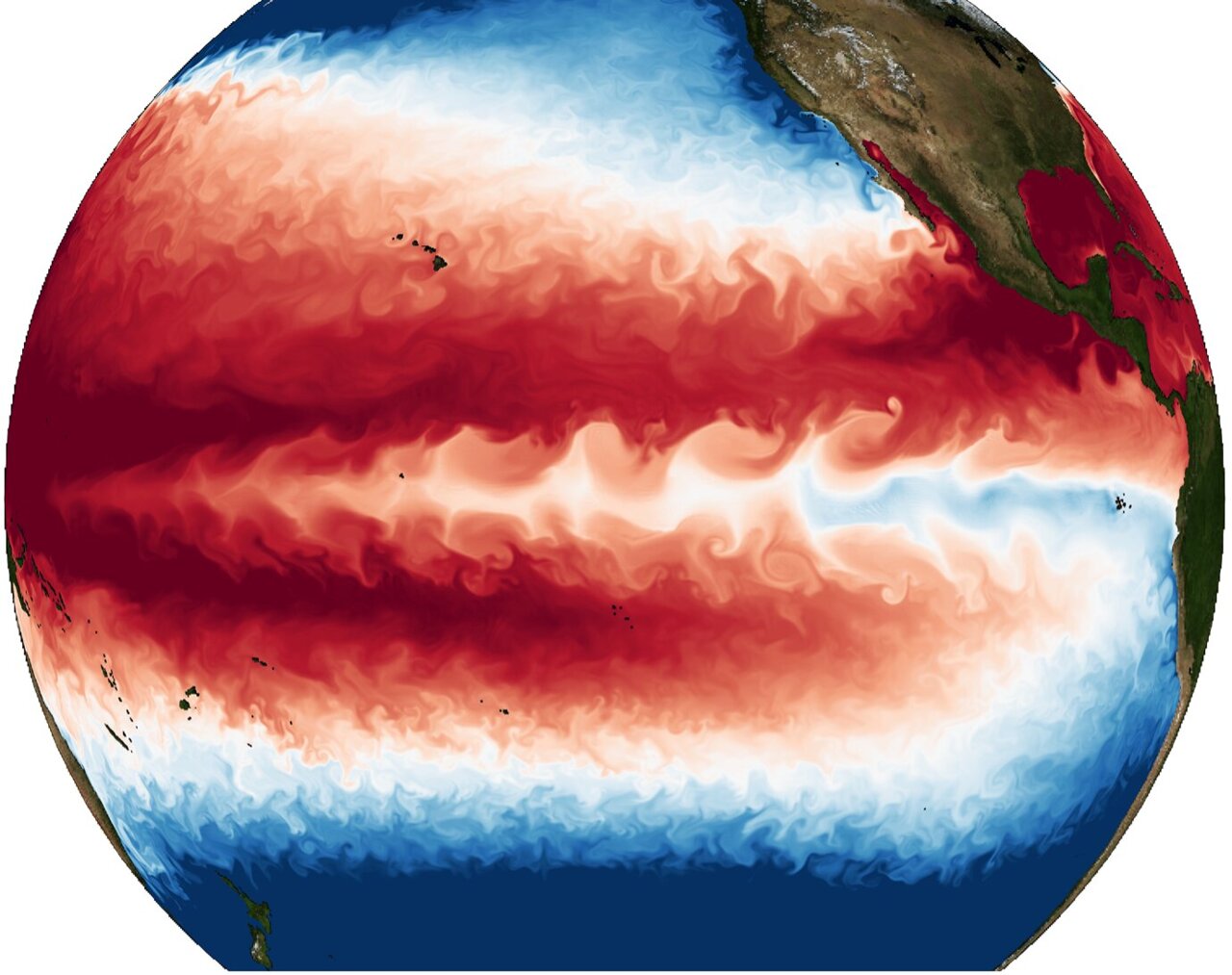
The cycling between warm El Niño and cold La Niña conditions in the eastern Pacific (commonly referred to as the El Niño-Southern Oscillation, ENSO) has persisted without major interruptions for at least the last 11,000 years. This may change in the future according to a new study published in the journal Nature Climate Change by a team of scientists from the IBS Center for Climate Physics (ICCP) at Pusan National University in South Korea, the Max Planck Institute of Meteorology, Hamburg, Germany, and the University of Hawaiʻi at Mānoa, U.S.

The team conducted a series of global climate model simulations with an unprecedented spatial resolution of 10 km in the ocean and 25 km in the atmosphere. Boosted by the power of one of South Korea's fastest supercomputers (Aleph), the new ultra-high-resolution climate model simulations can now realistically simulate tropical cyclones in the atmosphere and tropical instability waves in the equatorial Pacific Ocean, which both play fundamental roles in the generation and termination of El Niño and La Niña events. "Our supercomputer ran non-stop for over one year to complete a series of century-long simulations covering present-day climate and two different global warming levels. The model generated 2 quadrillion bytes of data; enough to fill up about 2,000 hard disks," says Dr. Sun-Seon Lee who conducted the experiments.

Analyzing this enormous dataset, the team focused on a long-standing problem: how will ENSO change in response to increasing greenhouse gas concentrations. "Two generations of climate scientists have looked at this issue using climate models of varying complexity. Some models simulated weaker; others predicted larger eastern Pacific temperature swings in a future warmer climate. The jury was still out," says Prof. Axel Timmermann, co-corresponding author and Director of the ICCP. He adds "What is common to these models is that their simulated temperatures in the equatorial Pacific, west of Galapagos, were always too cold compared to the observations. This prevented them from properly representing the delicate balance between positive and negative feedback processes that are important in the ENSO cycle."

By capturing small-scale climatic processes at the highest computationally possible resolution, the ICCP team was able to alleviate these ocean temperature biases, leading to substantial improvements in the representations of ENSO and its response to Global Warming. "The result from our computer simulations is clear: Increasing CO2 concentrations will weaken the intensity of the ENSO temperature cycle,"

By tracing the movement of heat in the coupled atmosphere/ocean system the scientists identified the main culprit of the collapse of the ENSO system: Future El Niño events will lose heat to the atmosphere more quickly due to the evaporation of water vapor, which has the tendency to cool the ocean. In addition, the reduced future temperature difference between the eastern and western tropical Pacific will also inhibit the development of temperature extremes during the ENSO cycle. However, these two factors are partly offset by a projected future weakening of tropical instability waves. Normally these oceanic waves, which can encompass up to 30% of the earth's entire circumference, develop during La Niña conditions. They replace colder equatorial waters with warmer off-equatorial water, thereby accelerating the demise of a La Niña event. The new computer simulations, which resolve the detailed structure of these waves, demonstrate that the associated negative feedback for ENSO will weaken in the future.

"There is a tug-of-war between positive and negative feedbacks in the ENSO system, which tips over to the negative side in a warmer climate. This means future El Niño and La Niña events cannot develop their full amplitude anymore,"

Even though the year-to-year fluctuations in eastern equatorial Pacific temperatures are likely to weaken with human-induced warming according to this new study, the corresponding changes in El Niño and La Niña-related rainfall extremes will continue to increase due to an intensified hydrological cycle in a warmer climate
, as shown in recent studies by scientists from the ICCP and their international collaborators.

"Our research documents that unabated warming is likely to silence the world's most powerful natural climate swing which has been operating for thousands of years. We don't yet know the ecological consequences of this potential no-analog situation,"

Future high-resolution El Niño/Southern Oscillation dynamics, Nature Climate Change (2021)
https://www.nature.com/articles/s41558-021-01132-4
“There are three classes of people: those who see. Those who see when they are shown. Those who do not see.” ― anonymous

Insensible before the wave so soon released by callous fate. Affected most, they understand the least, and understanding, when it comes, invariably arrives too late

gerontocrat

  • Multi-year ice
  • Posts: 20612
    • View Profile
  • Liked: 5308
  • Likes Given: 69
Re: 2021 ENSO
« Reply #25 on: September 09, 2021, 04:31:45 PM »
EL NIÑO/SOUTHERN OSCILLATION (ENSO)
DIAGNOSTIC DISCUSSION
issued by
CLIMATE PREDICTION CENTER/NCEP/NWS

and the International Research Institute for Climate and Society
9 September 2021
 
ENSO Alert System Status: La Niña Watch

 
Synopsis:  A transition from ENSO-neutral to La Niña is favored in the next couple of months, with a 70-80% chance of La Niña during the Northern Hemisphere winter 2021-22.

In the last month, ENSO-neutral continued with near-to-below average sea surface temperatures (SSTs) persisting in the central and eastern equatorial Pacific [Fig. 1]. In the last week, all of the Niño index values ranged from -0.2°C to -0.3°C [Fig. 2]. Negative subsurface temperature anomalies (averaged from 180-100°W) remained steady in August [Fig. 3], reflecting below-average temperatures that extended from the surface to ~250m depth in the eastern Pacific Ocean [Fig. 4]. Low-level wind anomalies were easterly over the western Pacific Ocean, while upper-level wind anomalies were westerly over the western and east-central Pacific. Tropical convection was suppressed near and west of the Date Line and enhanced over Indonesia [Fig. 5]. Given these conditions, the ocean-atmosphere system reflected ENSO-neutral, but is edging toward La Niña.

The IRI/CPC plume average of forecasts for the Niño-3.4 SST region from the last month favored borderline or weak La Niña during the fall and winter 2021-22 [Fig. 6]. The forecaster consensus this month, however, favors the latest predictions from the NCEP CFSv2 and the North American Multi-Model Ensemble, which suggest higher chances for the emergence of La Niña. At this time, forecasters anticipate La Niña to be of weak strength (seasonal average Niño-3.4 index values between -0.5°C to -0.9°C). In summary, a transition from ENSO-neutral to La Niña is favored in the next couple of months, with a 70-80% chance of La Niña during the Northern Hemisphere winter 2021-22 (click CPC/IRI consensus forecast for the chances in each 3-month period).

This discussion is a consolidated effort of the National Oceanic and Atmospheric Administration (NOAA), NOAA's National Weather Service, and their funded institutions. Oceanic and atmospheric conditions are updated weekly on the Climate Prediction Center web site (El Niño/La Niña Current Conditions and Expert Discussions). Additional perspectives and analysis are also available in an ENSO blog. A probabilistic strength forecast is available here. The next ENSO Diagnostics Discussion is scheduled for 14 October 2021.

To receive an e-mail notification when the monthly ENSO Diagnostic Discussions are released, please send an e-mail message to: ncep.list.enso-update@noaa.gov.

 
Climate Prediction Center
5830 University Research Court
College Park, Maryland 20740
"Para a Causa do Povo a Luta Continua!"
"And that's all I'm going to say about that". Forrest Gump
"Damn, I wanted to see what happened next" (Epitaph)

John Batteen

  • Frazil ice
  • Posts: 225
    • View Profile
  • Liked: 60
  • Likes Given: 3
Re: 2021 ENSO
« Reply #26 on: September 09, 2021, 06:48:37 PM »
Oh, great.  Double dip la nina winter, here we come.

Rodius

  • Nilas ice
  • Posts: 2179
    • View Profile
  • Liked: 651
  • Likes Given: 46
Re: 2021 ENSO
« Reply #27 on: September 15, 2021, 08:55:40 AM »
Oh, great.  Double dip la nina winter, here we come.

This is great, another cooler and wetter summer for Australia.

BeeKnees

  • Nilas ice
  • Posts: 2319
    • View Profile
  • Liked: 338
  • Likes Given: 335
Re: 2021 ENSO
« Reply #28 on: September 15, 2021, 11:33:50 AM »
If you look back most la Nina are double dip.
The Russian State has embarked on a genocide of Ukrainians that is supported by the owner of this forum

Jacobus

  • New ice
  • Posts: 28
  • Concerned Citizen
    • View Profile
  • Liked: 24
  • Likes Given: 324
Re: 2021 ENSO
« Reply #29 on: September 15, 2021, 07:37:50 PM »
That likely means the drought situation in California will not improve.

Jim Hunt

  • First-year ice
  • Posts: 6270
  • Don't Vote NatC or PopCon, Save Lives!
    • View Profile
    • The Arctic sea ice Great White Con
  • Liked: 894
  • Likes Given: 87
Re: 2021 ENSO
« Reply #30 on: September 15, 2021, 10:25:46 PM »
A transition from ENSO-neutral to La Niña is favored in the next couple of months

The BoM concur:

http://www.bom.gov.au/climate/enso/outlook/

Quote
La Niña WATCH activated

The ENSO Outlook has been raised to La Niña WATCH. This means that while the El Niño-Southern Oscillation is currently neutral, the chance of a La Niña forming during the southern hemisphere spring has increased to around 50% - twice the normal likelihood.

This status change follows cooling in the tropical Pacific Ocean and an increase in the number of climate models suggesting La Niña thresholds may be reached in the coming months.
"The most revolutionary thing one can do always is to proclaim loudly what is happening" - Rosa Luxemburg

John Batteen

  • Frazil ice
  • Posts: 225
    • View Profile
  • Liked: 60
  • Likes Given: 3
Re: 2021 ENSO
« Reply #31 on: September 25, 2021, 12:57:02 AM »
That likely means the drought situation in California will not improve.

And much of the interior west and northern tier.  I was really hoping for a snowy winter this year.  We desperately need the moisture.

gerontocrat

  • Multi-year ice
  • Posts: 20612
    • View Profile
  • Liked: 5308
  • Likes Given: 69
Re: 2021 ENSO
« Reply #32 on: October 14, 2021, 05:20:12 PM »
That likely means the drought situation in California will not improve.

And much of the interior west and northern tier.  I was really hoping for a snowy winter this year.  We desperately need the moisture.
Moderate La Nina even more likely...

https://www.cpc.ncep.noaa.gov/products/analysis_monitoring/enso_advisory/ensodisc.shtml
Quote
EL NIÑO/SOUTHERN OSCILLATION (ENSO)
DIAGNOSTIC DISCUSSION
issued by
CLIMATE PREDICTION CENTER/NCEP/NWS
and the International Research Institute for Climate and Society
14 October 2021
 
ENSO Alert System Status: La Niña Advisory

 
Synopsis:  La Niña conditions have developed and are expected to continue with an 87% chance of La Niña in December 2021- February 2022.


In the past month, La Niña conditions emerged, as indicated by below-average sea surface temperatures (SSTs) across the central and east-central equatorial Pacific [Fig. 1]. In the last week, the Niño-3.4 and Niño-4 index values were -0.6°C and -0.7°C, respectively [Fig. 2]. The Niño-3 and Niño-1+2 indices were not as cool, with values at -0.3°C and 0.1°C. Below-average subsurface temperatures (averaged from 180-100°W) strengthened significantly in the past month [Fig. 3], as negative anomalies were observed at depth across most of the central and eastern Pacific Ocean [Fig. 4]. Low-level easterly wind anomalies and upper-level westerly wind anomalies were observed over most of the equatorial Pacific. Tropical convection was suppressed near and west of the Date Line and enhanced over Indonesia [Fig. 5], while the Southern Oscillation Index and Equatorial Southern Oscillation Index were both positive. Overall, the coupled ocean-atmosphere system was consistent with La Niña conditions.

The IRI/CPC plume average of forecasts for the Niño-3.4 SST index favors La Niña to continue through the fall and winter 2021-22 [Fig. 6]. The forecaster consensus also anticipates La Niña to continue through the winter, with ENSO-neutral predicted to return during March-May 2022. Because of the recent oceanic cooling and coupling to the atmosphere, forecasters now anticipate a 57% chance of one season (November-January) reaching -1.0°C or less in the Niño-3.4 index. Thus, at its peak, a moderate-strength La Niña is favored. In summary, La Niña conditions have developed and are expected to continue with an 87% chance of La Niña in December 2021- February 2022 (click CPC/IRI consensus forecast for the chances in each 3-month period).

La Niña is anticipated to affect temperature and precipitation across the United States during the upcoming months (the 3-month seasonal temperature and precipitation outlooks will be updated on Thurs. October 21st).

This discussion is a consolidated effort of the National Oceanic and Atmospheric Administration (NOAA), NOAA's National Weather Service, and their funded institutions. Oceanic and atmospheric conditions are updated weekly on the Climate Prediction Center web site (El Niño/La Niña Current Conditions and Expert Discussions). Additional perspectives and analysis are also available in an ENSO blog. A probabilistic strength forecast is available here. The next ENSO Diagnostics Discussion is scheduled for 11 November 2021.

To receive an e-mail notification when the monthly ENSO Diagnostic Discussions are released, please send an e-mail message to: ncep.list.enso-update@noaa.gov.

 
Climate Prediction Center
5830 University Research Court
College Park, Maryland 20740
[/size]
"Para a Causa do Povo a Luta Continua!"
"And that's all I'm going to say about that". Forrest Gump
"Damn, I wanted to see what happened next" (Epitaph)

gerontocrat

  • Multi-year ice
  • Posts: 20612
    • View Profile
  • Liked: 5308
  • Likes Given: 69
Re: 2021 ENSO
« Reply #33 on: November 11, 2021, 06:08:03 PM »
It's La Nina this Winter & maybe Spring

Quote
EL NIÑO/SOUTHERN OSCILLATION (ENSO)
DIAGNOSTIC DISCUSSION
issued by
CLIMATE PREDICTION CENTER/NCEP/NWS
and the International Research Institute for Climate and Society
11 November 2021
 
ENSO Alert System Status: La Niña Advisory


Synopsis:  La Niña is likely to continue through the Northern Hemisphere winter 2021-22 (~90% chance) and into spring 2022 (~50% chance during March-May).

La Niña strengthened in the last month, with below-average sea surface temperatures (SSTs) evident across most of the equatorial Pacific [Fig. 1]. In the last week, all of the Niño index values were between -0.7°C and -1.0°C, with the coolest anomalies in the Niño-3.4 region [Fig. 2]. Below-average subsurface temperatures (averaged from 180-100°W) were roughly the same amplitude at this time last month [Fig. 3], and reflected the prevalence of below-average temperatures in the eastern Pacific Ocean [Fig. 4]. Low-level easterly and upper-level westerly wind anomalies were again observed over parts of the equatorial Pacific, although weaker than last month. Tropical convection was suppressed near and west of the Date Line and was slightly enhanced over Indonesia [Fig. 5]. The Southern Oscillation Index and Equatorial Southern Oscillation Index remained positive. Overall, the coupled ocean-atmosphere system was consistent with La Niña.

The IRI/CPC plume average of forecasts for the Niño-3.4 SST index favors La Niña to continue through January-March 2022 season [Fig. 6]. The forecaster consensus anticipates La Niña to persist longer, potentially returning to ENSO-neutral during April-June 2022. The Niño-3.4 index has a 66% chance of reaching a value less than -1.0°C during November 2021 - January 2022, but only a 14% chance of being below -1.5°C. Thus, at its peak, a moderate-strength La Niña is favored. In summary, La Niña is likely to continue through the Northern Hemisphere winter 2021-22 (~90% chance) and into spring 2022 (~50% chance during March-May; click CPC/IRI consensus forecast for the chances in each 3-month period).

La Niña is anticipated to affect temperature and precipitation across the United States during the upcoming months (the 3-month seasonal temperature and precipitation outlooks will be updated on Thurs. Nov. 18th).

This discussion is a consolidated effort of the National Oceanic and Atmospheric Administration (NOAA), NOAA's National Weather Service, and their funded institutions. Oceanic and atmospheric conditions are updated weekly on the Climate Prediction Center web site (El Niño/La Niña Current Conditions and Expert Discussions). Additional perspectives and analysis are also available in an ENSO blog. A probabilistic strength forecast is available here. The next ENSO Diagnostics Discussion is scheduled for 9 December 2021.

To receive an e-mail notification when the monthly ENSO Diagnostic Discussions are released, please send an e-mail message to: ncep.list.enso-update@noaa.gov.

 
Climate Prediction Center
5830 University Research Court
College Park, Maryland 20740
[/size]
"Para a Causa do Povo a Luta Continua!"
"And that's all I'm going to say about that". Forrest Gump
"Damn, I wanted to see what happened next" (Epitaph)

kassy

  • Moderator
  • First-year ice
  • Posts: 8333
    • View Profile
  • Liked: 2053
  • Likes Given: 1989
Re: 2021 ENSO
« Reply #34 on: November 23, 2021, 06:51:11 PM »
Australia declares La Niña phenomenon has begun

Australia has said a La Niña event has developed for a second consecutive year, meaning there is a greater risk locally of floods and cyclones.

Last time the weather phenomenon contributed to "once in a century" rains battering parts of Australia.

But La Niña can lead to significant weather changes in different parts of the world.

The World Meteorological Organization (WMO) is yet to declare a La Niña but has warned one may re-emerge.

This year's event could be weaker, according to Australia's Bureau of Meteorology (Bom).

"Climate models suggest this La Niña will be short-lived, persisting until the late southern hemisphere summer or early autumn 2022," it said on Tuesday.

La Niña is described as one of the three phases of the weather occurrence known as the El Niño-Southern Oscillation (ENSO). This includes the warm phase called El Niño, the cooler La Niña and a neutral phase.

A La Niña develops when strong winds blow the warm surface waters of the Pacific away from South America and towards Indonesia. In their place, colder waters come up to the surface.

...

In Australia, La Niña increases the chance of cooler daytime temperatures - reducing the risk of heatwaves and bushfires.

But it tends to create wetter than normal conditions and can increase the frequency of tropical cyclones.

Queensland has been warned of heavy rainfall and possible flash flooding this week. Last week, floods prompted evacuation warnings in Forbes, New South Wales.

and more:
https://www.bbc.com/news/world-australia-59383008

PS: it will be interesting to see what type of of scale flood events this will lead too.
« Last Edit: November 23, 2021, 06:56:27 PM by kassy »
Þetta minnismerki er til vitnis um að við vitum hvað er að gerast og hvað þarf að gera. Aðeins þú veist hvort við gerðum eitthvað.

Human Habitat Index

  • Frazil ice
  • Posts: 466
    • View Profile
  • Liked: 51
  • Likes Given: 368
Re: 2021 ENSO
« Reply #35 on: December 21, 2021, 02:36:41 PM »
I just watch the sea temp anomaly in the eastern Pacific.
Next El Nino could be strong.
There is a principle which is a bar against all information, which cannot fail to keep a man in everlasting ignorance. That principle is contempt prior to investigation. - Herbert Spencer